
PUBLISHER: TeleGeography | PRODUCT CODE: 1384284

PUBLISHER: TeleGeography | PRODUCT CODE: 1384284
'Geocoded Dataset License' options: Submarine Cable Map, Cloud Infrastructure Map, Internet Exchange Map, or Data Center Research Map
Please contact us using the inquiry form for pricing information.
TeleGeography's geocoded map data-now in your back pocket.
You can't find these insights anywhere else.
SAMPLE VIEW
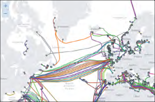
The “Submarine Cable Map” is famous for a reason. With updates almost every day, no other resource comes close to matching our accuracy of the world's major submarine cable systems and landing stations.
Our globe-trotting team of analysts keeps their fingers on the pulse of the industry to ensure that the most recent submarine cable deployments, new landing points, changes in topology, and cable retirements are reflected.
By licensing this dataset, you'll have uninterrupted access to our very latest insights, refreshed automatically on a rolling basis.
What's Included:
Subscribers have access to the following data points for each submarine cable shown on the map:
- Official submarine cable system name
- Country
- Planning status
- Ready for service date (RFS)
- Cable system length in kilometers
- Owners of the system
- Suppliers that laid down the submarine cable
- Official URL of the system
- Landing points
Other Geocoded Datasets
Looking for cloud, internet exchange, or data center insights?
We've got those, too. Geocoded datasets from the following TeleGeography maps are also available for licensing.
Cloud Infrastructure Map
Includes all cloud regions and on-ramp locations for content service providers, cloud exchanges and on-ramp locations for data center operators, and WAN services for network service providers, all at the metro area level.
- Cloud Service Provider Cloud Regions
- Cloud Service Provider Local Zones
- Cloud Service Provider On-Ramps
- Data Center Operator Cloud Exchanges
- Data Center Operator On-Ramps
- Network Service Provider WAN-Services (DIA/IP Access, DWDM, EoMPLS, EoSDH/EoSONET, MPLS/IP-VPN, SONET/SDH, T/E Carrier, VPN/VPLS)
- Network Service Provider Cloud Dedicated Connections
Internet Exchange Map
Internet exchanges at the building level.
- Internet Exchanges
- Buildings
Data Center Research Map
Data center sites at the building level.
- Operators
- Bandwidth Providers
- Buildings
How It Works
The delivery process is simple, no matter which dataset(s) you choose. First, we send you our map data as a JSON API-including GeoJSON and JSON files-through Amazon Simple Storage Service (Amazon S3).
Then our team uploads the API as a zip file with a timestamped filename. You'll need to permit our Amazon account to upload files to the S3 bucket, but we can guide you through it.
And that's it! The API will be automatically uploaded to your S3 bucket every time we make an update to the map.
Data Possibilities
This offering is truly a game changer for your next project. A few ideas:
- 1. Find your next data center location based on available bandwidth suppliers, access to the cloud, and proximity to submarine cables.
- 2. Overlay your network on top of TeleGeography's data to identify routing options and optimize your network expansion plans.
- 3. Design and present your network backed by TeleGeography's data.


Please contact us using the inquiry form for pricing information.