
PUBLISHER: Aviation & Defense Market Reports (A&D) | PRODUCT CODE: 1500331

PUBLISHER: Aviation & Defense Market Reports (A&D) | PRODUCT CODE: 1500331
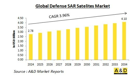
Global Defense SAR Satelites Market 2024-2034
USD 4.10 billion by 2034 at a Compound Annual Growth Rate (CAGR) of 3.96% over the forecast period 2024-2034.
.Introduction to the Global Defense SAR Satellite Market
SAR satellites are equipped with specialized radar technology that can generate high-resolution images of the Earth's surface, regardless of weather conditions or sunlight availability. Unlike traditional optical imagery satellites, SAR can penetrate cloud cover, fog, and even foliage, revealing hidden details crucial for defense purposes. This capability makes SAR satellites invaluable for a range of military applications where visibility might be compromised. The global defense SAR satellite market encompasses several key components. Satellite constellations consist of networks of SAR satellites working in tandem to provide comprehensive and continuous coverage of strategic areas. Ground segment infrastructure includes ground stations responsible for data acquisition, processing, and distribution to military users, ensuring that valuable intelligence is readily accessible. Additionally, SAR data services involve companies that offer analysis and interpretation of SAR imagery to extract critical information and provide actionable insights.
Technology Impact in the Defense SAR Satellite Market
Technological advancements are continuously transforming the capabilities of SAR satellites and propelling the growth of the defense SAR satellite market. One significant trend is the development of advanced radar technology. New radar systems with higher power outputs and improved signal processing techniques are enabling the creation of SAR satellites with superior resolution and penetration capabilities. These enhancements allow for more detailed and accurate imaging, crucial for defense applications. Another key trend is the miniaturization of satellites. Technological progress in this area allows for the launch of smaller and more affordable SAR satellites. This miniaturization facilitates the creation of larger constellations, providing wider coverage and more frequent revisit times over critical areas. These constellation networks, composed of multiple SAR satellites working in tandem, ensure persistent surveillance capabilities and continuous monitoring of strategic regions. The integration of artificial intelligence (AI) and machine learning (ML) is also revolutionizing the defense SAR satellite market. AI and ML algorithms enable faster and more accurate analysis of SAR imagery, allowing for real-time identification of potential threats and anomalies. This capability significantly enhances the responsiveness and effectiveness of defense operations. Additionally, the utilization of cloud computing for data storage and processing offers greater accessibility and scalability for defense users, facilitating rapid decision-making and improved operational efficiency. These advancements are leading to the development of a new generation of SAR satellites that are more powerful, versatile, and efficient. The integration of cutting-edge technologies is providing defense agencies with unparalleled intelligence gathering capabilities, enhancing their ability to monitor and respond to potential threats. The continuous evolution of SAR satellite technology underscores its critical role in modern defense strategies.
Key Drivers in the Global Defense SAR Satellite Market
Several factors are driving the growth of the global defense SAR satellite market. One major factor is heightened geopolitical tensions. Rising global tensions and regional conflicts are increasing the demand for advanced surveillance capabilities. SAR satellites offer a valuable tool for monitoring potential adversaries and detecting developing threats, providing crucial intelligence in volatile areas. The focus on border security is another significant driver. The need to secure vast coastlines and land borders is prompting military and security agencies to invest in SAR technology. This technology is effective for border patrol and the detection of illegal activities, offering enhanced capabilities for maintaining national security. Evolving threats also necessitate the use of advanced intelligence-gathering methods. The rise of asymmetric warfare tactics and the proliferation of unconventional threats require sophisticated surveillance. SAR satellites are uniquely capable of detecting hidden weapons caches, enemy movements, and other security concerns, making them indispensable for modern defense strategies. Enhanced maritime domain awareness is crucial for monitoring maritime activity related to piracy, illegal trafficking, and potential naval threats. SAR satellites provide unparalleled capabilities for tracking vessels at sea, regardless of weather conditions. This capability is essential for national security and ensures comprehensive surveillance of maritime domains. These drivers, combined with ongoing technological advancements, are making SAR satellites an increasingly vital asset for defense and intelligence agencies worldwide. As technology continues to evolve, the importance and utility of SAR satellites in defense operations will only grow, reinforcing their role in global security efforts. Regional Trends in the Global Defense SAR Satellite Market
Regional Trends in Global Defense SAR Satellite Market
North America and Europe are established military powers at the forefront of SAR satellite technology, continuously developing and deploying advanced constellations with sophisticated capabilities. These regions leverage their technological prowess and robust defense budgets to maintain a competitive edge in global surveillance and intelligence gathering. In the Asia-Pacific region, the rise of regional powers like China and India, coupled with growing territorial disputes, is driving significant demand for advanced SAR satellites. These nations are investing heavily in satellite technology to enhance their surveillance capabilities and assert their strategic interests in contested areas. Concerns about regional security and border control are fueling investment in SAR technology by countries in the Middle East. These nations prioritize acquiring advanced surveillance tools to monitor their borders and ensure national security amidst a volatile geopolitical landscape. In the rest of the world, developing nations are increasingly recognizing the value of SAR satellites. They are exploring options for acquiring these capabilities or partnering with established spacefaring nations to enhance their own intelligence-gathering efforts. This trend reflects a growing global acknowledgment of the strategic importance of advanced surveillance technologies.
Key Defense SAR Satellites Programs
Hanwha Systems Co. and Korea Aerospace Industries Ltd., prominent aerospace and defense firms in Korea, have secured agreements with a government agency to collaborate on the development of ultra-compact synthetic aperture radar (SAR) satellites. Hanwha Systems, a division of Hanwha Group specializing in defense and air mobility, announced on Thursday that its contract with the Agency for Defense Development (ADD), a state-owned defense research institute, amounts to 67.9 billion won ($51 million).
DARPA has granted contracts to four companies under the Distributed Radar Image Formation Technology (DRIFT) program, aimed at deploying synthetic aperture radar (SAR) satellites in coordinated formation. These contracts, awarded to Umbra, Terran Orbital's PredaSAR unit, Northrop Grumman, and Jacobs between late 2022 and early 2023, seek to demonstrate innovative methods for collecting SAR imagery and develop advanced algorithms to process data from multiple satellites. The program is integral to DARPA's Mosaic Warfare strategy, which emphasizes the deployment of numerous weapon and sensor platforms to overwhelm adversaries
Table of Contents
SAR Satellite Market Report Definition
SAR Satellite Market Segmentation
By Application
By Component
By Region
SAR Satellite Market Analysis for next 10 Years
The 10-year SAR satellite market analysis would give a detailed overview of SAR satellite market growth, changing dynamics, technology adoption overviews and the overall market attractiveness is covered in this chapter.
Market Technologies of SAR Satellite Market
This segment covers the top 10 technologies that is expected to impact this market and the possible implications these technologies would have on the overall market.
Global SAR Satellite Market Forecast
The 10-year SAR satellite market forecast of this market is covered in detailed across the segments which are mentioned above.
Regional SAR satellite Market Trends & Forecast
The regional SAR satellite market trends, drivers, restraints and Challenges of this market, the Political, Economic, Social and Technology aspects are covered in this segment. The market forecast and scenario analysis across regions are also covered in detailed in this segment. The last part of the regional analysis includes profiling of the key companies, supplier landscape and company benchmarking. The current market size is estimated based on the normal scenario.
North America
Drivers, Restraints and Challenges
PEST
Market Forecast & Scenario Analysis
Key Companies
Supplier Tier Landscape
Company Benchmarking
Europe
Middle East
APAC
South America
Country Analysis of SAR Satellite Market
This chapter deals with the key defense programs in this market, it also covers the latest news and patents which have been filed in this market. Country level 10 year market forecast and scenario analysis are also covered in this chapter.
US
Defense Programs
Latest News
Patents
Current levels of technology maturation in this market
Market Forecast & Scenario Analysis
Canada
Italy
France
Germany
Netherlands
Belgium
Spain
Sweden
Greece
Australia
South Africa
India
China
Russia
South Korea
Japan
Malaysia
Singapore
Brazil
Opportunity Matrix for SAR Satellite Market
The opportunity matrix helps the readers understand the high opportunity segments in this market.
Expert Opinions on SAR Satellite Market Report
Hear from our experts their opinion of the possible analysis for this market.
Conclusions
About Aviation and Defense Market Reports
List of Tables
- Table 1: 10 Year Market Outlook, 2024-2034
- Table 2: Drivers, Impact Analysis, North America
- Table 3: Restraints, Impact Analysis, North America
- Table 4: Challenges, Impact Analysis, North America
- Table 5: Drivers, Impact Analysis, Europe
- Table 6: Restraints, Impact Analysis, Europe
- Table 7: Challenges, Impact Analysis, Europe
- Table 8: Drivers, Impact Analysis, Middle East
- Table 9: Restraints, Impact Analysis, Middle East
- Table 10: Challenges, Impact Analysis, Middle East
- Table 11: Drivers, Impact Analysis, APAC
- Table 12: Restraints, Impact Analysis, APAC
- Table 13: Challenges, Impact Analysis, APAC
- Table 14: Drivers, Impact Analysis, South America
- Table 15: Restraints, Impact Analysis, South America
- Table 16: Challenges, Impact Analysis, South America
- Table 17: Scenario Analysis, Scenario 1, By Region, 2024-2034
- Table 18: Scenario Analysis, Scenario 1, By Application, 2024-2034
- Table 19: Scenario Analysis, Scenario 1, By Component, 2024-2034
- Table 20: Scenario Analysis, Scenario 2, By Region, 2024-2034
- Table 21: Scenario Analysis, Scenario 2, By Application, 2024-2034
- Table 22: Scenario Analysis, Scenario 2, By Component, 2024-2034
List of Figures
- Figure 1: Global Defense SAR Satellite Market Forecast, 2024-2034
- Figure 2: Global Defense SAR Satellite Market Forecast, By Region, 2024-2034
- Figure 3: Global Defense SAR Satellite Market Forecast, By Application, 2024-2034
- Figure 4: Global Defense SAR Satellite Market Forecast, By Component, 2024-2034
- Figure 5: North America, Defense SAR Satellite Market, Market Forecast, 2024-2034
- Figure 6: Europe, Defense SAR Satellite Market, Market Forecast, 2024-2034
- Figure 7: Middle East, Defense SAR Satellite Market, Market Forecast, 2024-2034
- Figure 8: APAC, Defense SAR Satellite Market, Market Forecast, 2024-2034
- Figure 9: South America, Defense SAR Satellite Market, Market Forecast, 2024-2034
- Figure 10: United States, Defense SAR Satellite Market, Technology Maturation, 2024-2034
- Figure 11: United States, Defense SAR Satellite Market, Market Forecast, 2024-2034
- Figure 12: Canada, Defense SAR Satellite Market, Technology Maturation, 2024-2034
- Figure 13: Canada, Defense SAR Satellite Market, Market Forecast, 2024-2034
- Figure 14: Italy, Defense SAR Satellite Market, Technology Maturation, 2024-2034
- Figure 15: Italy, Defense SAR Satellite Market, Market Forecast, 2024-2034
- Figure 16: France, Defense SAR Satellite Market, Technology Maturation, 2024-2034
- Figure 17: France, Defense SAR Satellite Market, Market Forecast, 2024-2034
- Figure 18: Germany, Defense SAR Satellite Market, Technology Maturation, 2024-2034
- Figure 19: Germany, Defense SAR Satellite Market, Market Forecast, 2024-2034
- Figure 20: Netherlands, Defense SAR Satellite Market, Technology Maturation, 2024-2034
- Figure 21: Netherlands, Defense SAR Satellite Market, Market Forecast, 2024-2034
- Figure 22: Belgium, Defense SAR Satellite Market, Technology Maturation, 2024-2034
- Figure 23: Belgium, Defense SAR Satellite Market, Market Forecast, 2024-2034
- Figure 24: Spain, Defense SAR Satellite Market, Technology Maturation, 2024-2034
- Figure 25: Spain, Defense SAR Satellite Market, Market Forecast, 2024-2034
- Figure 26: Sweden, Defense SAR Satellite Market, Technology Maturation, 2024-2034
- Figure 27: Sweden, Defense SAR Satellite Market, Market Forecast, 2024-2034
- Figure 28: Brazil, Defense SAR Satellite Market, Technology Maturation, 2024-2034
- Figure 29: Brazil, Defense SAR Satellite Market, Market Forecast, 2024-2034
- Figure 30: Australia, Defense SAR Satellite Market, Technology Maturation, 2024-2034
- Figure 31: Australia, Defense SAR Satellite Market, Market Forecast, 2024-2034
- Figure 32: India, Defense SAR Satellite Market, Technology Maturation, 2024-2034
- Figure 33: India, Defense SAR Satellite Market, Market Forecast, 2024-2034
- Figure 34: China, Defense SAR Satellite Market, Technology Maturation, 2024-2034
- Figure 35: China, Defense SAR Satellite Market, Market Forecast, 2024-2034
- Figure 36: Saudi Arabia, Defense SAR Satellite Market, Technology Maturation, 2024-2034
- Figure 37: Saudi Arabia, Defense SAR Satellite Market, Market Forecast, 2024-2034
- Figure 38: South Korea, Defense SAR Satellite Market, Technology Maturation, 2024-2034
- Figure 39: South Korea, Defense SAR Satellite Market, Market Forecast, 2024-2034
- Figure 40: Japan, Defense SAR Satellite Market, Technology Maturation, 2024-2034
- Figure 41: Japan, Defense SAR Satellite Market, Market Forecast, 2024-2034
- Figure 42: Malaysia, Defense SAR Satellite Market, Technology Maturation, 2024-2034
- Figure 43: Malaysia, Defense SAR Satellite Market, Market Forecast, 2024-2034
- Figure 44: Singapore, Defense SAR Satellite Market, Technology Maturation, 2024-2034
- Figure 45: Singapore, Defense SAR Satellite Market, Market Forecast, 2024-2034
- Figure 46: United Kingdom, Defense SAR Satellite Market, Technology Maturation, 2024-2034
- Figure 47: United Kingdom, Defense SAR Satellite Market, Market Forecast, 2024-2034
- Figure 48: Opportunity Analysis, Defense SAR Satellite Market, By Region (Cumulative Market), 2024-2034
- Figure 49: Opportunity Analysis, Defense SAR Satellite Market, By Region (CAGR), 2024-2034
- Figure 50: Opportunity Analysis, Defense SAR Satellite Market, By Application (Cumulative Market), 2024-2034
- Figure 51: Opportunity Analysis, Defense SAR Satellite Market, By Application (CAGR), 2024-2034
- Figure 52: Opportunity Analysis, Defense SAR Satellite Market, By Component (Cumulative Market), 2024-2034
- Figure 53: Opportunity Analysis, Defense SAR Satellite Market, By Component (CAGR), 2024-2034
- Figure 54: Scenario Analysis, Defense SAR Satellite Market, Cumulative Market, 2024-2034
- Figure 55: Scenario Analysis, Defense SAR Satellite Market, Global Market, 2024-2034
- Figure 56: Scenario 1, Defense SAR Satellite Market, Total Market, 2024-2034
- Figure 57: Scenario 1, Defense SAR Satellite Market, By Region, 2024-2034
- Figure 58: Scenario 1, Defense SAR Satellite Market, By Application, 2024-2034
- Figure 59: Scenario 1, Defense SAR Satellite Market, By Component, 2024-2034
- Figure 60: Scenario 2, Defense SAR Satellite Market, Total Market, 2024-2034
- Figure 61: Scenario 2, Defense SAR Satellite Market, By Region, 2024-2034
- Figure 62: Scenario 2, Defense SAR Satellite Market, By Application, 2024-2034
- Figure 63: Scenario 2, Defense SAR Satellite Market, By Component, 2024-2034
- Figure 64: Company Benchmark, Defense SAR Satellite Market, 2024-2034

