
PUBLISHER: Global Market Insights Inc. | PRODUCT CODE: 1773241

PUBLISHER: Global Market Insights Inc. | PRODUCT CODE: 1773241
Land Survey Equipment Market Opportunity, Growth Drivers, Industry Trend Analysis, and Forecast 2025 - 2034
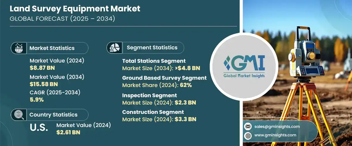
The Global Land Survey Equipment Market was valued at USD 8.87 billion in 2024 and is estimated to grow at a CAGR of 5.9% to reach USD 15.58 billion by 2034. This expansion is driven by the growing need for accurate geospatial information across sectors such as agriculture, construction, infrastructure, and mining. As industries continue to prioritize efficiency, safety, and precision, demand for next-generation surveying technologies has gained momentum. Traditional surveying techniques are rapidly being replaced by advanced tools like GNSS receivers, robotic total stations, and 3D laser scanners. These solutions enable surveyors to collect data faster and more accurately, resulting in improved terrain mapping and better project execution. Surveying technology has become indispensable in multiple applications, from optimizing land usage in agriculture to enhancing operational safety in mining.
Industries around the world are now increasingly aware of the advantages these modern instruments bring to complex land development and planning initiatives. These advanced surveying tools, such as GNSS receivers, robotic total stations, and 3D laser scanners, offer unmatched precision, faster data collection, and real-time analytics, helping reduce project timelines and eliminate costly errors. From infrastructure development and transportation planning to large-scale agricultural and mining operations, the ability to capture high-resolution spatial data in a fraction of the time has revolutionized how projects are initiated, managed, and executed. Sectors like construction, utilities, and energy are also turning to these innovations to streamline workflow, enhance accuracy in mapping and modeling, and comply with increasingly stringent regulations around safety and environmental impact.
| Market Scope | |
|---|---|
| Start Year | 2024 |
| Forecast Year | 2025-2034 |
| Start Value | $8.87 Billion |
| Forecast Value | $15.58 Billion |
| CAGR | 5.9% |
In 2024, the total stations segment held a 34.04% share and is anticipated to hit USD 4.8 billion by 2034. Their integrated ability to measure angles and distances makes them highly valuable for high-precision work. Their versatility and cost-effectiveness make them a preferred tool across a range of sectors, particularly for transportation and urban infrastructure developments. Recent innovations such as GNSS compatibility, wireless connectivity, and robotic automation are streamlining workflow and expanding their capabilities.
Ground-based survey systems segment held a 62% share in 2024 and is expected to grow at a CAGR of 5% from 2025 to 2034. This category covers both traditional and contemporary land survey equipment like GNSS systems, levels, and total stations. Their adaptability, reliability, and accessibility make them suitable for a broad array of project scopes, particularly in sectors like construction and city planning. Ground-based surveys remain essential across high-growth markets in Asia and Europe, where large-scale urban infrastructure continues to drive demand.
U.S. Land Survey Equipment Market accounted for a 77.1% share in 2024, generating USD 2.61 billion. North America leads globally in adopting advanced land surveying systems, including AI-integrated analytics, 3D scanning technologies, and UAV-based survey tools. The U.S. market stands out for its fast embrace of digitalization, especially through initiatives in smart infrastructure and construction digitization. Companies like Hexagon and Trimble play a major role in shaping the region's technological landscape by continually investing in product upgrades, research, and digital transformation to meet the growing need for real-time, high-accuracy data.
Key players shaping the Land Survey Equipment Industry include GeoTech, Hexagon, Topcon, Trimble, Stonex, DeepWell, FARO, Bosch Tools, Emlid Tech, and Shanghai Huace Navigation Technology. Companies in the land survey equipment market are investing significantly in R&D to create innovative, multi-functional, and high-accuracy solutions that cater to evolving industry demands. Many are integrating AI, IoT, and wireless technologies into survey equipment to enhance automation, real-time data processing, and cloud compatibility. Partnerships and strategic collaborations with construction and infrastructure firms are also key to expanding client bases. Players are emphasizing the development of compact, rugged, and mobile-friendly devices to address remote and urban survey challenges. Additionally, companies are localizing production and support services to better cater to regional markets while focusing on sustainability and long-term serviceability of equipment.
Table of Contents
Chapter 1 Methodology & Scope
- 1.1 Research design
- 1.1.1 Research approach
- 1.1.2 Data collection methods
- 1.2 Base estimates & calculations
- 1.2.1 Base year calculation
- 1.2.2 Key trends for market estimation
- 1.3 Forecast model
- 1.4 Primary research and validation
- 1.4.1 Primary sources
- 1.4.2 Data mining sources
- 1.5 Market scope & definition
Chapter 2 Executive Summary
- 2.1 Industry synopsis, 2021 – 2034
- 2.2 Key market trends
- 2.2.1 Regional
- 2.2.2 Product
- 2.2.3 Survey method
- 2.2.4 Application
- 2.2.5 End Use
- 2.3 TAM Analysis, 2025-2034
- 2.4 CXO perspectives: Strategic imperatives
- 2.4.1 Key decision points for industry executives
- 2.4.2 Critical success factors for market players
- 2.5 Future Outlook and Strategic Recommendations
Chapter 3 Industry Insights
- 3.1 Industry ecosystem analysis
- 3.1.1 Supplier landscape
- 3.1.1.1 Electronic component suppliers
- 3.1.1.2 Equipment manufacturers
- 3.1.1.3 Service providers
- 3.1.1.4 System integrators
- 3.1.1.5 End use
- 3.1.2 Cost structure
- 3.1.3 Profit margin
- 3.1.4 Value addition at each stage
- 3.1.5 Factors impacting the supply chain
- 3.1.6 Disruptors
- 3.1.1 Supplier landscape
- 3.2 Impact on forces
- 3.2.1 Growth drivers
- 3.2.1.1 The global infrastructure boom drives demand for accurate land surveys
- 3.2.1.2 GNSS, 3D scanners, and drones revolutionize land surveying
- 3.2.1.3 Farmers and miners leverage survey tech for precision operations
- 3.2.1.4 GIS expansion fuels need for survey-grade geospatial data
- 3.2.2 Industry pitfalls & challenges
- 3.2.2.1 High costs of GNSS & 3D scanners restrict small survey firms
- 3.2.2.2 Skill gap hinders the adoption of advanced surveying technology
- 3.2.3 Market Opportunities
- 3.2.3.1 Government land assessment mandates sustain surveying demand
- 3.2.3.2 Integration of AR/VR for remote training and real-time survey assistance
- 3.2.1 Growth drivers
- 3.3 Growth potential analysis
- 3.4 Porter's analysis
- 3.5 PESTEL analysis
- 3.6 Technology & innovation landscape
- 3.6.1 Current technologies
- 3.6.1.1 High-precision RTK & PPK GNSS/GPS Systems
- 3.6.1.2 Robotic & Motorized Total Stations
- 3.6.1.3 Terrestrial & Mobile LiDAR in 3D Laser Scanners
- 3.6.1.4 Photogrammetry & LiDAR Mapping Drones/UAVs
- 3.6.2 Emerging technologies
- 3.6.2.1 AI & machine learning for data processing
- 3.6.2.2 Autonomous surveying robots
- 3.6.2.3 Augmented reality (AR) for field visualization
- 3.6.2.4 Blockchain for secure geospatial data management
- 3.6.1 Current technologies
- 3.7 Patent analysis
- 3.8 Regulatory landscape
- 3.8.1 North America
- 3.8.2 Europe
- 3.8.3 Asia Pacific
- 3.8.4 Latin America
- 3.8.5 Middle East & Africa
- 3.9 Production statistics
- 3.9.1 Production hubs
- 3.9.2 Consumption hubs
- 3.9.3 Export and import
- 3.10 Cost breakdown analysis
- 3.11 Sustainability analysis
- 3.11.1 Sustainable practices
- 3.11.2 Waste reduction strategies
- 3.11.3 Energy efficiency in production
- 3.11.4 Eco-friendly initiatives
- 3.11.5 Carbon footprint considerations
Chapter 4 Competitive Landscape, 2024
- 4.1 Introduction
- 4.2 Company market share analysis
- 4.2.1 North America
- 4.2.2 Europe
- 4.2.3 Asia Pacific
- 4.2.4 Latin America
- 4.2.5 Middle East & Africa
- 4.3 Competitive positioning matrix
- 4.4 Strategic outlook matrix
- 4.5 Key developments
- 4.5.1 Mergers & acquisitions
- 4.5.2 Partnerships & collaborations
- 4.5.3 New Product Launches
- 4.5.4 Expansion Plans and funding
Chapter 5 Market Estimates & Forecast, By Product, 2021 - 2034 ($Bn, Units)
- 5.1 Key trends
- 5.2 Total stations
- 5.3 GPS/GNSS systems
- 5.4 Laser scanners
- 5.5 Levels
- 5.6 Unmanned Aerial Vehicles (UAV)/Drones
- 5.7 Others
Chapter 6 Market Estimates & Forecast, By Survey Method, 2021 - 2034 ($Bn, Units)
- 6.1 Key trends
- 6.2 Ground-based surveys
- 6.3 Laser surveys
Chapter 7 Market Estimates & Forecast, By Application, 2021 - 2034 ($Bn, Units)
- 7.1 Key trends
- 7.2 Inspection
- 7.2.1 Quality control inspections
- 7.2.2 Structural inspections
- 7.2.3 Infrastructure inspections
- 7.3 Monitoring
- 7.3.1 Environmental monitoring
- 7.3.2 Land use monitoring
- 7.3.3 Geodetic monitoring
- 7.4 Mapping
- 7.5 Engineering & design
- 7.6 Volumetric calculation
- 7.6.1 Earthwork calculations
- 7.6.2 Stockpile volume calculations
- 7.6.3 Cut and fill volume calculations
- 7.7 Layout points
- 7.7.1 Site layout for construction
- 7.7.2 Surveying for pipelines and utilities
- 7.7.3 Road and highway layout
- 7.8 Geographic Information Systems (GIS)
- 7.9 Land development planning
- 7.10 Agricultural surveying
- 7.11 Others
Chapter 8 Market Estimates & Forecast, By End use, 2021 - 2034 ($Bn, Units)
- 8.1 Key trends
- 8.2 Construction
- 8.3 Oil & gas
- 8.4 Mining
- 8.5 Utilities
- 8.6 Agriculture
- 8.7 Defense & security
- 8.8 Others
Chapter 9 Market Estimates & Forecast, By Region, 2021 - 2034 ($Bn, Units)
- 9.1 North America
- 9.1.1 U.S.
- 9.1.2 Canada
- 9.2 Europe
- 9.2.1 UK
- 9.2.2 Germany
- 9.2.3 France
- 9.2.4 Italy
- 9.2.5 Spain
- 9.2.6 Russia
- 9.2.7 Nordics
- 9.3 Asia Pacific
- 9.3.1 China
- 9.3.2 India
- 9.3.3 Japan
- 9.3.4 South Korea
- 9.3.5 Australia
- 9.3.6 Southeast Asia
- 9.4 Latin America
- 9.4.1 Brazil
- 9.4.2 Mexico
- 9.4.3 Argentina
- 9.4.4 Chile
- 9.5 MEA
- 9.5.1 South Africa
- 9.5.2 Saudi Arabia
- 9.5.3 UAE
Chapter 10 Company Profiles
- 10.1 Aptella
- 10.2 Baseline Equipment Company
- 10.3 Bosch Tools
- 10.4 DeepWell
- 10.5 Emlid Tech
- 10.6 FARO
- 10.7 GeoTech
- 10.8 Guangdong KOLIDA Instrument
- 10.9 Hexagon
- 10.10 Hi-Target
- 10.11 Juniper Systems
- 10.12 Seiler Instrument Company
- 10.13 Shanghai Huace Navigation Technology
- 10.14 South Surveying & Mapping Technology Company
- 10.15 Spectra Geospatial
- 10.16 Stonex
- 10.17 Suparule Systems
- 10.18 Teledyne
- 10.19 Topcon
- 10.20 Trimble

