PUBLISHER: Global Market Insights Inc. | PRODUCT CODE: 2109182

PUBLISHER: Global Market Insights Inc. | PRODUCT CODE: 2109182
Military Geospatial Intelligence Market Opportunity, Growth Drivers, Industry Trend Analysis, and Forecast 2026 - 2035
The Global Military Geospatial Intelligence Market was valued at USD 13.2 billion in 2025 and is estimated to grow at a CAGR of 9.7% to reach USD 33.1 billion by 2035.
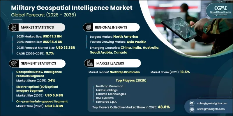
Market growth is fueled by increasing investments in satellite-based intelligence capabilities, broader integration of artificial intelligence into geospatial data analysis, continuous development of synthetic aperture radar (SAR) satellite networks, and the growing importance of multi-domain military operations. Rising emphasis on strengthening national security and achieving independent geospatial intelligence capabilities is also creating long-term opportunities across the defense sector. Defense organizations are expanding their investments in advanced surveillance technologies to improve situational awareness, mission planning, and operational decision-making. The growing need for accurate, real-time intelligence, combined with continuous advancements in remote sensing technologies and automated analytics, is accelerating market expansion. As military organizations modernize defense infrastructure and enhance digital battlefield capabilities, demand for advanced geospatial intelligence platforms, high-quality imagery, and data-driven defense solutions is expected to remain strong throughout the forecast period.
| Market Scope | |
|---|---|
| Start Year | 2025 |
| Forecast Year | 2026-2035 |
| Start Value | $13.2 Billion |
| Forecast Value | $33.1 Billion |
| CAGR | 9.7% |
Growing investments in satellite-enabled intelligence, surveillance, and reconnaissance capabilities are significantly contributing to the expansion of the military geospatial intelligence market. Governments worldwide are strengthening their space-based defense infrastructure to improve persistent Earth observation, real-time battlefield monitoring, and strategic intelligence collection. At the same time, artificial intelligence is becoming an essential component of modern geospatial intelligence by enabling rapid processing of large datasets, automating image interpretation, and improving the speed and accuracy of military decision-making. AI-powered analytics also enhance target recognition, intelligence generation, and operational planning by transforming vast amounts of geospatial information into actionable insights. These technological advancements are enabling defense organizations to improve mission readiness, strengthen surveillance capabilities, and optimize resource allocation across a wide range of military operations.
The geospatial data and intelligence products segment accounted for 34% share in 2025. The segment maintains its leading position due to the growing demand for high-resolution geospatial information, digital terrain models, mapping databases, and intelligence products that support mission planning, operational awareness, surveillance, target assessment, and strategic military decision-making. Continued investments in advanced Earth observation capabilities and increasing focus on strengthening domestic geospatial intelligence resources are expected to sustain long-term demand across defense and homeland security applications.
The electro-optical (EO)/optical imagery segment generated USD 5.6 billion in 2025. Strong demand for high-quality imagery used in reconnaissance, surveillance, battlefield assessment, and target identification continues to support segment growth. Electro-optical technologies provide detailed daytime imaging that enhances operational planning, border monitoring, and precision defense missions. Continuous improvements in imaging technologies, combined with wider deployment across airborne, satellite, and unmanned defense platforms, are further expanding the adoption of electro-optical solutions throughout modern military operations.
North America Military Geospatial Intelligence Market accounted for 44% share in 2025. The region continues to lead industry due to rising defense expenditures focused on space-based intelligence, surveillance, and reconnaissance capabilities, together with increasing deployment of artificial intelligence-driven geospatial intelligence platforms. Ongoing investments in advanced satellite technologies, secure intelligence infrastructure, real-time data processing capabilities, and next-generation defense systems are supporting regional market growth. The continued modernization of military operations and the increasing emphasis on secure geospatial intelligence solutions are expected to reinforce North America's leadership position during the forecast period.
Key players in the global military geospatial intelligence market include Leidos Holdings, Umbra (Umbra Lab Inc.), Esri, BAE Systems plc, Northrop Grumman Corporation, Palantir Technologies, Airbus Defence & Space, Capella Space, HawkEye 360, Saab AB, ICEYE, Leonardo S.p.A., L3Harris Technologies, Elbit Systems Ltd., BlackSky Technology, Thales Group, Vantor, Planet Labs PBC. Companies operating in the military geospatial intelligence market are strengthening their market position through continuous investments in advanced satellite technologies, artificial intelligence integration, and next-generation geospatial analytics platforms. Leading participants are expanding research and development activities to improve imaging capabilities, enhance real-time intelligence processing, and deliver highly accurate geospatial data for defense applications. Strategic collaborations with government agencies, defense organizations, and technology providers are helping companies broaden their solution portfolios and strengthen long-term contracts. Organizations are also focusing on cloud-enabled intelligence platforms, secure data management systems, and advanced analytics to improve operational efficiency. Geographic expansion, product innovation, technology upgrades, and long-term defense modernization partnerships remain key strategies adopted to increase competitiveness and reinforce their presence in the global military geospatial intelligence market.
Table of Contents
Chapter 1 Methodology and Scope
- 1.1 Market scope and definition
- 1.2 Research design
- 1.2.1 Research approach
- 1.2.2 Data collection methods
- 1.3 Data mining sources
- 1.3.1 Global
- 1.3.2 Regional/Country
- 1.4 Base estimates and calculations
- 1.4.1 Base year calculation
- 1.4.2 Key trends for market estimation
- 1.5 Primary research and validation
- 1.5.1 Primary sources
- 1.6 Forecast model
- 1.7 Research assumptions and limitations
Chapter 2 Executive Summary
- 2.1 Industry 360° synopsis, 2022 - 2035
- 2.2 Key market trends
- 2.2.1 Offering trends
- 2.2.2 Application trends
- 2.2.3 Technology trends
- 2.2.4 Deployment platform trends
- 2.2.5 End-user trends
- 2.2.6 Regional trends
- 2.3 TAM Analysis, 2026-2035
- 2.4 CXO perspectives: Strategic imperatives
Chapter 3 Industry Insights
- 3.1 Industry ecosystem analysis
- 3.1.1 Supplier Landscape
- 3.1.2 Profit Margin
- 3.1.3 Cost structure
- 3.1.4 Value addition at each stage
- 3.1.5 Factor affecting the value chain
- 3.1.6 Disruptions
- 3.2 Industry impact forces
- 3.2.1 Growth drivers
- 3.2.1.1 Increasing defense investments in satellite-based ISR capabilities
- 3.2.1.2 Rapid integration of Artificial Intelligence (AI) into geospatial intelligence analysis
- 3.2.1.3 Growing deployment of high-resolution Earth observation and SAR satellite constellations
- 3.2.1.4 Increasing adoption of multi-domain military operations
- 3.2.1.5 Expansion of sovereign geospatial intelligence capabilities and national security data autonomy
- 3.2.2 Industry pitfalls and challenges
- 3.2.2.1 High cost of satellite infrastructure and advanced GEOINT systems
- 3.2.2.2 Cybersecurity risks and data security concerns
- 3.2.3 Market opportunities
- 3.2.3.1 Expansion of AI-powered geospatial analytics and autonomous intelligence processing
- 3.2.3.2 Growing deployment of small satellite constellations and sovereign space capabilities
- 3.2.1 Growth drivers
- 3.3 Growth potential analysis
- 3.4 Regulatory landscape
- 3.4.1 North America
- 3.4.2 Europe
- 3.4.3 Asia Pacific
- 3.4.4 Latin America
- 3.4.5 Middle East & Africa
- 3.5 Porter's analysis
- 3.6 PESTEL analysis
- 3.7 Technology and Innovation landscape
- 3.7.1 Current technological trends
- 3.7.2 Emerging technologies
- 3.8 Price trends
- 3.8.1 By region
- 3.8.2 By product
- 3.9 Pricing Strategies
- 3.10 Emerging Business Models
- 3.11 Compliance Requirements
- 3.12 Patent and IP analysis
Chapter 4 Competitive Landscape, 2025
- 4.1 Introduction
- 4.2 Company market share analysis
- 4.2.1 By region
- 4.2.1.1 North America
- 4.2.1.2 Europe
- 4.2.1.3 Asia Pacific
- 4.2.1.4 Latin America
- 4.2.1.5 Middle East & Africa
- 4.2.2 Market concentration analysis
- 4.2.1 By region
- 4.3 Competitive benchmarking of key players
- 4.3.1 Financial performance comparison
- 4.3.1.1 Revenue
- 4.3.1.2 Profit margin
- 4.3.1.3 R&D
- 4.3.2 Product portfolio comparison
- 4.3.2.1 Product range breadth
- 4.3.2.2 Technology
- 4.3.2.3 Innovation
- 4.3.3 Geographic presence comparison
- 4.3.3.1 Global footprint analysis
- 4.3.3.2 Service network coverage
- 4.3.3.3 Market penetration by region
- 4.3.4 Competitive positioning matrix
- 4.3.4.1 Leaders
- 4.3.4.2 Challengers
- 4.3.4.3 Followers
- 4.3.4.4 Niche players
- 4.3.5 Strategic outlook matrix
- 4.3.1 Financial performance comparison
- 4.4 Key developments
- 4.4.1 Mergers and acquisitions
- 4.4.2 Partnerships and collaborations
- 4.4.3 Technological advancements
- 4.4.4 Expansion and investment strategies
- 4.4.5 Digital transformation initiatives
- 4.5 Emerging/ startup competitors landscape
Chapter 5 Market Estimates and Forecast, By Offering, 2022 - 2035 (USD Million)
- 5.1 Key trends
- 5.2 GEOINT collection systems & payloads
- 5.3 Geospatial data & intelligence products
- 5.4 Geospatial intelligence software
- 5.5 Geospatial intelligence services
Chapter 6 Market Estimates and Forecast, By Application, 2022 - 2035 (USD Million)
- 6.1 Key trends
- 6.2 Intelligence collection & surveillance
- 6.3 Targeting & precision strike support
- 6.4 Mission planning & terrain analysis
- 6.5 Battlespace awareness & command & control
- 6.6 Border, coastal & maritime security operations
- 6.7 GEOINT-enabled navigation & GPS-denied operations
- 6.8 Training, simulation & mission rehearsal
Chapter 7 Market Estimates and Forecast, By Technology, 2022 - 2035 (USD Million)
- 7.1 Key trends
- 7.2 Electro-optical (EO)/optical imagery
- 7.3 Synthetic aperture radar (SAR)
- 7.4 Hyperspectral & multispectral imaging
- 7.5 Full motion video (FMV) & wide-area motion imagery (WAMI)
- 7.6 LiDAR & 3D terrain mapping
Chapter 8 Market Estimates and Forecast, By Deployment Platform, 2022 - 2035 (USD Million)
- 8.1 Key trends
- 8.2 On-premise/air-gapped
- 8.3 Government cloud (GovCloud)
- 8.4 Hybrid
Chapter 9 Market Estimates and Forecast, By End-User, 2022 - 2035 (USD Million)
- 9.1 Key trends
- 9.2 Army / land forces
- 9.3 Navy / naval forces
- 9.4 Air force / aerospace forces
- 9.5 Joint & multi-domain commands
- 9.6 Intelligence agencies
- 9.7 Homeland security & border protection (incl. Coast Guards)
- 9.8 National mapping & geospatial agencies
Chapter 10 Market Estimates and Forecast, By Region, 2022 - 2035 (USD Million)
- 10.1 Key trends
- 10.2 North America
- 10.2.1 U.S.
- 10.2.2 Canada
- 10.3 Europe
- 10.3.1 Germany
- 10.3.2 UK
- 10.3.3 France
- 10.3.4 Russia
- 10.3.5 Italy
- 10.4 Asia Pacific
- 10.4.1 China
- 10.4.2 India
- 10.4.3 Japan
- 10.4.4 Australia
- 10.5 Latin America
- 10.5.1 Brazil
- 10.5.2 Mexico
- 10.5.3 Argentina
- 10.6 Middle East and Africa
- 10.6.1 Saudi Arabia
- 10.6.2 Egypt
Chapter 11 Company Profiles
- 11.1 Global Key Players
- 11.1.1 Northrop Grumman
- 11.1.2 Leidos Holdings
- 11.1.3 L3Harris Technologies
- 11.1.4 BAE Systems
- 11.1.5 Leonardo S.p.A.
- 11.2 Regional key players
- 11.2.1 North America
- 11.2.1.1 Vantor
- 11.2.1.2 Esri
- 11.2.1.3 Palantir Technologies
- 11.2.1.4 Planet Labs PBC
- 11.2.1.5 BlackSky Technology
- 11.2.1.6 Capella Space
- 11.2.1.7 HawkEye 360
- 11.2.2 Asia Pacific
- 11.2.2.1 Elbit Systems Ltd.
- 11.2.3 Europe
- 11.2.3.1 Airbus Defence & Space
- 11.2.3.2 Thales Group
- 11.2.3.3 Saab AB
- 11.2.3.4 ICEYE
- 11.2.1 North America
- 11.3 Niche Players/Disruptors
- 11.3.1 Umbra (Umbra Lab Inc.)

