
PUBLISHER: Mordor Intelligence | PRODUCT CODE: 1408216

PUBLISHER: Mordor Intelligence | PRODUCT CODE: 1408216
ANZ Geospatial Analytics - Market Share Analysis, Industry Trends & Statistics, Growth Forecasts 2024 - 2029
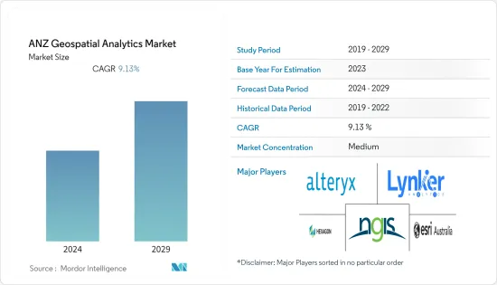
The ANZ geospatial analytics market size is expected to grow from USD 0.62 billion in the current year to USD 0.95 billion in the next five years at a CAGR of 9.13% during the forecast period. The ANZ geospatial analytics market is driven by the increasing demand from various public and private end-user industries, the presence of major market players, and the increasing demand for geospatial analytics in urban planning.
Key Highlights
- The ANZ geospatial analytics ecosystem has witnessed substantial growth in the past couple of years owing to the growth in innovative geospatial analytics solutions by the market players and the increasing use of advanced technologies such as artificial intelligence(AI) and machine learning(ML) for meaningful insights from the geospatial data. Moreover, the increasing use of location information to make informed decisions further drives the demand for geospatial capabilities and geospatial analytics solutions in the region.
- Market vendors in the region are using advanced technologies to offer innovative analytics capabilities in the geospatial domain, which is further analyzed to boost the demand for geospatial analytics solutions in the end-user industries across the region. For instance, Australia-based geospatial intelligence has considerable expertise in geospatial analysis, big data & link analytics, machine learning, artificial intelligence, and the development of effective user interfaces. These skills allow the company to develop sophisticated and innovative geospatial analytical tools that automate the extraction of data and information from large data sets and display this information in a format that supports informed decision-making.
- The increasing availability and accessibility of geospatial data from satellites, sensors, etc., aided the market's growth, as the geospatial data can provide substantial informed decisions and valuable insights by leveraging geospatial analytics solutions in organizations across the region. For instance, the National mapping agency Land Information New Zealand (LINZ) focused on publishing detailed geospatial data that models New Zealand's built and natural environments. LINZ shares its datasets-from road and river data to aerial imagery and LiDAR-on data.linz.govt.nz.
- Further, in May 2023, Vexcel Data Program announced free access to aerial imagery in New Zealand and Australia through its web-based platform, Viewer. This no-cost access provides commercial and government users with high-resolution, highly accurate imagery of major metro areas such as Perth, Auckland, Sydney, Melbourne, Brisbane, Wellington, and Christchurch. Australian and New Zealand organizations are eligible to participate in this free offering. Such factors are further expected to offer growth opportunities for the geospatial analytics market in the region over the forecast period. Such factors have driven organizations' demand for geospatial analytics solutions to maximize benefits and competitive edge from the spatial data from imagery, satellites, and sensors.
- During the COVID-19 pandemic, Geospatial Analytics Solutions witnessed substantial demand to offer Vital Information for Combating COVID-19 Pandemic in the region. Government organizations in the region, such as Emergency Management Spatial Information Network Australia (EMSINA), partnered with market vendors such as Esri Australia to combat the pandemic using geospatial datasets. Post-pandemic, the market is witnessing substantial growth owing to the increase in innovative and sophisticated geospatial analytics solutions developed by the major market vendors in the region.
ANZ Geospatial Analytics Market Trends
Agriculture Segment is Anticipated to Hold Significant Market Share
- The ANZ region's agriculture sector has grown substantially in the past few years, led by smart farming and precision agriculture practices. The region produces and exports a diverse range of agricultural products, including cattle, and wheat, making agriculture an important economic sector of the region. Various benefits are associated with geospatial analytics solutions, such as mapping field data, organizing and analyzing it, and monitoring their crops remotely.
- The agriculture sector in the region is witnessing substantial adoption of geospatial analytics solutions by integrating high-resolution imagery, field observations, and real-time data feeds to understand how to make the most of limited resources. Market vendors such as Esri Australia are actively innovating geospatial analytics solutions in the agriculture domain, thus impacting the growth of the market.
- Further, the region is promoting precision agriculture practices with the presence of many precision agriculture providers. Precision agriculture involves the use of various technologies, such as GPS, drones, sensors, and advanced analytics. Precision agriculture practices are expected to seek the use of geospatial analytics to improve farm decision-making and planning, thus positively driving the demand for geospatial analytics in the agriculture sector of the ANZ region.
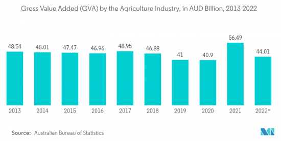
- Additionally, agriculture is becoming vital in the ANZ region, with the industry actively driving the region's GDP. The agriculture industry's adoption of geospatial analytics solutions in the region owing to the agriculture sector-specific geospatial solutions developed by market vendors are further analyzed to offer growth prospects to the agriculture industry, thus positively impacting the growth of the market. For instance, according to the Australian Bureau of Statistics data, as of September 2022, the gross value added (GVA) of the agriculture industry in Australia reached AUD 44.01 billion (~USD 28.92 billion).
Australia is Expected to Witness Substantial Growth
- Australia is expected to witness substantial adoption of geospatial analytics solutions in the coming years owing to the growing demand from various end-user industries ranging from agriculture to urban planning. Moreover, the country is home to some of the prominent market vendors who are continuously innovating their geospatial analytics offerings for a diverse range of industries, thus positively impacting the market growth in the country.
- For instance, Experian Australia offers geospatial analytics solutions for the retail sector in the country. The company provides benefits for retail organizations through its geospatial analytics solutions, such as more effective site selection, identification of profitability drivers, better alignment between retail/branch services, products, and consumers, more accurate estimates of store turnover, and improved understanding of competitor impact.
- Moreover, the high degree of urbanization in the country is further driving the demand for geospatial analytics solutions for proper and effective urban planning. For instance, according to the data from the World Bank, urbanization in Australia increased from 84.22% in 2005 to 86.49% in 2022. Further, the GIS, Digital Analytics, and Remote Sensing (GDARS) Area of Practice Committee in Australia recognizes the critical role that GIS, digital analytics, and remote sensing play in various applications, from urban planning and natural resource management to disaster response and public health.
- Further, utility companies in the country are partnering with geospatial analytics companies to deal with core data issues with network alignment and implement predictive maintenance strategies to reduce network failures and damages. For instance, in November 2022, Horizon Power's Geospatial Intelligence Program leveraged remote sensing, imagery, and advanced analytic technologies to deliver a geospatial intelligence solution that transforms the utility's ability to understand the state of the network quickly. With a network spanning thousands of kilometers, the geospatial intelligence program will optimize asset performance and keep the network reliable and safe. The utility company has selected geospatial specialist Altavec to deliver the program.
ANZ Geospatial Analytics Industry Overview
The ANZ geospatial analytics market is moderately consolidated owing to a few major market vendors holding significant market share. The market players in the region are indulging in partnership and acquisition activities and launching new innovative geospatial analytics solutions with the integration of advanced technologies. A few major market vendors in the ANZ geospatial analytics market include NGIS Australia Pty Ltd (NGIS), Alteryx, Hexagon AB, Esri Australia, and Lynker Analytics Ltd, among others.
In December 2022, Australia-based Geospatial Intelligence Pty Ltd, a specialist geospatial data, analysis, and analytics provider, announced a new partnership with Satellogic, one of the leading global providers of high-resolution satellite imagery. Satellogic designs, builds, and operates its fleet of earth observation (EO) satellites to collect affordable, high-resolution imagery. Its four multispectral bands (blue, red, green, near-IR) are delivered ortho-rectified and GIS-ready, available at 70 cm resolution on nadir.
Additional Benefits:
- The market estimate (ME) sheet in Excel format
- 3 months of analyst support
TABLE OF CONTENTS
1 INTRODUCTION
- 1.1 Study Assumptions and Market Definition
- 1.2 Scope of the Study
2 RESEARCH METHODOLOGY
3 EXECUTIVE SUMMARY
4 MARKET INSIGHTS
- 4.1 Market Overview
- 4.2 Industry Attractiveness - Porter's Five Forces Analysis
- 4.2.1 Bargaining Power of Buyers
- 4.2.2 Bargaining Power of Suppliers
- 4.2.3 Threat of New Entrants
- 4.2.4 Threat of Substitutes
- 4.2.5 Intensity of Competitive Rivalry
- 4.3 Industry Value Chain Analysis
- 4.4 Assessment of the Impact of COVID-19 on the Market
5 MARKET DYNAMICS
- 5.1 Market Drivers
- 5.1.1 Growing Demand for Geospatial Analytics in Smart City Development and Urban Planning
- 5.1.2 Integration of Advanced Technologies such as AI and ML in Geospatial Analytics Solutions
- 5.2 Market Restraints
- 5.2.1 Higher Costs Associated With Geospatial Analytics Solutions
6 MARKET SEGMENTATION
- 6.1 By Type
- 6.1.1 Surface Analysis
- 6.1.2 Network Analysis
- 6.1.3 Geovisualization
- 6.2 By End-user Vertical
- 6.2.1 Agriculture
- 6.2.2 Utility and Communication
- 6.2.3 Defense and Intelligence
- 6.2.4 Government
- 6.2.5 Mining and Natural Resources
- 6.2.6 Automotive and Transportation
- 6.2.7 Healthcare
- 6.2.8 Real Estate and Construction
- 6.2.9 Other End-user Verticals
- 6.3 By Country
- 6.3.1 Australia
- 6.3.2 New Zealand
7 COMPETITIVE LANDSCAPE
- 7.1 Company Profiles
- 7.1.1 NGIS Australia Pty Ltd (NGIS)
- 7.1.2 Alteryx
- 7.1.3 Hexagon AB
- 7.1.4 Esri Australia
- 7.1.5 Lynker Analytics Ltd
- 7.1.6 Intermap Technologies
- 7.1.7 Mapizy Pty Ltd.
- 7.1.8 New Zealand Geoanalytics Ltd.
- 7.1.9 CoreLogic NZ Limited
- 7.1.10 Abley Ltd
- 7.1.11 Geospatial Intelligence Pty Ltd.
8 INVESTMENT ANALYSIS
9 MARKET OPPORTUNITIES AND FUTURE TRENDS

