
PUBLISHER: Mordor Intelligence | PRODUCT CODE: 1940562

PUBLISHER: Mordor Intelligence | PRODUCT CODE: 1940562
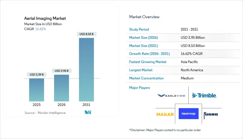
Aerial Imaging - Market Share Analysis, Industry Trends & Statistics, Growth Forecasts (2026 - 2031)
The aerial imaging market size in 2026 is estimated at USD 3.95 billion, growing from 2025 value of USD 3.39 billion with 2031 projections showing USD 8.53 billion, growing at 16.62% CAGR over 2026-2031.
Strong demand momentum arises from autonomous flight systems, AI-powered image analytics, and 5G-enabled location-based services. Precision farming alone has seen agricultural drones treat more than 500 million hectares, validating commercial-scale deployments. Enterprises increasingly favor centimeter-level accuracy for digital-twin initiatives, fueling rapid LiDAR adoption in infrastructure, mobility, and smart-city programs. Competitive intensity heightens as incumbents expand vertically through M&A while AI-native startups enter with cloud-first subscription models. Supply-side economics benefit from battery advances that lengthen mission endurance, while demand-side economics sharpen because UAV inspections cost 60% less than manned flights, accelerating payback periods for end users.
Global Aerial Imaging Market Trends and Insights
Proliferation of Location-Based Services Accelerates Platform Integration
Commercial drone flights grew 25% in 2024 as 5G coverage and IoT gateways enabled real-time, low-latency data streaming for enterprise users. Edge processors mounted on UAVs now fuse GPS, RTK, and visual-inertial odometry to deliver centimeter-level positioning, turning drones into mobile sensor hubs for infrastructure, mobility, and disaster-response applications. Integration with asset-management systems supports subscription monitoring models that offer predictable revenue for service providers. The combination of ultra-reliable communications and AI-on-device workflows shrinks data-to-decision cycles from hours to minutes, strengthening the aerial imaging market's value proposition for time-critical use cases. Growing datasets also feed autonomous-vehicle stacks, where high-resolution geodata increases model accuracy and safety compliance.
UAV Adoption Transforms Data-Collection Economics
End users report 60% inspection-cost reductions when replacing manned aircraft with UAVs, thanks to lower fuel spend, fewer personnel, and faster mobilization. Consumer-grade drones now carry RTK modules and multispectral payloads, democratizing access to professional imaging for small businesses. Battery endurance improvements extend mission times to 43 minutes, and autonomous flight plans remove pilot-license constraints, widening the adopter base. SaaS processing platforms convert uploads into actionable point clouds, orthomosaics, or vegetation indexes within hours, removing on-prem servers from total-cost calculations. The economics underpin recurring-revenue contracts that enhance vendor resilience across economic cycles.
Privacy Litigation Creates Operational Uncertainty
Insurance carriers' growing drone use for property underwriting has triggered legal pushback, with 61% of risk managers citing privacy-liability worries. A U.S. Fifth Circuit ruling upheld Texas statutes that bar image capture over private property without consent, narrowing commercial flight corridors. GDPR imposes explicit-consent requirements and multimillion-euro fines, raising the compliance bar for European operators. Public-sector deployment of counter-UAS systems further complicates airspace access, heightening operational risk premiums. These uncertainties may delay adoption among risk-averse enterprises, moderating aerial imaging market growth in the near term.
Other drivers and restraints analyzed in the detailed report include:
- Smart-City Digital-Twin Projects Drive Infrastructure Investment
- Agricultural Precision-Farming Scales Through Multispectral Innovation
- Regulatory Fragmentation Constrains Scalability
For complete list of drivers and restraints, kindly check the Table Of Contents.
Segment Analysis
UAVs retained 46.95% of 2025 revenue as their low operating costs and flexible form factors support inspection, mapping, and spraying missions. Hybrid-VTOL systems, though only a nascent slice of the aerial imaging market size, are forecast to grow 20.2% annually as defense and urban-air-mobility projects demand runway-less operations with fixed-wing efficiency. Major OEMs integrate electric propulsion and advanced flight-control laws, evidenced by Sikorsky's rotor-blown-wing prototype that completed more than 40 mode-switch landings . Cost-benefit analyses show hybrid platforms cutting per-mile surveillance expense by 30% relative to helicopters while offering longer endurance than rotary-only craft. L3Harris reports its Hybrid Quadrotor can carry modular LiDAR, EO/IR, and hyperspectral payloads, broadening mission portfolios . Investors have committed USD 430 million to Archer Aviation for defense-grade eVTOLs, underscoring cap-table confidence in this platform class . These dynamics suggest the aerial imaging market will diversify hardware fleets, blending rotorcraft agility with fixed-wing economics.
Vertical nadir workflows dominate for orthomosaic generation due to simplicity and high-throughput cameras. However, LiDAR's 21.3% CAGR reflects urgent enterprise need for centimeter-level digital twins that photogrammetry alone cannot deliver. Single-photon sensors now achieve 14 million measurements per second, decreasing flying hours over large corridors. LiDAR integration with AI algorithms expedites feature extraction, converting raw point clouds into classified assets in hours rather than days. Partnerships such as Inertial Labs and ideaForge streamline package weight and power draw for UAV deployment, expanding addressable acreage per flight. The aerial imaging market size for LiDAR payloads is therefore poised to outpace camera upgrades, as autonomous-vehicle developers and smart-city planners seek denser spatial datasets.
The Aerial Imaging Market Report is Segmented by Platform Type (Fixed-Wing Aircraft, Helicopters, and More), Imaging Technique (Vertical Imaging, Oblique Imaging, and More), Application (Geospatial Mapping, Infrastructure Planning, and More), End-User Industry (Government, Energy, and More), and Geography (North America, South America, Middle East and Africa, and More). The Market Forecasts are Provided in Terms of Value (USD).
Geography Analysis
North America delivered 36.95% of 2025 revenue on the strength of defense outlays, an entrenched aerospace industrial base, and regulatory test corridors that catalyze BVLOS experimentation. The United States awarded Maxar a USD 3.24 billion EOCL contract, anchoring multi-year imagery demand and funding R&D spillovers. Canada's 2025 RPAS rules formalized BVLOS approvals, easing cross-province pipeline-inspection workflows and broadening utility-sector uptake. Mexico's precision-ag-subsidy packages accelerate multispectral drone purchases, underscoring the region's cross-border technology diffusion.
Asia-Pacific is forecast to clock a 16.4% CAGR through 2031, led by China, which builds 70% of global commercial drones and channels policy support toward dual-use platforms valued at over 600 billion yuan by 2029. India's Production-Linked Incentive scheme subsidizes domestic UAV manufacturing, while public-sector crop-insurance pilots heighten demand for multispectral imaging. Japan and South Korea align 5G deployment with urban-air-mobility corridors, setting the stage for seamless real-time imagery feeds into city-operations centers. Australia's mining giants automate stockpile volume assessments via LiDAR, boosting APAC's share of high-value enterprise deployments.
Europe maintains stringent safety and privacy oversight yet fosters market certainty through harmonized EASA standards, tallying 1.6 million registered drone operators by 2024. Germany's sensor-engineering clusters advance lightweight LiDAR, while France leverages aerospace expertise for multi-modal imaging payloads. The UK's post-Brexit Civil Aviation Authority accelerates commercial-flight exemptions, supporting energy-sector corridor surveys. Southern Europe's Common Agricultural Policy funds reimburse farmers for precision-spray operations, expanding rural uptake. Complementary growth emerges across the Middle East and Africa, where infrastructure corridors and natural-resource monitoring generate greenfield demand for the aerial imaging market.
- EagleView Technologies Inc.
- Nearmap Ltd
- Fugro N.V.
- Trimble Inc.
- Maxar Technologies Inc.
- DJI Technology Co., Ltd.
- Hexagon AB (Leica Geosystems)
- Airbus Defence and Space
- Terra Flight Aerial Imaging Inc.
- Kucera International Inc.
- Cooper Aerial Surveys Co.
- Digital Aerial Solutions LLC
- SkyIMD Inc.
- Airobotics GmbH (Ondas Holdings)
- Aerobotics (Pty) Ltd
- DroneDeploy Inc.
- Teledyne Technologies Inc.
- ESRI (Environmental Systems Research Institute)
- Landiscor Real-Estate Mapping
- GeoVantage Inc. (Aeroptic LLC)
Additional Benefits:
- The market estimate (ME) sheet in Excel format
- 3 months of analyst support
TABLE OF CONTENTS
1 INTRODUCTION
- 1.1 Study Assumptions and Market Definition
- 1.2 Scope of the Study
2 RESEARCH METHODOLOGY
3 EXECUTIVE SUMMARY
4 MARKET LANDSCAPE
- 4.1 Market Overview
- 4.2 Market Drivers
- 4.2.1 Proliferation of location-based services (5G, IoT)
- 4.2.2 Rapid adoption of UAVs/drones for low-cost data capture
- 4.2.3 Growth in smart-city and infrastructure?digital-twin projects
- 4.2.4 Agricultural demand for crop-health multispectral imaging
- 4.2.5 AI-augmented image analytics reducing processing time (under-reported)
- 4.2.6 Demand for high-resolution geodata to train autonomous-vehicle stacks (under-reported)
- 4.3 Market Restraints
- 4.3.1 Rising data-privacy and surveillance-use lawsuits
- 4.3.2 Fragmented global and local air-regulation regimes
- 4.3.3 Cyber-attacks on aerial imaging data-streams (under-reported)
- 4.3.4 Competition from low-orbit constellation satellites (under-reported)
- 4.4 Value Chain Analysis
- 4.5 Regulatory Landscape
- 4.6 Technological Outlook
- 4.7 Porter's Five Forces Analysis
- 4.7.1 Bargaining Power of Suppliers
- 4.7.2 Bargaining Power of Buyers
- 4.7.3 Threat of New Entrants
- 4.7.4 Threat of Substitutes
- 4.7.5 Intensity of Competitive Rivalry
- 4.8 Investment and Funding Trends
- 4.9 Impact on Macroeconomic Factors
5 MARKET SIZE AND GROWTH FORECASTS (VALUE)
- 5.1 By Platform Type
- 5.1.1 Fixed-wing Aircraft
- 5.1.2 Helicopters
- 5.1.3 UAVs / Drones
- 5.1.4 Hybrid-VTOL Platforms
- 5.1.5 Other Platform Types
- 5.2 By Imaging Technique
- 5.2.1 Vertical (Nadir) Imaging
- 5.2.2 Oblique Imaging
- 5.2.3 Multispectral / Hyperspectral Imaging
- 5.2.4 LiDAR-based Imaging
- 5.2.5 Thermal / IR Imaging
- 5.3 By Application
- 5.3.1 Geospatial Mapping and Land Survey
- 5.3.2 Infrastructure and Urban Planning
- 5.3.3 Asset Inventory and Inspection
- 5.3.4 Environmental and Forestry Monitoring
- 5.3.5 Disaster and Emergency Management
- 5.3.6 Security, Surveillance and Defense
- 5.3.7 Agriculture and Precision Farming
- 5.3.8 Insurance Underwriting and Claims
- 5.3.9 Media and Entertainment
- 5.4 By End-user Industry
- 5.4.1 Government and Public Agencies
- 5.4.2 Construction and Real-Estate
- 5.4.3 Energy, Power and Utilities
- 5.4.4 Oil and Gas
- 5.4.5 Agriculture and Forestry
- 5.4.6 Defense and Homeland Security
- 5.4.7 Insurance
- 5.4.8 Mining and Quarrying
- 5.4.9 Other Industries
- 5.5 By Geography
- 5.5.1 North America
- 5.5.1.1 United States
- 5.5.1.2 Canada
- 5.5.1.3 Mexico
- 5.5.2 Europe
- 5.5.2.1 United Kingdom
- 5.5.2.2 Germany
- 5.5.2.3 France
- 5.5.2.4 Italy
- 5.5.2.5 Rest of Europe
- 5.5.3 Asia-Pacific
- 5.5.3.1 China
- 5.5.3.2 Japan
- 5.5.3.3 India
- 5.5.3.4 South Korea
- 5.5.3.5 Rest of Asia-Pacific
- 5.5.4 Middle East and Africa
- 5.5.4.1 Middle East
- 5.5.4.1.1 Israel
- 5.5.4.1.2 Saudi Arabia
- 5.5.4.1.3 United Arab Emirates
- 5.5.4.1.4 Turkey
- 5.5.4.1.5 Rest of Middle East
- 5.5.4.2 Africa
- 5.5.4.2.1 South Africa
- 5.5.4.2.2 Egypt
- 5.5.4.2.3 Rest of Africa
- 5.5.4.1 Middle East
- 5.5.5 South America
- 5.5.5.1 Brazil
- 5.5.5.2 Argentina
- 5.5.5.3 Rest of South America
- 5.5.1 North America
6 COMPETITIVE LANDSCAPE
- 6.1 Market Concentration
- 6.2 Strategic Moves
- 6.3 Market Share Analysis
- 6.4 Company Profiles (includes Global level Overview, Market level overview, Core Segments, Financials as available, Strategic Information, Market Rank/Share for key companies, Products and Services, and Recent Developments)
- 6.4.1 EagleView Technologies Inc.
- 6.4.2 Nearmap Ltd
- 6.4.3 Fugro N.V.
- 6.4.4 Trimble Inc.
- 6.4.5 Maxar Technologies Inc.
- 6.4.6 DJI Technology Co., Ltd.
- 6.4.7 Hexagon AB (Leica Geosystems)
- 6.4.8 Airbus Defence and Space
- 6.4.9 Terra Flight Aerial Imaging Inc.
- 6.4.10 Kucera International Inc.
- 6.4.11 Cooper Aerial Surveys Co.
- 6.4.12 Digital Aerial Solutions LLC
- 6.4.13 SkyIMD Inc.
- 6.4.14 Airobotics GmbH (Ondas Holdings)
- 6.4.15 Aerobotics (Pty) Ltd
- 6.4.16 DroneDeploy Inc.
- 6.4.17 Teledyne Technologies Inc.
- 6.4.18 ESRI (Environmental Systems Research Institute)
- 6.4.19 Landiscor Real-Estate Mapping
- 6.4.20 GeoVantage Inc. (Aeroptic LLC)
7 MARKET OPPORTUNITIES AND FUTURE OUTLOOK
- 7.1 White-space and Unmet-Need Assessment

