
PUBLISHER: Mordor Intelligence | PRODUCT CODE: 2065744

PUBLISHER: Mordor Intelligence | PRODUCT CODE: 2065744
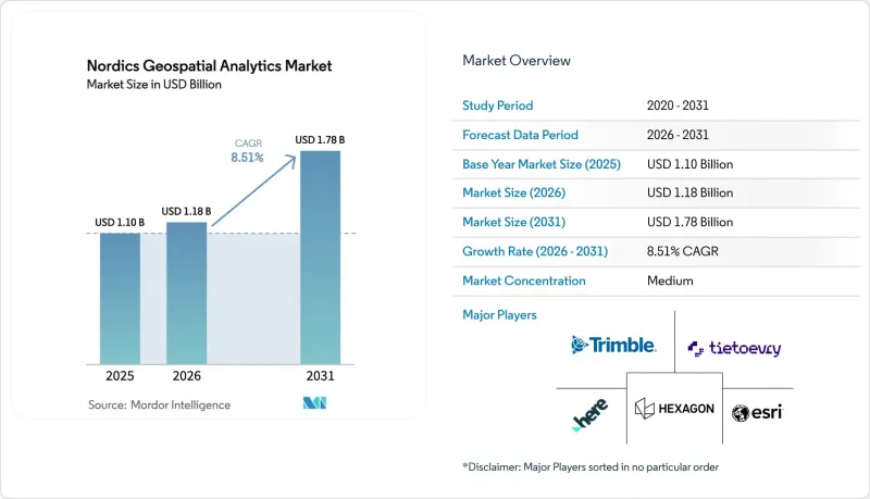
Nordics Geospatial Analytics - Market Share Analysis, Industry Trends & Statistics, Growth Forecasts (2026 - 2031)
According to Mordor Intelligence, the nordics geospatial analytics market size is projected to expand from USD 1.1 billion in 2025 and USD 1.18 billion in 2026 to USD 1.78 billion by 2031, registering a CAGR of 8.51% between 2026 to 2031.
This report is Segmented by Component (Solutions, Services), Analysis Type (Surface Analysis, Network Analysis, and More), Deployment Mode (On-Premise, Cloud, Edge, and Hybrid), Application (Urban Planning and Smart Cities, Transportation and Logistics Optimization, Environmental Monitoring and Climate Analysis, and More), and Geography. The Market Forecasts are Provided in Terms of Value (USD).
Nordics Geospatial Analytics Market Trends and Insights
Open Geodata And NSDI Maturity Lower Adoption Friction
Open-access policies continue to erode licensing barriers and expand the geospatial analytics market in the Nordics. Denmark's Kortforsyningen portal generated DKK 3.5 billion (USD 0.53 billion) in social value by 2016, proving that free foundational datasets unlock downstream commercial use. Norway's Spatial Data Act mandates open government geodata, enabling start-ups to prototype without up-front acquisition costs. Finland's Geological Survey openly provides bedrock and mineral layers, catalyzing exploration analytics. Sweden, by contrast, still recovers costs through Lantmateriet licensing, pushing vendors toward project-based bundles that hide data fees inside consulting engagements. Divergent regimes, therefore, shape the mix of software and services in each country.
EU Copernicus/EGNSS Uptake Expands Downstream Analytics
Copernicus delivers petabytes of multispectral and SAR scenes at no license cost, fuelling forestry carbon accounting, crop yield modeling, and Arctic sea-ice tracking across the Nordics. Galileo's free decimeter-level High Accuracy Service underpins precision agriculture and autonomous-vehicle pilots without the need for expensive RTK subscriptions. Trafikverket trained a self-supervised model on hundreds of terabytes of Copernicus and aerial imagery, slashing annotation effort for road-condition surveys. With EUSPA projecting global GNSS revenue to rise from EUR 199 billion in 2023 to EUR 492 billion by 2031, Nordic players enjoy a multiplier on service demand generated by publicly funded space infrastructure.
Mixed Data Access Regimes And Licensing Constraints
Sweden's cost-recovery model and GDPR rules raise barriers to fusing cadastral, demographic, and mobility data, dampening location-intelligence use cases versus fully open Denmark. Municipal utilities often impose bespoke sharing agreements on network geometries, forcing vendors into one-off negotiations that erode scalability. Cross-border corridors such as Rail Baltica expose further incompatibilities, slowing multinational deployments. Until harmonized standards mature, the Nordics geospatial analytics market must navigate a patchwork that adds time and legal cost to every expansion sprint.
Other drivers and restraints analyzed in the detailed report include:
- City-Scale Digital Twins And Smart Mobility Programs
- Energy Transition And Grid Digitization Initiatives
- Fragmented Municipal Procurement And Profiles
For complete list of drivers and restraints, kindly check the Table Of Contents.
Segment Analysis
Solutions held 64.60% of the Nordics geospatial analytics market share in 2025, underpinned by Hexagon AB, Environmental Systems Research Institute, and Trimble licensing. Yet Services is set to grow at an 11.30% CAGR, reflecting municipal need for data-integration, cloud-migration, and model-operations expertise.
In the medium term, the Nordics geospatial analytics market size for Services is projected to outpace Solutions as clients seek turnkey digital-twin life-cycle support. Consolidation is accelerating: Sitowise added LandPro and VVS-Kompetens to push Swedish headcount to 250 and annual sales to EUR 31 million (USD 35.0 million). Metria's SEK 650 million (USD 62.4 million) sale to Sikri Holding likewise signals private-equity appetite for annuity-style geospatial consultancies.
Geo-visualization contributed 33.40% of 2025 revenue, buoyed by immersive planning tools that win stakeholder buy-in. However, Spatial AI and Predictive Modelling are forecast to climb at 12.78% CAGR as machine-learning models transition from research to operations.
Spatial AI platforms for forestry, road maintenance, and offshore wind inspection reduce field costs by up to 60%, accelerating deployment across Scandinavia. The Nordics geospatial analytics market size attributed to Spatial AI is forecast to swell as Trafikverket's foundation model, Husqvarna's mower routing, and Terra Labs' biomass estimation gain traction. Older surface- and network-analysis workstreams remain vital but face price commoditization amid the diffusion of open source.
List of Companies Covered in this Report:
- Hexagon AB
- Environmental Systems Research Institute, Inc. (Esri)
- Geodata AS
- Esri Sverige AB
- Esri Finland Oy
- Geoinfo A/S
- Norkart AS
- Metria AB
- Spacemetric AB
- Gispo Oy
- Sitowise Group Oyj
- Solita Oy
- Tietoevry Oyj
- Norconsult Digital AS
- COWI A/S
- NIRAS A/S
- Sweco AB
- MapsPeople A/S
- HERE Global B.V.
- Trimble Inc.
- Bentley Systems, Incorporated
- Autodesk, Inc.
- Kongsberg Satellite Services AS
- ICEYE Oy
- Vaisala Oyj
- Geomatikk AS
- WSP Sverige AB
- CGI Suomi Oy
Additional Benefits:
- The market estimate (ME) sheet in Excel format
- 3 months of analyst support
TABLE OF CONTENTS
1 INTRODUCTION
- 1.1 Study Assumptions and Market Definition
- 1.2 Scope of the Study
2 RESEARCH METHODOLOGY
3 EXECUTIVE SUMMARY
4 MARKET LANDSCAPE
- 4.1 Market Overview
- 4.2 Market Drivers
- 4.2.1 Open Geodata and NSDI Maturity Lower Adoption Friction
- 4.2.2 EU Copernicus/EGNSS Uptake Expands Downstream Analytics
- 4.2.3 City-scale Digital Twins and Smart Mobility Programs
- 4.2.4 Energy Transition and Grid Digitization Initiatives
- 4.2.5 Offshore Wind Build-out and Marine Spatial Planning Needs
- 4.2.6 Arctic Connectivity Enabling Low-latency Data Flows
- 4.3 Market Restraints
- 4.3.1 Mixed Data Access Regimes and Licensing Constraints
- 4.3.2 Fragmented Municipal Procurement and Profiles
- 4.3.3 Arctic Backhaul/coverage Gaps for Real-time Workloads
- 4.3.4 Shortage of Production-grade GeoAI/Modelops Talent
- 4.4 Impact of Macroeconomic Factors
- 4.5 Industry Value Chain Analysis
- 4.6 Regulatory Landscape
- 4.7 Technological Outlook
- 4.8 Porter's Five Forces Analysis
- 4.8.1 Bargaining Power of Suppliers
- 4.8.2 Bargaining Power of Buyers
- 4.8.3 Threat of New Entrants
- 4.8.4 Threat of Substitutes
- 4.8.5 Intensity of Competitive Rivalry
- 4.9 Investment and Funding Trends
5 MARKET SIZE AND GROWTH FORECASTS (VALUE)
- 5.1 By Component
- 5.1.1 Solutions
- 5.1.2 Services
- 5.2 By Deployment Mode
- 5.2.1 On-Premise
- 5.2.2 Cloud
- 5.2.3 Edge and Hybrid
- 5.3 By Analysis Type
- 5.3.1 Surface Analysis
- 5.3.2 Network Analysis
- 5.3.3 Geo-visualization
- 5.3.4 Spatial AI and Predictive Modelling
- 5.3.5 Other Types
- 5.4 By Application
- 5.4.1 Urban Planning and Smart Cities
- 5.4.2 Transportation and Logistics Optimization
- 5.4.3 Environmental Monitoring and Climate Analysis
- 5.4.4 Disaster Management and Emergency Response
- 5.4.5 Agriculture and Precision Farming
- 5.4.6 Energy and Utilities Management
- 5.4.7 Defense, Intelligence, and Public Safety
- 5.4.8 Business Intelligence and Location Intelligence
- 5.4.9 Natural Resources and Mining
- 5.4.10 Other Applications
- 5.5 By Country
- 5.5.1 Sweden
- 5.5.2 Norway
- 5.5.3 Denmark
- 5.5.4 Finland
- 5.5.5 Iceland
6 COMPETITIVE LANDSCAPE
- 6.1 Market Concentration
- 6.2 Strategic Moves
- 6.3 Market Share Analysis
- 6.4 Company Profiles (includes Global Level Overview, Market Level Overview, Core Segments, Financials as available, Strategic Information, Market Rank/Share, Products and Services, Recent Developments)
- 6.4.1 Hexagon AB
- 6.4.2 Environmental Systems Research Institute, Inc. (Esri)
- 6.4.3 Geodata AS
- 6.4.4 Esri Sverige AB
- 6.4.5 Esri Finland Oy
- 6.4.6 Geoinfo A/S
- 6.4.7 Norkart AS
- 6.4.8 Metria AB
- 6.4.9 Spacemetric AB
- 6.4.10 Gispo Oy
- 6.4.11 Sitowise Group Oyj
- 6.4.12 Solita Oy
- 6.4.13 Tietoevry Oyj
- 6.4.14 Norconsult Digital AS
- 6.4.15 COWI A/S
- 6.4.16 NIRAS A/S
- 6.4.17 Sweco AB
- 6.4.18 MapsPeople A/S
- 6.4.19 HERE Global B.V.
- 6.4.20 Trimble Inc.
- 6.4.21 Bentley Systems, Incorporated
- 6.4.22 Autodesk, Inc.
- 6.4.23 Kongsberg Satellite Services AS
- 6.4.24 ICEYE Oy
- 6.4.25 Vaisala Oyj
- 6.4.26 Geomatikk AS
- 6.4.27 WSP Sverige AB
- 6.4.28 CGI Suomi Oy
7 MARKET OPPORTUNITIES AND FUTURE OUTLOOK
- 7.1 White-space and Unmet-Need Assessment

