PUBLISHER: Mordor Intelligence | PRODUCT CODE: 2113905

PUBLISHER: Mordor Intelligence | PRODUCT CODE: 2113905
Commercial Satellite Imaging - Market Share Analysis, Industry Trends & Statistics, Growth Forecasts (2026 - 2031)
According to Mordor Intelligence, the commercial satellite imaging market size reached USD 7.49 billion in 2026 and is projected to attain USD 13.62 billion by 2031, reflecting a 12.7% CAGR.
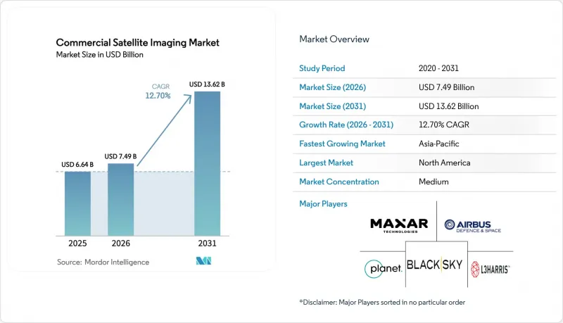
This report is Segmented by Application (Geospatial Data Acquisition and Mapping, Natural Resource Management, Surveillance and Security, and More), End-User (Government, Construction, Transportation and Logistics, and More), Imaging Type (Optical, Radar/SAR, and More), Spatial Resolution (Below 0. 3 M, 0. 3 M To 1 M, and More), and Geography. Market Forecasts are Provided in Terms of Value (USD).
Global Commercial Satellite Imaging Market Trends and Insights
Mandatory Methane-Emissions Verification Via Satellite
Regulatory mandates have transformed satellite imaging from an optional sustainability measure into a compliance necessity. The United States Environmental Protection Agency Super Emitter Program obliges oil and gas operators to respond within five days to third-party satellite alerts that detect discharges above 100 kilograms per hour, redirecting spend from voluntary offsets to contracted satellite services. The European Union Methane Regulation introduced quarterly reporting duties that underpin multi-year subscriptions for dedicated methane-detection constellations. GHGSat operates 17 satellites focused on shortwave-infrared sensing, reducing revisit over major basins to three days. The International Energy Agency projects satellite-verified super-emitter events will halve by 2028, implying sustained demand for high-cadence thermal imagery. Operators in the Permian Basin and North Sea now allocate annual budgets of USD 200-300 million for third-party verification, securing recurring revenue and insulating suppliers from commodity imagery price swings.
AI Tip-and-Cue Tasking Driving Sub-Hour Revisit Economics
Artificial-intelligence tasking shortens the interval between event detection and high-resolution capture, creating near-real-time intelligence value. NASA's ConstellAI project demonstrated autonomous wildfire monitoring that cues higher-resolution satellites within 30 minutes, cutting latency by 80%. Planet Labs integrates Dove cubesats with SkySat assets to deliver sub-meter imagery inside one hour, a premium service tier priced 40% above daily revisit. United States Space Force contracts illustrate military appetite for AI-driven tasking that supports dynamic targeting. The economic upside arises from fewer unnecessary collects, lower downlink costs, and faster actionable insights, a combination that can cut acquisition cost per intelligence event by roughly 60%. Insurance underwriters, emergency-response agencies, and logistics firms are beginning to replicate defense-grade workflows, signaling broader commercial adoption.
Capital-Intensive Constellation Deployment and Launch Costs
Satellite manufacturing, launch, and ground infrastructure consume USD 100-500 million before first revenue, burdening balance sheets. Satellogic disclosed an additional USD 400 million in funding requirements to achieve its 300-satellite vision following a USD 25 million Series D round. BlackSky's 2024 net loss of USD 48 million, despite top-line growth, illustrates depreciation drag under rapid expansion. Launch remains a gating cost even as SpaceX rideshare pricing approaches USD 1 million per 200 kilograms, implying USD 50 million in lift fees for a 100-satellite network. Insurance premiums add another 10-15%, and on-orbit anomalies can erase years of investment. Venture funding for space technology fell 35% in 2024, forcing operators to prioritize cash preservation and strategic partnerships.
Other drivers and restraints analyzed in the detailed report include:
- Proliferation of SAR Micro-Constellations Enabling All-Weather Revisit
- Big-Data and Imagery-Analytics Adoption Across Industries
- Data-Privacy Regulations Slowing Commercial Licensing
For complete list of drivers and restraints, kindly check the Table Of Contents.
Segment Analysis
Defense and intelligence spending is projected to expand at a 13.04% CAGR, reflecting a strategic pivot toward commercial subscriptions that furnish higher revisit rates at lower cost compared with bespoke government satellites. Geospatial data acquisition and mapping, which secured 24.73% of 2025 revenue, remains the largest slice of the commercial satellite imaging market, yet its growth is moderating as global basemap coverage approaches saturation. Surveillance and security contracts across Asia and the Middle East are scaling, favoring SAR and tip-and-cue workflows that deliver actionable intelligence during night or adverse weather. Disaster-relief agencies increasingly integrate ultra-high-resolution captures with drone footage to expedite damage assessments, aligning civil-protection budgets with military-grade imaging standards.
The defense buyer community views commercial feeds as both gap-filler and disrupter, reallocating classified budgets to obtain responsive tasking without lifecycle ownership risk. Intelligence analysts now consume multi-sensor mosaics comprising optical, SAR, and hyperspectral layers stitched in cloud platforms, an evolution that elevates analytics value over raw pixels. Geospatial startups partner with integrators to deliver domain-specific dashboards for border security, maritime domain awareness, and illicit-activity detection. Meanwhile, mapping agencies migrate from periodic nationwide refresh cycles to continuous update models, employing automated change-detection algorithms that flag infrastructure growth, land-use shifts, and environmental compliance violations. These workflows ensure that the commercial satellite imaging market remains integral to governmental modernization even as free public-sector datasets proliferate.
Military and defense entities are forecast to record a 13.11% CAGR, reinforcing their premium-priced weighting within the commercial satellite imaging market. Government civil agencies, holding 23.72% of revenue in 2025, maintain demand for environmental monitoring, cadastral updates, and disaster response, but face budget scrutiny that pressures per-scene pricing. Energy companies have emerged as growth accelerants, purchasing methane-detection and infrastructure-integrity subscriptions that convert compliance pain points into predictable operating expenses. Logistics operators deploy daily imagery for route-optimization and port-congestion forecasting, using AI-derived vessel counts and traffic heat maps. Forestry and agriculture cooperatives in South America buy normalized-difference vegetation index dashboards priced on acreage rather than pixels, creating volume-based but lower-margin revenue streams.
The construction and telecom sectors exploit frequent, medium-resolution imagery for site selection and network coverage planning, particularly in Asia-Pacific smart-city projects. Insurance underwriters embrace edge-processed damage assessments that accelerate claims resolution and reduce fraud. Defense prime contractors integrate commercial feeds into command-and-control software, reinforcing demand for assured-access contracts that insulate providers from commodity cycles. Non-governmental organizations leverage open-source analytics to monitor humanitarian corridors and conflict-zone violations, although these engagements generate limited revenue. Overall, diversification lowers concentration risk while intensifying competition for enterprise accounts, compelling providers to balance high-margin defense deals with scalable civilian volumes.
Complete Report Scope:
- By Application
- Geospatial Data Acquisition and Mapping
- Natural Resource Management
- Surveillance and Security
- Conservation and Research
- Construction and Development
- Disaster Management
- Defense and Intelligence
- By End-User
- Government
- Construction
- Transportation and Logistics
- Military and Defense
- Energy
- Forestry and Agriculture
- Other End-Users
- By Imaging Type
- Optical (Multispectral / Panchromatic)
- Radar / SAR
- Hyperspectral
- Thermal
- By Spatial Resolution
- Below 0.3 m (Ultra-High)
- 0.3 m - 1 m (High)
- 1 m - 5 m (Medium)
- Above 5 m (Low)
- By Geography
- North America
- United States
- Canada
- Mexico
- South America
- Brazil
- Argentina
- Rest of South America
- Europe
- Germany
- United Kingdom
- France
- Italy
- Spain
- Rest of Europe
- Asia-Pacific
- China
- Japan
- India
- South Korea
- ASEAN
- Rest of Asia-Pacific
- Middle East and Africa
- Middle East
- Saudi Arabia
- United Arab Emirates
- Rest of Middle East
- Africa
- South Africa
- Rest of South Africa
- Middle East
- North America
Geography Analysis
North America captured 38.73% of 2025 revenue, anchored by United States government procurement frameworks that guarantee multi-year volume commitments. The National Geospatial-Intelligence Agency's Commercial GEOINT Strategy diversified suppliers beyond legacy monopolies, channeling funds toward BlackSky, Planet, and Capella feeds. Canada employs SAR imagery for Arctic sovereignty patrols, leveraging ICEYE and MDA services to complement limited icebreaker fleets. Mexico's metropolitan governments integrate medium-resolution optical scenes into heat-island mitigation programs, signaling spillover demand across the continent. Regulatory clarity under NOAA remote-sensing and Federal Communications Commission licensing has encouraged venture investment, although International Traffic in Arms Regulations still curb high-resolution exports.
Asia-Pacific is projected to grow at a 13.67% CAGR, the fastest among regions. India's Bhuvan-NICES 2.0 portal combines domestic and commercial data for urban-planning and disaster-relief dashboards. China's Jilin-1 constellation of 108 satellites supplies sub-meter coverage across Belt and Road corridors, challenging western vendors in Southeast Asian tenders. Japan's ALOS-4 SAR platform supports national disaster countermeasures and adjacent commercial services. Smart-city network pilots across Indonesia, Thailand, and Vietnam employ daily imagery for flood-risk mitigation, urban-transport modeling, and environmental compliance, translating infrastructural expansion into enduring imaging demand. Currency stability and digital-government mandates further underpin spending momentum.
European demand benefits from the Copernicus open-data backbone and Common Security and Defence Policy procurements. Germany's Cartography and Geodesy agency complements Sentinel-1 with commercial SAR as flood events intensify. United Kingdom defense procurement favors regional providers to ensure sovereignty following data-localization debates. France's CNES co-invests in hyperspectral ventures to support agricultural competitiveness. Elsewhere, Brazil and Argentina leverage vegetation-index analytics for soy and corn production despite macroeconomic volatility. Middle East and Africa growth centers on Saudi Arabia and the United Arab Emirates, where space-agency initiatives channel oil-derived capital into domestic imaging capability.
- Maxar Technologies Inc.
- Airbus Defence and Space SAS
- Planet Labs PBC
- BlackSky Technology Inc.
- L3Harris Technologies Inc.
- ICEYE Oy
- Capella Space Corp.
- Satellogic Inc.
- Ursa Space Systems Inc.
- European Space Imaging GmbH
- ImageSat International N.V.
- Galileo Group, Inc.
- SpaceKnow Inc.
- SI Imaging Services Co., Ltd.
- Deimos Imaging S.L.U.
- GHGSat Inc.
- Spire Global, Inc.
- Umbra Lab, Inc.
- Earth-i Ltd.
- Capella Federal LLC
- Satellogic USA Inc.
- Orbital Insight, Inc.
- Pixxel Space Technologies Pvt. Ltd.
- Kuva Space Oy
Additional Benefits:
- The market estimate (ME) sheet in Excel format
- 3 months of analyst support
TABLE OF CONTENTS
1 INTRODUCTION
- 1.1 Study Assumptions and Market Definition
- 1.2 Scope of the Study
2 RESEARCH METHODOLOGY
3 EXECUTIVE SUMMARY
4 MARKET LANDSCAPE
- 4.1 Market Overview
- 4.2 Market Drivers
- 4.2.1 Increasing requirement for efficient monitoring of vast land areas
- 4.2.2 Rising smart-city initiatives fueling geospatial demand
- 4.2.3 Big-data and imagery-analytics adoption across industries
- 4.2.4 Proliferation of SAR micro-constellations enabling all-weather revisit
- 4.2.5 AI tip-and-cue tasking driving sub-hour revisit economics
- 4.2.6 Mandatory methane-emissions verification via satellite (post-2025 ESG rules)
- 4.3 Market Restraints
- 4.3.1 High-resolution imagery available from alternative airborne platforms
- 4.3.2 Capital-intensive constellation deployment and launch costs
- 4.3.3 Orbital-congestion and spectrum-management bottlenecks
- 4.3.4 Data-privacy regulations slowing commercial licensing
- 4.4 Indusy Value Chain Analysis
- 4.5 Regulatory Landscape
- 4.6 Technological Outlook
- 4.7 Porter's Five Forces Analysis
- 4.7.1 Bargaining Power of Buyers
- 4.7.2 Bargaining Power of Suppliers
- 4.7.3 Threat of New Entrants
- 4.7.4 Threat of Substitute Products
- 4.7.5 Intensity of Competitive Rivalry
5 MARKET SIZE AND GROWTH FORECASTS (VALUE)
- 5.1 By Application
- 5.1.1 Geospatial Data Acquisition and Mapping
- 5.1.2 Natural Resource Management
- 5.1.3 Surveillance and Security
- 5.1.4 Conservation and Research
- 5.1.5 Construction and Development
- 5.1.6 Disaster Management
- 5.1.7 Defense and Intelligence
- 5.2 By End-User
- 5.2.1 Government
- 5.2.2 Construction
- 5.2.3 Transportation and Logistics
- 5.2.4 Military and Defense
- 5.2.5 Energy
- 5.2.6 Forestry and Agriculture
- 5.2.7 Other End-Users
- 5.3 By Imaging Type
- 5.3.1 Optical (Multispectral / Panchromatic)
- 5.3.2 Radar / SAR
- 5.3.3 Hyperspectral
- 5.3.4 Thermal
- 5.4 By Spatial Resolution
- 5.4.1 Below 0.3 m (Ultra-High)
- 5.4.2 0.3 m - 1 m (High)
- 5.4.3 1 m - 5 m (Medium)
- 5.4.4 Above 5 m (Low)
- 5.5 By Geography
- 5.5.1 North America
- 5.5.1.1 United States
- 5.5.1.2 Canada
- 5.5.1.3 Mexico
- 5.5.2 South America
- 5.5.2.1 Brazil
- 5.5.2.2 Argentina
- 5.5.2.3 Rest of South America
- 5.5.3 Europe
- 5.5.3.1 Germany
- 5.5.3.2 United Kingdom
- 5.5.3.3 France
- 5.5.3.4 Italy
- 5.5.3.5 Spain
- 5.5.3.6 Rest of Europe
- 5.5.4 Asia-Pacific
- 5.5.4.1 China
- 5.5.4.2 Japan
- 5.5.4.3 India
- 5.5.4.4 South Korea
- 5.5.4.5 ASEAN
- 5.5.4.6 Rest of Asia-Pacific
- 5.5.5 Middle East and Africa
- 5.5.5.1 Middle East
- 5.5.5.1.1 Saudi Arabia
- 5.5.5.1.2 United Arab Emirates
- 5.5.5.1.3 Rest of Middle East
- 5.5.5.2 Africa
- 5.5.5.2.1 South Africa
- 5.5.5.2.2 Rest of South Africa
- 5.5.5.1 Middle East
- 5.5.1 North America
6 COMPETITIVE LANDSCAPE
- 6.1 Market Concentration
- 6.2 Strategic Moves
- 6.3 Market Share Analysis
- 6.4 Company Profiles (includes Global level Overview, Market level overview, Core Segments, Financials as available, Strategic Information, Market Rank/Share for key companies, Products and Services, and Recent Developments)
- 6.4.1 Maxar Technologies Inc.
- 6.4.2 Airbus Defence and Space SAS
- 6.4.3 Planet Labs PBC
- 6.4.4 BlackSky Technology Inc.
- 6.4.5 L3Harris Technologies Inc.
- 6.4.6 ICEYE Oy
- 6.4.7 Capella Space Corp.
- 6.4.8 Satellogic Inc.
- 6.4.9 Ursa Space Systems Inc.
- 6.4.10 European Space Imaging GmbH
- 6.4.11 ImageSat International N.V.
- 6.4.12 Galileo Group, Inc.
- 6.4.13 SpaceKnow Inc.
- 6.4.14 SI Imaging Services Co., Ltd.
- 6.4.15 Deimos Imaging S.L.U.
- 6.4.16 GHGSat Inc.
- 6.4.17 Spire Global, Inc.
- 6.4.18 Umbra Lab, Inc.
- 6.4.19 Earth-i Ltd.
- 6.4.20 Capella Federal LLC
- 6.4.21 Satellogic USA Inc.
- 6.4.22 Orbital Insight, Inc.
- 6.4.23 Pixxel Space Technologies Pvt. Ltd.
- 6.4.24 Kuva Space Oy
7 MARKET OPPORTUNITIES AND FUTURE OUTLOOK
- 7.1 White-space and Unmet-Need Assessment

