PUBLISHER: Mordor Intelligence | PRODUCT CODE: 2114892

PUBLISHER: Mordor Intelligence | PRODUCT CODE: 2114892
Ground Penetrating Radar - Market Share Analysis, Industry Trends & Statistics, Growth Forecasts (2026 - 2031)
According to Mordor Intelligence, ground penetrating radar market size in 2026 is estimated at USD 645.39 billion, growing from 2025 value of USD 594.11 billion with 2031 projections showing USD 976.3 billion, growing at 8.63% CAGR over 2026-2031.
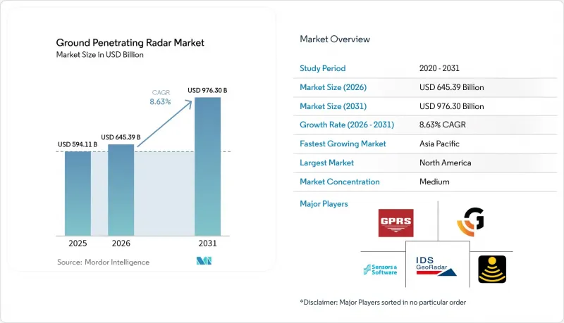
This report is Segmented by Offering (Equipment, Software, Services), Product Type (Handheld GPR, Cart-Based GPR, and More), Component (Control Unit, Antenna, Power Supply), Frequency Range (<500 MHz, and More), Application (Utility Detection, and More), End-User Industry (Construction and Infrastructure, and More), and Geography. The Market Forecasts are Provided in Terms of Value (USD).
Global Ground Penetrating Radar Market Trends and Insights
Rapid Expansion of Urban Underground Transportation Corridors in Asia
Asia's metro build-out from Beijing to Jakarta is fueling sustained purchases of network-ready GPR carts that couple live radar feeds with BIM dashboards. Contractors use continuous scans to guide tunnel-boring machines and avoid high-density utility clusters, reducing strike risk and schedule overruns. ESA's TruewaveGPR trials logged 50% faster surveys once GNSS and IMU telemetry were embedded. Government stimulus for climate-resilient infrastructure further underpins multi-year equipment demand.
Mandated Underground Utility Mapping Standards in North America and Europe
The Common Ground Alliance best-practice code now obliges electromagnetic verification before every dig, driving steady fleet renewals among locators and civil contractors. EU ultra-wideband harmonization delivers uniform frequency windows that simplify cross-border equipment logistics and reduce certification costs.
High Capital Cost and Limited Rental Ecosystem in Emerging Economies
Industrial-grade systems with AI processors retail well above USD 100,000, a hurdle for small contractors. Sparse rental fleets in Africa and parts of Latin America curb project-based adoption.
Other drivers and restraints analyzed in the detailed report include:
- Rising Adoption of High-Frequency Antenna Arrays for Concrete Imaging
- Integration of GPR with AI-Enabled Data Analytics Platforms
- Signal Attenuation in High-Conductivity Soils Limiting Depth Accuracy
For complete list of drivers and restraints, kindly check the Table Of Contents.
Segment Analysis
The equipment segment controlled 50.68% of the ground penetrating radar market in 2025, underscoring the capital-intensive role of transmit-receive hardware in survey workflows. Adopters upgrade to multichannel arrays that boost coverage speed without sacrificing depth resolution. Services, expanding at 9.05% CAGR, attract project owners seeking OPEX models and turnkey data interpretation. As AI modules migrate to edge processors inside control units, vendors bundle analytics subscriptions with hardware to build annuity revenue.
Services growth also reflects a widening skills gap; interpreting complex radar signatures now blends geophysics with data science. Fleet operators specializing in post-processing sell rapid-response scans to infrastructure owners that lack in-house expertise. Software-only providers exploit this shift, feeding classified traces into cloud-hosted neural networks that deliver automated layer picks and object tags within minutes.
Cart platforms held 41.35% revenue in 2025 by combining full ground coupling with ergonomic handling, a formula ideal for utility-locating and pavement surveys. Analytic dashboards turn live traces into color-coded depth slices viewable on-site. UAV payloads, although smaller, are scaling fastest at 10.9% CAGR. Mining firms fly radar beneath rotary-wing drones to map tailings-dam seepage paths, while defense teams use fixed-wing variants for border-tunnel sweeps. Despite lighter antennas limiting penetration versus carts, demand rises where ground access is restricted or hazardous.
Hybrid concepts are emerging: detachable sleds that clip to a drone harness for transit then pivot to wheel-based scanning once on site. This modularity lengthens flight endurance and maintains depth capability, hinting at future convergence of airborne and terrestrial designs.
Complete Report Scope:
- By Offering
- Equipment
- Software
- Services
- By Product Type
- Handheld GPR
- Cart-Based GPR
- Vehicle-Mounted GPR
- UAV/Drone-Mounted GPR
- By Component
- Control Unit
- Antenna
- Power Supply
- By Frequency Range
- <500 MHz
- 500 - 1000 MHz
- > 1000 MHz
- By Application
- Utility Detection
- Concrete Investigation
- Municipal Inspection
- Forensics and Archaeology
- Transportation Infrastructure
- Geotechnical and Environment
- Disaster Inspection
- Law Enforcement and Military
- By End-User Industry
- Construction and Infrastructure
- Oil and Gas / Mining
- Environmental and Agriculture
- Defense and Security
- Academic and Research
- By Geography
- North America
- United States
- Canada
- Mexico
- South America
- Brazil
- Argentina
- Rest of South America
- Europe
- Germany
- United Kingdom
- France
- Italy
- Spain
- Rest of Europe
- Asia-Pacific
- China
- Japan
- India
- South Korea
- Southeast Asia
- Rest of Asia-Pacific
- Middle East and Africa
- South Africa
- Saudi Arabia
- Nigeria
- United Arab Emirates
- Rest of Middle East and Africa
- North America
Geography Analysis
North America led with 33.45% revenue in 2025 thanks to stringent Common Ground Alliance rules that mandate subsurface verification and to steady replacement cycles among fleet operators. State-backed infrastructure grants covering broadband, EV plants, and grid upgrades ensure a deep pipeline of scanning projects. Regional vendors couple radar with AI software to export turnkey offerings globally.
Asia-Pacific posts the highest regional CAGR at 8.7%. Mega-metro rail lines in China, India, and Southeast Asia require 24/7 radar monitoring during excavation. Smart-city programs layer radar outputs into digital twins of underground utility corridors, steering maintenance crews proactively. Japan and South Korea champion drone-based arrays for landslide-prone mountain routes, driving early adoption of lightweight antenna tech.
Europe retains healthy demand under harmonized UWB regulations that smooth certification workflows. Heritage-site managers in Italy and Greece deploy high-frequency rigs to audit cathedral foundations without drilling cores. Defense sensor contracts surged in 2025 as regional tensions prompted larger counter-measure budgets, benefitting suppliers of radar altimeters and electronic-warfare payloads.
Latin America, the Middle East, and Africa remain under-penetrated yet opportunity-rich. Brazil's power-grid expansion and Saudi Arabia's giga-projects, for example, include sizable allocations for underground-utility mapping. The constraint remains equipment affordability and interpreter availability, spurring interest in pay-per-scan service models.
- IDS GeoRadar
- Sensors and Software Inc.
- Guideline Geo AB
- Chemring Group PLC
- GSSI (Geophysical Survey Systems Inc.)
- Ground Penetrating Radar Systems LLC
- Geoscanners AB
- Pipehawk PLC
- Utsi Electronics Ltd.
- Hilti Corporation
- Hexagon AB
- US Radar Inc.
- Radiodetection Ltd.
- Penetradar Corporation
- MALA GPR
- Leica Geosystems AG
- Trimble Inc.
- ImpulseRadar Sweden AB
- 4M Analytics Ltd.
- TransTech Systems Inc.
Additional Benefits:
- The market estimate (ME) sheet in Excel format
- 3 months of analyst support
TABLE OF CONTENTS
1 INTRODUCTION
- 1.1 Study Assumptions and Market Definition
- 1.2 Scope of the Study
2 RESEARCH METHODOLOGY
3 EXECUTIVE SUMMARY
4 MARKET LANDSCAPE
- 4.1 Market Overview
- 4.2 Market Drivers
- 4.2.1 Rapid Expansion of Urban Underground Transportation Corridors in Asia
- 4.2.2 Mandated Underground Utility Mapping Standards in North America and Europe
- 4.2.3 Rising Adoption of High-Frequency Antenna Arrays for Concrete Imaging
- 4.2.4 Integration of GPR with AI-Enabled Data Analytics Platforms
- 4.2.5 Growing Demand for Non-Invasive Sub-surface Mapping in Renewable Energy Projects
- 4.2.6 Increasing Deployment of UAV-Mounted GPR for Remote and Hazardous Terrains
- 4.3 Market Restraints
- 4.3.1 High Capital Cost and Limited Rental Ecosystem in Emerging Economies
- 4.3.2 Signal Attenuation in High-Conductivity Soils Limiting Depth Accuracy
- 4.3.3 Scarcity of Skilled GPR Data Interpreters Globally
- 4.3.4 Regulatory Restrictions on Electromagnetic Emissions in EU and Japan
- 4.4 Value / Supply-Chain Analysis
- 4.5 Regulatory and Technological Outlook
- 4.5.1 Technology Snapshot
- 4.6 Porter's Five Forces Analysis
- 4.6.1 Threat of New Entrants
- 4.6.2 Bargaining Power of Buyers/Consumers
- 4.6.3 Bargaining Power of Suppliers
- 4.6.4 Threat of Substitute Products
- 4.6.5 Intensity of Competitive Rivalry
- 4.7 Investment Analysis
5 MARKET SIZE AND GROWTH FORECASTS (VALUE)
- 5.1 By Offering
- 5.1.1 Equipment
- 5.1.2 Software
- 5.1.3 Services
- 5.2 By Product Type
- 5.2.1 Handheld GPR
- 5.2.2 Cart-Based GPR
- 5.2.3 Vehicle-Mounted GPR
- 5.2.4 UAV/Drone-Mounted GPR
- 5.3 By Component
- 5.3.1 Control Unit
- 5.3.2 Antenna
- 5.3.3 Power Supply
- 5.4 By Frequency Range
- 5.4.1 < 500 MHz
- 5.4.2 500 - 1000 MHz
- 5.4.3 > 1000 MHz
- 5.5 By Application
- 5.5.1 Utility Detection
- 5.5.2 Concrete Investigation
- 5.5.3 Municipal Inspection
- 5.5.4 Forensics and Archaeology
- 5.5.5 Transportation Infrastructure
- 5.5.6 Geotechnical and Environment
- 5.5.7 Disaster Inspection
- 5.5.8 Law Enforcement and Military
- 5.6 By End-User Industry
- 5.6.1 Construction and Infrastructure
- 5.6.2 Oil and Gas / Mining
- 5.6.3 Environmental and Agriculture
- 5.6.4 Defense and Security
- 5.6.5 Academic and Research
- 5.7 By Geography
- 5.7.1 North America
- 5.7.1.1 United States
- 5.7.1.2 Canada
- 5.7.1.3 Mexico
- 5.7.2 South America
- 5.7.2.1 Brazil
- 5.7.2.2 Argentina
- 5.7.2.3 Rest of South America
- 5.7.3 Europe
- 5.7.3.1 Germany
- 5.7.3.2 United Kingdom
- 5.7.3.3 France
- 5.7.3.4 Italy
- 5.7.3.5 Spain
- 5.7.3.6 Rest of Europe
- 5.7.4 Asia-Pacific
- 5.7.4.1 China
- 5.7.4.2 Japan
- 5.7.4.3 India
- 5.7.4.4 South Korea
- 5.7.4.5 Southeast Asia
- 5.7.4.6 Rest of Asia-Pacific
- 5.7.5 Middle East and Africa
- 5.7.5.1 South Africa
- 5.7.5.2 Saudi Arabia
- 5.7.5.3 Nigeria
- 5.7.5.4 United Arab Emirates
- 5.7.5.5 Rest of Middle East and Africa
- 5.7.1 North America
6 COMPETITIVE LANDSCAPE
- 6.1 Market Concentration
- 6.2 Strategic Moves
- 6.3 Market Share Analysis
- 6.4 Company Profiles (includes Global level Overview, Market level overview, Core Segments, Financials as available, Strategic Information, Market Rank/Share for key companies, Products & Services, and Recent Developments)
- 6.4.1 IDS GeoRadar
- 6.4.2 Sensors and Software Inc.
- 6.4.3 Guideline Geo AB
- 6.4.4 Chemring Group PLC
- 6.4.5 GSSI (Geophysical Survey Systems Inc.)
- 6.4.6 Ground Penetrating Radar Systems LLC
- 6.4.7 Geoscanners AB
- 6.4.8 Pipehawk PLC
- 6.4.9 Utsi Electronics Ltd.
- 6.4.10 Hilti Corporation
- 6.4.11 Hexagon AB
- 6.4.12 US Radar Inc.
- 6.4.13 Radiodetection Ltd.
- 6.4.14 Penetradar Corporation
- 6.4.15 MALA GPR
- 6.4.16 Leica Geosystems AG
- 6.4.17 Trimble Inc.
- 6.4.18 ImpulseRadar Sweden AB
- 6.4.19 4M Analytics Ltd.
- 6.4.20 TransTech Systems Inc.
7 MARKET OPPORTUNITIES AND FUTURE OUTLOOK
- 7.1 White-Space and Unmet-Need Assessment

