
PUBLISHER: MarketsandMarkets | PRODUCT CODE: 1823728

PUBLISHER: MarketsandMarkets | PRODUCT CODE: 1823728
Digital Map Market by Solution, Use Case - Global Forecast to 2030
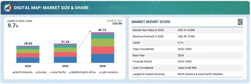
The digital map market is anticipated to witness a compound annual growth rate (CAGR) of 9.7% over the forecast period, reaching USD 49.73 billion by 2030 from an estimated USD 31.24 billion in 2025. The digital map market is growing as retailers and marketers increasingly use location analytics to choose store sites, target customers, and improve logistics. At the same time, governments and enterprises are demanding advanced mapping of infrastructure such as telecom, power, and water networks to support planning and maintenance.
| Scope of the Report | |
|---|---|
| Years Considered for the Study | 2020-2030 |
| Base Year | 2024 |
| Forecast Period | 2025-2030 |
| Units Considered | USD (Million) |
| Segments | Offering, Mapping Location, Mapping Type, Functional Use Case, Industry Vertical, and Region |
| Regions covered | North America, Europe, Asia Pacific, Middle East & Africa, and Latin America |
However, a key restraint for vendors is that success in fast-growing areas like autonomous vehicles and logistics often depends heavily on partnerships with automotive and transport players, creating dependency risks.
"Outdoor mapping leading mobility and infrastructure innovation"
The outdoor mapping location segment is estimated to hold the major share of the digital map market in 2025, as most navigation, logistics, and mobility services rely heavily on outdoor spatial data. Outdoor maps are the backbone of applications such as road navigation, public transportation planning, and last-mile delivery, all of which are growing rapidly with the expansion of e-commerce and ride-hailing platforms. The demand for accurate outdoor mapping is also being fueled by the rise of autonomous vehicles and drones, which require high-definition, constantly updated outdoor maps to operate safely in real-world conditions. Governments and municipalities are increasingly digitizing roads, utilities, and public spaces to support smart city initiatives, boosting the adoption of outdoor mapping. Additionally, outdoor maps play a critical role in sectors like agriculture, forestry, mining, and energy, where geospatial data is used for monitoring and resource management across vast areas. The use of GPS-enabled smartphones and connected devices has made outdoor mapping indispensable for everyday consumer navigation and location-based services. Continuous improvements in satellite imaging, aerial surveys, and sensor integration are further enhancing the accuracy and usability of outdoor maps
"Advances in satellite imaging and remote sensing fuel 2D mapping type segment"
The 2D mapping type segment is estimated to hold the largest share of the digital map market in 2025 because of its widespread use across both consumer and enterprise applications. Two-dimensional maps form the foundation of most navigation systems, mobile applications, and online platforms, making them the most familiar and accessible mapping format. They are widely used in smartphones, GPS devices, and web-based applications to provide route guidance, location searches, and area overviews. In industries such as logistics, retail, and travel, 2D maps continue to be the preferred choice for tracking assets, optimizing delivery routes, and planning customer engagement due to their simplicity and lower processing requirements compared to 3D maps. Governments and public agencies also rely heavily on 2D maps for tasks like land records, infrastructure planning, and urban management, further cementing their role in large-scale adoption. Advances in satellite imaging and remote sensing have significantly improved the accuracy and detail of 2D maps, making them more reliable for real-time applications. In addition, integration with cloud platforms and APIs allows businesses to easily embed 2D maps into their digital services at scale. The combination of familiarity, cost efficiency, and broad compatibility ensures that 2D mapping will maintain its dominance in market share by 2025.
"Asia Pacific to witness rapid market growth fueled by innovation and emerging technologies, while North America leads in market size"
Asia Pacific is expected to be the fastest-growing market for digital maps during 2025-2030, driven by rapid urbanization, large-scale infrastructure development, and government-backed smart city initiatives. Countries such as China, India, Japan, and South Korea are making significant investments in geospatial technologies, satellite imaging, and 5G-enabled location services. The rise of e-commerce, ride-hailing platforms, and delivery logistics across the region further accelerates demand for real-time and high-definition mapping solutions. In parallel, the region is also witnessing strong adoption of drones, robotics, and autonomous vehicle trials, all of which require advanced digital mapping. On the other hand, North America is estimated to hold the largest market share in 2025 due to its early adoption of mapping technologies, mature ecosystem of digital map vendors, and high usage across sectors such as automotive, defense, logistics, and utilities. The region benefits from widespread penetration of connected devices, early rollout of autonomous mobility solutions, and continuous advancements in GPS and sensor integration. Strong collaboration between technology providers, transport players, and enterprises ensures that digital maps are deeply embedded in everyday business operations. This makes North America the leading region in terms of current market size, while Asia Pacific emerges as the fastest-growing region during the forecast period.
Breakdown of Primaries
In-depth interviews were conducted with chief executive officers (CEOs), innovation and technology directors, system integrators, and executives from various key organizations operating in the digital map market.
- By Company: Tier I - 55%, Tier II - 25%, and Tier III - 20%
- By Designation: Directors - 50%, Managers - 30%, and others - 20%
- By Region: North America - 40%, Europe - 35%, Asia Pacific - 20%, RoW (Middle East & Africa, and Latin America - 5%
The report includes the study of key players offering digital map solutions and services. It profiles major vendors in the digital map market. The major players in the digital map market include Google (US), Esri (US), Apple (US), TomTom (Netherlands), Here Technologies (Netherlands), Maxar Technologies (US), Lightbox (US), Nearmap (Australia), Carto (US), ServiceNow (US), Mappls (India), Microsoft (US), Inrix (US), Inpixon (US), Maptive (US), Mapbox (US), GIS Cloud (UK), Teledyne Technologies (US), Blue Marble Geographies (US), Planet Labs (US), Hexagon (Sweden), Emapa (Poland), Dabeeo (South Korea), Caliper Corporation (US), GeoVerra (Canada), Privateer (US), Digimap (US), MapQuest (US), IndoorAtlas (Finland), Mapsted (canada), Mapidea (Portugal), Geocento (UK), Geospin (Germany), Jawg Maps (France), Barikoi (Bangladesh), EasyMapMaker (US), BatchGeo (US), Espatial (Ireland), Mapline (US), Scribble Maps (US), SuperMap (China), Bentley Systems (US), and Genesys (India).
Research Coverage
This research report covers the digital map market, which has been segmented based on Offering, Mapping Location, Mapping Type, Functional Use case, and Industry vertical. The offering segment consists of offering type (Solutions and Services), deployment mode (Cloud and On-premises), and Scale (Small-scale Map and Large-scale Map). The mapping location segment consists Indoor and Outdoor. The mapping type segment includes 2D, 3D, and 4D, and the functional use case segment consists of Navigation Maps, Thematic Maps, Satellite Maps, and Traffic Maps. The industry vertical segment consists of Government & Defense, Real Estate & Construction, Transportation & Logistics, Automotive, Telecommunications, Retail & Consumer Goods, Travel & Tourism, Manufacturing, BFSI, Energy & Utilities, Agriculture & Forestry, and Other Industry Verticals (IT & ITes, Healthcare & Life Sciences, and Education). The regional analysis of the digital map market covers North America, Europe, Asia Pacific, the Middle East & Africa (MEA), and Latin America.
Key Benefits of Buying the Report
The report would provide the market leaders/new entrants in this market with information on the closest approximations of the revenue numbers for the overall digital map market and its subsegments. It would help stakeholders understand the competitive landscape and gain more insights to position their business and plan suitable go-to-market strategies. It also helps stakeholders understand the market's pulse and provides information on key market drivers, restraints, challenges, and opportunities.
The report provides insights on the following pointers:
Analysis of key drivers (Advancing 3D terrain and city modeling software, scaling location-based personalization engines, AI-driven integration of live geospatial mapping, and predictive traffic management solutions gaining momentum), restraints (Interoperability gaps in GIS and mapping platforms and latency challenges in real-time traffic monitoring), opportunities (Emerging style marketplaces and white-label map studios, verified store-level geotargeting and attribution, and unlocking spatial commerce and 4D consumer journeys), and challenges (High dependency on external data sources and intensive processing needs for real-time 3D and AR navigation).
- Product Development/Innovation: Detailed insights on upcoming technologies, research & development activities, and new product & service launches in the digital map market.
- Market Development: Comprehensive information about lucrative markets - the report analyses the digital map market across varied regions.
- Market Diversification: Exhaustive information about new products & services, untapped geographies, recent developments, and investments in the digital map market.
- Competitive Assessment: In-depth assessment of market shares, growth strategies and offerings of leading players like Google (US), Esri (US), Apple (US), TomTom (Netherlands), Here Technologies (Netherlands), Maxar Technologies (US), Lightbox (US), Nearmap (Australia), Carto (US), ServiceNow (US), Mappls (India), Microsoft (US), Inrix (US), Inpixon (US), Maptive (US), Mapbox (US), GIS Cloud (UK), Teledyne Technologies (US), Blue Marble Geographies (US), Planet Labs (US), Hexagon (Sweden), Emapa (Poland), Dabeeo (South Korea), Caliper Corporation (US), Geoverra (Canada), Privateer (US), Digimap (US), MapQuest (US), IndoorAtlas (Finland), Mapsted (canada), Mapidea (Portugal), Geocento (UK), Geospin (Germany), Jawg Maps (France), Barikoi (Bangladesh), EasyMapMaker (US), BatchGeo (US), Espatial (Ireland), Mapline (US), Scribble Maps (US), SuperMap (China), Bentley Systems (US), and Genesys (India), among others, in the digital map market. The report also helps stakeholders understand the pulse of the digital map market and provides them with information on key market drivers, restraints, challenges, and opportunities.
TABLE OF CONTENTS
1 INTRODUCTION
- 1.1 STUDY OBJECTIVES
- 1.2 MARKET DEFINITION
- 1.2.1 INCLUSIONS AND EXCLUSIONS
- 1.3 STUDY SCOPE
- 1.3.1 MARKET SEGMENTATION
- 1.3.2 YEARS CONSIDERED
- 1.4 CURRENCY CONSIDERED
- 1.5 STAKEHOLDERS
- 1.6 SUMMARY OF CHANGES
2 RESEARCH METHODOLOGY
- 2.1 RESEARCH DATA
- 2.1.1 SECONDARY DATA
- 2.1.2 PRIMARY DATA
- 2.1.2.1 List of primary participants
- 2.1.2.2 Breakdown of primaries
- 2.1.2.3 Key industry insights
- 2.2 MARKET BREAKUP AND DATA TRIANGULATION
- 2.3 MARKET SIZE ESTIMATION
- 2.3.1 TOP-DOWN APPROACH
- 2.3.2 BOTTOM-UP APPROACH
- 2.4 MARKET FORECAST
- 2.5 RESEARCH ASSUMPTIONS
- 2.6 RESEARCH LIMITATIONS
3 EXECUTIVE SUMMARY
4 PREMIUM INSIGHTS
- 4.1 ATTRACTIVE OPPORTUNITIES FOR PLAYERS IN DIGITAL MAP MARKET
- 4.2 DIGITAL MAP MARKET: MAPPING TYPE
- 4.3 NORTH AMERICA: DIGITAL MAP MARKET, BY FUNCTIONAL USE CASE AND INDUSTRY VERTICAL
- 4.4 DIGITAL MAP MARKET: BY REGION
5 MARKET OVERVIEW AND INDUSTRY TRENDS
- 5.1 INTRODUCTION
- 5.2 MARKET DYNAMICS
- 5.2.1 DRIVERS
- 5.2.1.1 Advancing 3D terrain and city modeling software
- 5.2.1.2 Scaling location-based personalization engines
- 5.2.1.3 Rise of AI-powered real-time geospatial mapping for dynamic decision-making
- 5.2.1.4 Growing adoption of predictive traffic management solutions
- 5.2.2 RESTRAINTS
- 5.2.2.1 Interoperability gaps in GIS and mapping platforms
- 5.2.2.2 Latency issues in real-time traffic monitoring
- 5.2.3 OPPORTUNITIES
- 5.2.3.1 Emerging style marketplaces and white-label map studios
- 5.2.3.2 Verified store-level geotargeting and attribution
- 5.2.3.3 Unlocking spatial commerce and 4D consumer journeys
- 5.2.4 CHALLENGES
- 5.2.4.1 High dependency on external data sources
- 5.2.4.2 Intensive processing needs for real-time 3D and AR navigation
- 5.2.1 DRIVERS
- 5.3 IMPACT OF GENERATIVE AI ON DIGITAL MAP MARKET
- 5.3.1 AUTOMATED MAP CONTENT GENERATION
- 5.3.2 DYNAMIC ROUTE OPTIMIZATION
- 5.3.3 3D CITY AND TERRAIN MODELING
- 5.3.4 PERSONALIZED LOCATION-BASED SERVICES
- 5.3.5 REAL-TIME TRAFFIC PREDICTION
- 5.3.6 THEMATIC AND CUSTOM MAPS CREATION
- 5.4 EVOLUTION OF DIGITAL MAP
- 5.5 SUPPLY CHAIN ANALYSIS
- 5.6 ECOSYSTEM ANALYSIS
- 5.6.1 GIS PLATFORM/GIS SYSTEM PROVIDERS
- 5.6.2 GEOSPATIAL INTELLIGENCE TOOL PROVIDERS
- 5.6.3 LOCATION ANALYTICS SOLUTION PROVIDERS
- 5.6.4 INDOOR MAPPING AND POSITIONING TOOL PROVIDERS
- 5.6.5 NAVIGATION AND ROUTING PLATFORM PROVIDERS
- 5.6.6 MAPPING DATA AND CONTENT PLATFORM PROVIDERS
- 5.6.7 OTHER SOLUTION PROVIDERS
- 5.7 IMPACT OF 2025 US TARIFF - DIGITAL MAP MARKET
- 5.7.1 INTRODUCTION
- 5.7.2 KEY TARIFF RATES
- 5.7.3 PRICE IMPACT ANALYSIS
- 5.7.3.1 Strategic shifts and emerging trends
- 5.7.4 IMPACT ON COUNTRY/REGION
- 5.7.4.1 US
- 5.7.4.2 Asia Pacific
- 5.7.4.3 Europe
- 5.7.5 IMPACT ON END-USE INDUSTRIES
- 5.7.5.1 BFSI
- 5.7.5.2 Government & defense
- 5.7.5.3 Transportation & logistics
- 5.7.5.4 Manufacturing
- 5.7.5.5 Real estate & construction
- 5.7.5.6 Automotive
- 5.7.5.7 Telecommunications
- 5.7.5.8 Retail & consumer goods
- 5.7.5.9 Travel & tourism
- 5.7.5.10 Energy & utilities
- 5.7.5.11 Agriculture & forestry
- 5.8 INVESTMENT AND FUNDING SCENARIO
- 5.9 CASE STUDY ANALYSIS
- 5.9.1 AETHER AND NEARMAP DELIVER AI-POWERED LOCATION INTELLIGENCE FOR CONTRACTORS
- 5.9.2 TOLL BROTHERS ENHANCES LAND ACQUISITION WITH LIGHTBOX GIS MAPPING
- 5.9.3 TETON COUNTY BOOSTS 911 ACCURACY WITH ESRI GEOCODING COLLABORATION
- 5.9.4 PLANET LABS AND SHRIMPL MODERNIZE AQUACULTURE WITH SATELLITE DATA AND AI
- 5.9.5 RAPIDO BUILDS TRUST AND EFFICIENCY WITH GOOGLE MAPS PLATFORM
- 5.10 TECHNOLOGY ANALYSIS
- 5.10.1 KEY TECHNOLOGIES
- 5.10.1.1 Global navigation satellite systems (GNSS)
- 5.10.1.2 Aerial and satellite imagery
- 5.10.1.3 LiDAR (airborne and terrestrial)
- 5.10.1.4 Photogrammetry/structure-from-motion (SFM)
- 5.10.1.5 HD and 3D mapping engines
- 5.10.1.6 Simultaneous localization and mapping (SLAM)
- 5.10.1.7 GIS
- 5.10.1.8 Geocoding/reverse geocoding
- 5.10.2 COMPLEMENTARY TECHNOLOGIES
- 5.10.2.1 Cloud computing
- 5.10.2.2 Artificial intelligence (AI)
- 5.10.2.3 Edge computing
- 5.10.2.4 Computer vision
- 5.10.2.5 5G and connectivity
- 5.10.2.6 Indoor positioning technologies (BLE, UWB, Wi-Fi RTT, magnetic)
- 5.10.3 ADJACENT TECHNOLOGIES
- 5.10.3.1 Augmented reality (AR) and virtual reality (VR)
- 5.10.3.2 Autonomous vehicles and ADAS
- 5.10.3.3 Digital twins and urban simulation
- 5.10.3.4 Internet of Things (IoT)
- 5.10.1 KEY TECHNOLOGIES
- 5.11 REGULATORY LANDSCAPE
- 5.11.1 REGULATORY BODIES, GOVERNMENT AGENCIES, AND OTHER ORGANIZATIONS
- 5.11.2 REGULATIONS
- 5.11.2.1 North America
- 5.11.2.1.1 US Geospatial Data Act (2018)
- 5.11.2.1.2 US National Map Policy (USGS)
- 5.11.2.1.3 Canada's Geospatial Data Policy (GeoBase Initiative)
- 5.11.2.1.4 Artificial Intelligence and Data Act (AIDA) (Canada)
- 5.11.2.1.5 US FCC Location Accuracy Requirements
- 5.11.2.2 Europe
- 5.11.2.2.1 European Union (EU) - Artificial Intelligence Act (AIA)
- 5.11.2.2.2 General Data Protection Regulation (Europe)
- 5.11.2.2.3 EU INSPIRE Directive (2007)
- 5.11.2.2.4 UK Ordnance Survey Public Data Release Policy
- 5.11.2.2.5 Germany's Federal Spatial Data Infrastructure (GDI-DE)
- 5.11.2.3 Asia Pacific
- 5.11.2.3.1 Interim Administrative Measures for Generative Artificial Intelligence Services (China)
- 5.11.2.3.2 National AI Strategy (Singapore)
- 5.11.2.3.3 India - Geospatial Data Policy 2021
- 5.11.2.3.4 China - Surveying and Mapping Law
- 5.11.2.3.5 Japan - Basic Act on the Advancement of Utilizing Geospatial Information (2007)
- 5.11.2.3.6 Australia - Location Information Privacy Guidelines
- 5.11.2.4 Middle East & Africa
- 5.11.2.4.1 National Strategy for Artificial Intelligence (UAE)
- 5.11.2.4.2 National Artificial Intelligence Strategy (Qatar)
- 5.11.2.4.3 United Arab Emirates - National Geospatial Data Infrastructure (NGDI) Policy
- 5.11.2.4.4 Saudi Arabia - General Authority for Survey and Geospatial Information (GASGI) Regulations
- 5.11.2.4.5 South Africa - Spatial Data Infrastructure Act (2003)
- 5.11.2.4.6 Qatar - National Geospatial Center Directives
- 5.11.2.5 Latin America
- 5.11.2.5.1 Santiago Declaration (Chile)
- 5.11.2.5.2 Brazilian Artificial Intelligence Strategy (EBIA)
- 5.11.2.1 North America
- 5.12 PATENT ANALYSIS
- 5.12.1 METHODOLOGY
- 5.12.2 PATENTS FILED, BY DOCUMENT TYPE
- 5.12.3 INNOVATION AND PATENT APPLICATIONS
- 5.13 PRICING ANALYSIS
- 5.13.1 AVERAGE SELLING PRICE OF OFFERINGS, BY KEY PLAYER, 2025
- 5.13.2 AVERAGE SELLING PRICE, BY FUNCTIONAL USE CASE, 2025
- 5.14 KEY CONFERENCES AND EVENTS, 2025-2026
- 5.15 PORTER'S FIVE FORCES ANALYSIS
- 5.15.1 THREAT OF NEW ENTRANTS
- 5.15.2 THREAT OF SUBSTITUTES
- 5.15.3 BARGAINING POWER OF SUPPLIERS
- 5.15.4 BARGAINING POWER OF BUYERS
- 5.15.5 INTENSITY OF COMPETITION RIVALRY
- 5.16 KEY STAKEHOLDERS AND BUYING CRITERIA
- 5.16.1 KEY STAKEHOLDERS IN BUYING PROCESS
- 5.16.2 BUYING CRITERIA
- 5.17 TRENDS/DISRUPTIONS IMPACTING CUSTOMER BUSINESS
- 5.18 INTELLIGENCE MAPPING FOR LOGISTICS: PREDICTIVE ETAS & LIVE ROUTING
- 5.18.1 OPTIMIZING LOGISTICS WITH PREDICTIVE ESTIMATED TIME OF ARRIVAL (ETA)
- 5.18.2 ENABLING LIVE ROUTING FOR DYNAMIC FLEET MANAGEMENT
- 5.18.3 DRIVING STRATEGIC DECISION-MAKING WITH GEOSPATIAL INSIGHTS
- 5.19 UNIFIED AI MAPPING FRAMEWORKS FOR SOFTWARE-DEFINED VEHICLES
- 5.19.1 REVOLUTIONIZING SOFTWARE-DEFINED VEHICLE (SDV) FUNCTIONALITY
- 5.19.2 ENHANCING COMPETITIVE DIFFERENTIATION AND SCALABILITY
- 5.19.3 DRIVING AI-POWERED PERSONALIZATION AND MARKET EXPANSION
6 DIGITAL MAP MARKET, BY OFFERING
- 6.1 INTRODUCTION
- 6.1.1 DRIVERS: DIGITAL MAP MARKET, BY OFFERING
- 6.2 TYPE
- 6.2.1 SOLUTIONS
- 6.2.1.1 GIS platforms/GIS systems
- 6.2.1.1.1 Expanding role of GIS platforms in enterprise decision-making
- 6.2.1.2 Location analytics solutions
- 6.2.1.2.1 Driving business insights with location analytics solutions
- 6.2.1.3 Geospatial intelligence tools
- 6.2.1.3.1 Enhancing decision-making with geospatial intelligence tools
- 6.2.1.4 Mapping data and content platforms
- 6.2.1.4.1 Rising demand for mapping data and content platforms
- 6.2.1.5 Navigation and routing platforms
- 6.2.1.5.1 Strengthening mobility through navigation and routing platforms
- 6.2.1.6 Indoor mapping and positioning tools
- 6.2.1.6.1 Transforming indoor experiences with mapping and positioning tools
- 6.2.1.7 Other solutions
- 6.2.1.1 GIS platforms/GIS systems
- 6.2.2 SERVICES
- 6.2.2.1 Professional services
- 6.2.2.1.1 Bridging technology and business outcomes through professional services
- 6.2.2.1.2 Consulting & advisory
- 6.2.2.1.3 Deployment & integration
- 6.2.2.1.4 Data collection & surveying
- 6.2.2.1.5 Map updating & maintenance
- 6.2.2.1.6 Support & training
- 6.2.2.2 Managed services
- 6.2.2.2.1 Driving efficiency through managed services
- 6.2.2.1 Professional services
- 6.2.1 SOLUTIONS
- 6.3 DEPLOYMENT MODE
- 6.3.1 CLOUD
- 6.3.1.1 Fueling flexible and scalable mapping adoption through cloud deployment
- 6.3.2 ON-PREMISES
- 6.3.2.1 Ensuring security and data control with on-premises deployment
- 6.3.1 CLOUD
- 6.4 SCALE
- 6.4.1 SMALL-SCALE MAPS
- 6.4.1.1 Small-scale maps supporting detailed visualization needs
- 6.4.2 LARGE-SCALE MAPS
- 6.4.2.1 Large-scale maps driving precision and operational efficiency
- 6.4.1 SMALL-SCALE MAPS
7 DIGITAL MAP MARKET, BY MAPPING TYPE
- 7.1 INTRODUCTION
- 7.1.1 DRIVERS: DIGITAL MAP MARKET, BY MAPPING TYPE
- 7.2 2D
- 7.2.1 DRIVING RELIABLE NAVIGATION AND ROUTE OPTIMIZATION
- 7.3 3D
- 7.3.1 POWERING SMART CITIES AND IMMERSIVE EXPERIENCES
- 7.4 4D
- 7.4.1 ENABLING PREDICTIVE INSIGHTS AND REAL-TIME SIMULATIONS
8 DIGITAL MAP MARKET, BY MAPPING LOCATION
- 8.1 INTRODUCTION
- 8.1.1 DRIVERS: DIGITAL MAP MARKET, BY MAPPING LOCATION
- 8.2 INDOOR
- 8.2.1 INDOOR MAPPING TO GAIN TRACTION AS IT ACHIEVES OPERATIONAL EFFICIENCY AND CUSTOMER SATISFACTION
- 8.2.2 INDOOR NAVIGATION & WAYFINDING
- 8.2.3 INDOOR POSITIONING SYSTEMS (IPS)
- 8.2.4 INDOOR ASSET & RESOURCE TRACKING
- 8.2.5 INDOOR FACILITY MAPPING
- 8.2.6 INDOOR SAFETY & EMERGENCY MAPPING
- 8.3 OUTDOOR
- 8.3.1 OUTDOOR MAPPING EMPOWERS APPLICATIONS ACROSS LAND MANAGEMENT AND INFRASTRUCTURE DEVELOPMENT
- 8.3.2 TOPOGRAPHIC MAPPING
- 8.3.3 THEMATIC MAPPING
- 8.3.4 NAVIGATIONAL MAPPING
- 8.3.5 CADASTRAL & PARCEL MAPPING
- 8.3.6 SATELLITE & AERIAL MAPPING
- 8.3.7 UTILITY & INFRASTRUCTURE MAPPING
9 DIGITAL MAP MARKET, BY FUNCTIONAL USE CASE
- 9.1 INTRODUCTION
- 9.1.1 DRIVERS: DIGITAL MAP MARKET, BY FUNCTIONAL USE CASE
- 9.2 NAVIGATION MAPS
- 9.2.1 TURN-BY-TURN NAVIGATION MAPS
- 9.2.1.1 Supporting real-time traffic and road updates
- 9.2.2 PEDESTRIAN NAVIGATION MAPS
- 9.2.2.1 Enhancing walkability and smart city mobility
- 9.2.3 PUBLIC TRANSPORT MAPS
- 9.2.3.1 Improving commuter experience and route planning
- 9.2.1 TURN-BY-TURN NAVIGATION MAPS
- 9.3 THEMATIC MAPS
- 9.3.1 DEMOGRAPHIC MAPS
- 9.3.1.1 Enhancing location-based marketing strategies
- 9.3.2 ENVIRONMENTAL MAPS
- 9.3.2.1 Driving disaster preparedness and response planning
- 9.3.3 ECONOMIC MAPS
- 9.3.3.1 Driving infrastructure investments and growth planning
- 9.3.4 HEALTH MAPS
- 9.3.4.1 Enabling emergency response and epidemic preparedness
- 9.3.1 DEMOGRAPHIC MAPS
- 9.4 SATELLITE MAPS
- 9.4.1 AERIAL IMAGERY
- 9.4.1.1 Driving precision agriculture and land monitoring
- 9.4.2 REMOTE SENSING IMAGERY
- 9.4.2.1 Enabling resource exploration and management
- 9.4.3 MULTISPECTRAL IMAGERY
- 9.4.3.1 Driving crop monitoring and agricultural productivity
- 9.4.4 RADAR IMAGERY
- 9.4.4.1 Supporting all-weather defense and security operations
- 9.4.1 AERIAL IMAGERY
- 9.5 TRAFFIC MAPS
- 9.5.1 CONGESTION HEAT MAPS
- 9.5.1.1 Enabling infrastructure and road planning decisions
- 9.5.2 INCIDENT MAPS
- 9.5.2.1 Supporting emergency response and public safety
- 9.5.3 PREDICTIVE TRAFFIC MAPS
- 9.5.3.1 Driving proactive commuter route decisions
- 9.5.4 ALTERNATIVE ROUTE MAPS
- 9.5.4.1 Supporting faster and reliable travel choices
- 9.5.1 CONGESTION HEAT MAPS
10 DIGITAL MAP MARKET, BY INDUSTRY VERTICAL
- 10.1 INTRODUCTION
- 10.1.1 DRIVERS: DIGITAL MAP MARKET, BY INDUSTRY VERTICAL
- 10.2 GOVERNMENT & DEFENSE
- 10.2.1 DIGITAL MAPS STRENGTHENING NATIONAL SECURITY AND EMERGENCY RESPONSE
- 10.3 REAL ESTATE & CONSTRUCTION
- 10.3.1 DIGITAL MAPS POWERING SMART INFRASTRUCTURE AND URBAN DEVELOPMENT
- 10.4 TRANSPORTATION & LOGISTICS
- 10.4.1 DIGITAL MAPS DRIVING ROUTE OPTIMIZATION AND SUPPLY CHAIN EFFICIENCY
- 10.5 AUTOMOTIVE
- 10.5.1 DIGITAL MAPS ENABLING AUTONOMOUS DRIVING AND CONNECTED MOBILITY
- 10.6 TELECOMMUNICATIONS
- 10.6.1 DIGITAL MAPS SUPPORTING NETWORK PLANNING AND 5G ROLLOUT
- 10.7 RETAIL & CONSUMER GOODS
- 10.7.1 DIGITAL MAPS ENHANCING CUSTOMER TARGETING AND STORE OPTIMIZATION
- 10.8 TRAVEL & TOURISM
- 10.8.1 DIGITAL MAPS DELIVERING IMMERSIVE TRAVEL AND SEAMLESS NAVIGATION
- 10.9 MANUFACTURING
- 10.9.1 DIGITAL MAPS OPTIMIZING PLANT OPERATIONS AND INDUSTRIAL SUPPLY CHAINS
- 10.10 BFSI
- 10.10.1 DIGITAL MAPS SUPPORTING RISK ASSESSMENT AND BRANCH EXPANSION
- 10.11 ENERGY & UTILITIES
- 10.11.1 DIGITAL MAPS ENABLING GRID MONITORING AND RESOURCE MANAGEMENT
- 10.12 AGRICULTURE & FORESTRY
- 10.12.1 DIGITAL MAPS DRIVING PRECISION FARMING AND SUSTAINABLE LAND USE
- 10.13 OTHER INDUSTRY VERTICALS
11 DIGITAL MAP MARKET, BY REGION
- 11.1 INTRODUCTION
- 11.2 NORTH AMERICA
- 11.2.1 NORTH AMERICA: DIGITAL MAP MARKET DRIVERS
- 11.2.2 NORTH AMERICA: MACROECONOMIC OUTLOOK
- 11.2.3 US
- 11.2.3.1 Strong technology ecosystem and early adoption of advanced solutions to drive market
- 11.2.4 CANADA
- 11.2.4.1 Government support and smart city investments to fuel digital map adoption
- 11.3 EUROPE
- 11.3.1 EUROPE: DIGITAL MAP MARKET DRIVERS
- 11.3.2 EUROPE: MACROECONOMIC OUTLOOK
- 11.3.3 UK
- 11.3.3.1 Smart mobility and infrastructure modernization to boost mapping demand
- 11.3.4 GERMANY
- 11.3.4.1 Automotive innovation and Industry 4.0 integration to accelerate demand
- 11.3.5 FRANCE
- 11.3.5.1 Urban mobility solutions and sustainability goals to drive market
- 11.3.6 ITALY
- 11.3.6.1 Tourism digitization and infrastructure upgrades to drive market
- 11.3.7 REST OF EUROPE
- 11.4 ASIA PACIFIC
- 11.4.1 ASIA PACIFIC: DIGITAL MAP MARKET DRIVERS
- 11.4.2 ASIA PACIFIC: MACROECONOMIC OUTLOOK
- 11.4.3 CHINA
- 11.4.3.1 Rapid urbanization and AI-powered mapping innovations to fuel market
- 11.4.4 INDIA
- 11.4.4.1 Government initiatives and digital transformation programs to accelerate adoption
- 11.4.5 JAPAN
- 11.4.5.1 Developments in automation and high-tech transport systems to boost demand
- 11.4.6 SOUTH KOREA
- 11.4.6.1 5G deployment and smart infrastructure projects to support market growth
- 11.4.7 SINGAPORE
- 11.4.7.1 Smart nation vision and digital-first policies to drive market
- 11.4.8 REST OF ASIA PACIFIC
- 11.5 MIDDLE EAST & AFRICA
- 11.5.1 MIDDLE EAST & AFRICA: DIGITAL MAP MARKET DRIVERS
- 11.5.2 MIDDLE EAST & AFRICA: MACROECONOMIC OUTLOOK
- 11.5.3 SAUDI ARABIA
- 11.5.3.1 Vision 2030 initiatives and digital economy growth to fuel demand
- 11.5.4 UAE
- 11.5.4.1 Smart city mega-projects and advanced infrastructure to increase demand
- 11.5.5 QATAR
- 11.5.5.1 World-class infrastructure and event-driven development to boost adoption
- 11.5.6 SOUTH AFRICA
- 11.5.6.1 Smart urban planning and transport modernization to drive market
- 11.5.7 REST OF MIDDLE EAST & AFRICA
- 11.6 LATIN AMERICA
- 11.6.1 LATIN AMERICA: DIGITAL MAP MARKET DRIVERS
- 11.6.2 LATIN AMERICA: MACROECONOMIC OUTLOOK
- 11.6.3 BRAZIL
- 11.6.3.1 Large-scale urban mobility and smart city programs to accelerate adoption
- 11.6.4 MEXICO
- 11.6.4.1 Logistics optimization and cross-border trade digitization TO support MARKET GROWTH
- 11.6.5 REST OF LATIN AMERICA
12 COMPETITIVE LANDSCAPE
- 12.1 OVERVIEW
- 12.2 KEY PLAYER STRATEGIES/RIGHT TO WIN, 2022-2025
- 12.3 REVENUE ANALYSIS, 2020-2024
- 12.4 MARKET SHARE ANALYSIS, 2024
- 12.5 PRODUCT COMPARISON
- 12.5.1 PRODUCT COMPARATIVE ANALYSIS, BY OFFERING
- 12.6 COMPANY VALUATION AND FINANCIAL METRICS
- 12.7 COMPANY EVALUATION MATRIX: KEY PLAYERS, 2024
- 12.7.1 STARS
- 12.7.2 EMERGING LEADERS
- 12.7.3 PERVASIVE PLAYERS
- 12.7.4 PARTICIPANTS
- 12.7.5 COMPANY FOOTPRINT: KEY PLAYERS, 2024
- 12.7.5.1 Company footprint
- 12.7.5.2 Regional footprint
- 12.7.5.3 Offering footprint
- 12.7.5.4 Functional use case footprint
- 12.7.5.5 Industry vertical footprint
- 12.8 COMPANY EVALUATION MATRIX: STARTUPS/SMES, 2024
- 12.8.1 PROGRESSIVE COMPANIES
- 12.8.2 RESPONSIVE COMPANIES
- 12.8.3 DYNAMIC COMPANIES
- 12.8.4 STARTING BLOCKS
- 12.8.5 COMPETITIVE BENCHMARKING: STARTUPS/SMES, 2024
- 12.8.5.1 Detailed list of key startups/SMEs
- 12.8.5.2 Competitive benchmarking of key startups/SMEs
- 12.9 COMPETITIVE SCENARIO
- 12.9.1 PRODUCT LAUNCHES AND ENHANCEMENTS
- 12.9.2 DEALS
13 COMPANY PROFILES
- 13.1 INTRODUCTION
- 13.2 KEY PLAYERS
- 13.2.1 GOOGLE
- 13.2.1.1 Business overview
- 13.2.1.2 Products/Solutions/Services offered
- 13.2.1.3 Recent developments
- 13.2.1.3.1 Product launches and enhancements
- 13.2.1.3.2 Deals
- 13.2.1.4 MnM view
- 13.2.1.4.1 Right to win
- 13.2.1.4.2 Strategic choices
- 13.2.1.4.3 Weaknesses and competitive threats
- 13.2.2 APPLE
- 13.2.2.1 Business overview
- 13.2.2.2 Products/Solutions/Services offered
- 13.2.2.3 Recent developments
- 13.2.2.3.1 Product launches and enhancements
- 13.2.2.3.2 Deals
- 13.2.2.4 MnM view
- 13.2.2.4.1 Right to win
- 13.2.2.4.2 Strategic choices
- 13.2.2.4.3 Weaknesses and competitive threats
- 13.2.3 TOMTOM
- 13.2.3.1 Business overview
- 13.2.3.2 Products/Solutions/Services offered
- 13.2.3.3 Recent developments
- 13.2.3.3.1 Deals
- 13.2.3.3.2 Other developments
- 13.2.3.4 MnM view
- 13.2.3.4.1 Right to win
- 13.2.3.4.2 Strategic choices
- 13.2.3.4.3 Weaknesses and competitive threats
- 13.2.4 BENTLEY SYSTEMS
- 13.2.4.1 Business overview
- 13.2.4.2 Products/Solutions/Services offered
- 13.2.4.3 Recent developments
- 13.2.4.3.1 Product launches and enhancements
- 13.2.4.3.2 Deals
- 13.2.4.4 MnM view
- 13.2.4.4.1 Right to win
- 13.2.4.4.2 Strategic choices
- 13.2.4.4.3 Weaknesses and competitive threats
- 13.2.5 PLANET LABS
- 13.2.5.1 Business overview
- 13.2.5.2 Products/Solutions/Services offered
- 13.2.5.3 Recent developments
- 13.2.5.3.1 Product launches and enhancements
- 13.2.5.3.2 Deals
- 13.2.5.3.3 Other developments
- 13.2.5.4 MnM view
- 13.2.5.4.1 Right to win
- 13.2.5.4.2 Strategic choices
- 13.2.5.4.3 Weaknesses and competitive threats
- 13.2.6 HEXAGON
- 13.2.6.1 Business overview
- 13.2.6.2 Products/Solutions/Services offered
- 13.2.6.3 Recent developments
- 13.2.6.3.1 Product launches and enhancements
- 13.2.6.3.2 Deals
- 13.2.7 GENESYS
- 13.2.7.1 Business overview
- 13.2.7.2 Products/Solutions/Services offered
- 13.2.7.3 Recent developments
- 13.2.7.3.1 Deals
- 13.2.8 ESRI
- 13.2.8.1 Business overview
- 13.2.8.2 Products/Solutions/Services offered
- 13.2.8.3 Recent developments
- 13.2.8.3.1 Product launches and enhancements
- 13.2.8.3.2 Deals
- 13.2.9 HERE TECHNOLOGIES
- 13.2.9.1 Business overview
- 13.2.9.2 Products/Solutions/Services offered
- 13.2.9.3 Recent developments
- 13.2.9.3.1 Product launches and enhancements
- 13.2.9.3.2 Deals
- 13.2.10 NEARMAP
- 13.2.10.1 Business overview
- 13.2.10.2 Products/Solutions/Services offered
- 13.2.10.3 Recent developments
- 13.2.10.3.1 Product launches and enhancements
- 13.2.10.3.2 Deals
- 13.2.11 INRIX
- 13.2.11.1 Business overview
- 13.2.11.2 Products/Solutions/Services offered
- 13.2.11.3 Recent developments
- 13.2.11.3.1 Product launches and enhancements
- 13.2.11.3.2 Deals
- 13.2.12 LIGHTBOX
- 13.2.12.1 Business overview
- 13.2.12.2 Products/Solutions/Services offered
- 13.2.12.3 Recent developments
- 13.2.12.3.1 Product launches and enhancements
- 13.2.12.3.2 deals
- 13.2.13 SERVICENOW
- 13.2.13.1 Business overview
- 13.2.13.2 Products/Solutions/Services offered
- 13.2.13.3 Recent developments
- 13.2.13.3.1 Deals
- 13.2.14 INPIXON
- 13.2.14.1 Business overview
- 13.2.14.2 Products/Solutions/Services offered
- 13.2.14.3 Recent developments
- 13.2.14.3.1 Deals
- 13.2.15 MICROSOFT
- 13.2.15.1 Business overview
- 13.2.15.2 Products/Solutions/Services offered
- 13.2.15.3 Recent developments
- 13.2.15.3.1 Deals
- 13.2.16 MAXAR TECHNOLOGIES
- 13.2.16.1 Business overview
- 13.2.16.2 Products/Solutions/Services offered
- 13.2.16.3 Recent developments
- 13.2.16.3.1 Product launches and enhancements
- 13.2.16.4 Recent developments
- 13.2.16.4.1 Deals
- 13.2.17 CARTO
- 13.2.18 TELEDYNE TECHNOLOGIES
- 13.2.19 MAPBOX
- 13.2.20 BLUE MARBLE GEOGRAPHICS
- 13.2.21 MAPPLS
- 13.2.22 SUPERMAP
- 13.2.1 GOOGLE
- 13.3 OTHER PLAYERS
- 13.3.1 EMAPA
- 13.3.2 MAPTIVE
- 13.3.3 GIS CLOUD
- 13.3.4 DABEEO
- 13.3.5 CALIPER
- 13.3.6 GEOVERRA
- 13.3.7 PRIVATEER
- 13.3.8 DIGIMAP
- 13.3.9 MAPQUEST
- 13.3.10 INDOORATLAS
- 13.3.11 MAPSTED
- 13.3.12 MAPIDEA
- 13.3.13 GEOCENTO
- 13.3.14 GEOSPIN
- 13.3.15 JAWG MAPS
- 13.3.16 BARIKOI
- 13.3.17 EASYMAPMAKER
- 13.3.18 BATCHGEO
- 13.3.19 ESPATIAL
- 13.3.20 MAPLINE
- 13.3.21 SCRIBBLE MAPS
14 ADJACENT AND RELATED MARKETS
- 14.1 INTRODUCTION
- 14.2 GEOSPATIAL IMAGERY ANALYTICS MARKET - GLOBAL FORECAST TO 2030
- 14.2.1 MARKET DEFINITION
- 14.2.2 MARKET OVERVIEW
- 14.2.2.1 Geospatial imagery analytics market, by application
- 14.2.2.2 Geospatial imagery analytics market, by data modality
- 14.2.2.3 Geospatial imagery analytics market, by data source
- 14.2.2.4 Geospatial imagery analytics market, by offering
- 14.2.2.5 Geospatial imagery analytics market, by vertical
- 14.2.2.6 Geospatial imagery analytics market, by region
- 14.3 GEOSPATIAL ANALYTICS MARKET - GLOBAL FORECAST TO 2029
- 14.3.1 MARKET DEFINITION
- 14.3.2 MARKET OVERVIEW
- 14.3.2.1 Geospatial analytics market, by offering
- 14.3.2.2 Geospatial analytics) market, by technology
- 14.3.2.3 Geospatial analytics market, by data type
- 14.3.2.4 Geospatial analytics market, by vertical
- 14.3.2.5 Geospatial analytics market, by region
15 APPENDIX
- 15.1 DISCUSSION GUIDE
- 15.2 KNOWLEDGESTORE: MARKETSANDMARKETS' SUBSCRIPTION PORTAL
- 15.3 CUSTOMIZATION OPTIONS
- 15.4 RELATED REPORTS
- 15.5 AUTHOR DETAILS
List of Tables
- TABLE 1 USD EXCHANGE RATE, 2020-2024
- TABLE 2 FACTOR ANALYSIS
- TABLE 3 DIGITAL MAP MARKET SIZE AND GROWTH RATE, 2020-2024 (USD MILLION, Y-O-Y %)
- TABLE 4 DIGITAL MAP MARKET SIZE AND GROWTH RATE, 2025-2030 (USD MILLION, Y-O-Y %)
- TABLE 5 ROLE OF COMPANIES IN ECOSYSTEM
- TABLE 6 US ADJUSTED RECIPROCAL TARIFF RATES
- TABLE 7 NORTH AMERICA: REGULATORY BODIES, GOVERNMENT AGENCIES, AND OTHER ORGANIZATIONS
- TABLE 8 EUROPE: REGULATORY BODIES, GOVERNMENT AGENCIES, AND OTHER ORGANIZATIONS
- TABLE 9 ASIA PACIFIC: REGULATORY BODIES, GOVERNMENT AGENCIES, AND OTHER ORGANIZATIONS
- TABLE 10 MIDDLE EAST & AFRICA: REGULATORY BODIES, GOVERNMENT AGENCIES, AND OTHER ORGANIZATIONS
- TABLE 11 LATIN AMERICA: REGULATORY BODIES, GOVERNMENT AGENCIES, AND OTHER ORGANIZATIONS
- TABLE 12 PATENTS FILED, 2016-2025
- TABLE 13 LIST OF FEW PATENTS IN DIGITAL MAP MARKET, 2024-2025
- TABLE 14 AVERAGE SELLING PRICE OF OFFERINGS, BY KEY PLAYER, 2025
- TABLE 15 AVERAGE SELLING PRICE, BY FUNCTIONAL USE CASE, 2025
- TABLE 16 DIGITAL MAP MARKET: LIST OF KEY CONFERENCES AND EVENTS, 2025-2026
- TABLE 17 IMPACT OF PORTER'S FIVE FORCES ON DIGITAL MAP MARKET
- TABLE 18 INFLUENCE OF STAKEHOLDERS ON BUYING PROCESS FOR TOP THREE INDUSTRY VERTICALS
- TABLE 19 KEY BUYING CRITERIA FOR TOP THREE INDUSTRY VERTICALS
- TABLE 20 DIGITAL MAP MARKET, BY OFFERING, 2020-2024 (USD MILLION)
- TABLE 21 DIGITAL MAP MARKET, BY OFFERING, 2025-2030 (USD MILLION)
- TABLE 22 DIGITAL MAP MARKET, BY SOLUTION, 2020-2024 (USD MILLION)
- TABLE 23 DIGITAL MAP MARKET, BY SOLUTION, 2025-2030 (USD MILLION)
- TABLE 24 GIS PLATFORMS/GIS SYSTEMS: DIGITAL MAP MARKET, BY REGION, 2020-2024 (USD MILLION)
- TABLE 25 GIS PLATFORMS/GIS SYSTEMS: DIGITAL MAP MARKET, BY REGION, 2025-2030 (USD MILLION)
- TABLE 26 LOCATION ANALYTICS SOLUTIONS: DIGITAL MAP MARKET, BY REGION, 2020-2024 (USD MILLION)
- TABLE 27 LOCATION ANALYTICS SOLUTIONS: DIGITAL MAP MARKET, BY REGION, 2025-2030 (USD MILLION)
- TABLE 28 GEOSPATIAL INTELLIGENCE TOOLS: DIGITAL MAP MARKET, BY REGION, 2020-2024 (USD MILLION)
- TABLE 29 GEOSPATIAL INTELLIGENCE TOOLS: DIGITAL MAP MARKET, BY REGION, 2025-2030 (USD MILLION)
- TABLE 30 MAPPING DATA AND CONTENT PLATFORMS: DIGITAL MAP MARKET, BY REGION, 2020-2024 (USD MILLION)
- TABLE 31 MAPPING DATA AND CONTENT PLATFORMS: DIGITAL MAP MARKET, BY REGION, 2025-2030 (USD MILLION)
- TABLE 32 NAVIGATION AND ROUTING PLATFORMS: DIGITAL MAP MARKET, BY REGION, 2020-2024 (USD MILLION)
- TABLE 33 NAVIGATION AND ROUTING PLATFORMS: DIGITAL MAP MARKET, BY REGION, 2025-2030 (USD MILLION)
- TABLE 34 INDOOR MAPPING AND POSITIONING TOOLS: DIGITAL MAP MARKET, BY REGION, 2020-2024 (USD MILLION)
- TABLE 35 INDOOR MAPPING AND POSITIONING TOOLS: DIGITAL MAP MARKET, BY REGION, 2025-2030 (USD MILLION)
- TABLE 36 OTHER SOLUTIONS: DIGITAL MAP MARKET, BY REGION, 2020-2024 (USD MILLION)
- TABLE 37 OTHER SOLUTIONS: DIGITAL MAP MARKET, BY REGION, 2025-2030 (USD MILLION)
- TABLE 38 DIGITAL MAP MARKET, BY SERVICE, 2020-2024 (USD MILLION)
- TABLE 39 DIGITAL MAP MARKET, BY SERVICE, 2025-2030 (USD MILLION)
- TABLE 40 PROFESSIONAL SERVICES: DIGITAL MAP MARKET, BY PROFESSIONAL SERVICE, 2020-2024 (USD MILLION)
- TABLE 41 PROFESSIONAL SERVICES: DIGITAL MAP MARKET, BY PROFESSIONAL SERVICE, 2025-2030 (USD MILLION)
- TABLE 42 CONSULTING & ADVISORY: DIGITAL MAP MARKET, BY REGION, 2020-2024 (USD MILLION)
- TABLE 43 CONSULTING & ADVISORY: DIGITAL MAP MARKET, BY REGION, 2025-2030 (USD MILLION)
- TABLE 44 DEPLOYMENT & INTEGRATION: DIGITAL MAP MARKET, BY REGION, 2020-2024 (USD MILLION)
- TABLE 45 DEPLOYMENT & INTEGRATION: DIGITAL MAP MARKET, BY REGION, 2025-2030 (USD MILLION)
- TABLE 46 DATA COLLECTION & SURVEYING: DIGITAL MAP MARKET, BY REGION, 2020-2024 (USD MILLION)
- TABLE 47 DATA COLLECTION & SURVEYING: DIGITAL MAP MARKET, BY REGION, 2025-2030 (USD MILLION)
- TABLE 48 MAP UPDATING & MAINTENANCE: DIGITAL MAP MARKET, BY REGION, 2020-2024 (USD MILLION)
- TABLE 49 MAP UPDATING & MAINTENANCE: DIGITAL MAP MARKET, BY REGION, 2025-2030 (USD MILLION)
- TABLE 50 SUPPORT & TRAINING: DIGITAL MAP MARKET, BY REGION, 2020-2024 (USD MILLION)
- TABLE 51 SUPPORT & TRAINING: DIGITAL MAP MARKET, BY REGION, 2025-2030 (USD MILLION)
- TABLE 52 MANAGED SERVICES: DIGITAL MAP MARKET, BY REGION, 2020-2024 (USD MILLION)
- TABLE 53 MANAGED SERVICES: DIGITAL MAP MARKET, BY REGION, 2025-2030 (USD MILLION)
- TABLE 54 DIGITAL MAP MARKET, BY DEPLOYMENT MODE, 2020-2024 (USD MILLION)
- TABLE 55 DIGITAL MAP MARKET, BY DEPLOYMENT MODE, 2025-2030 (USD MILLION)
- TABLE 56 CLOUD: DIGITAL MAP MARKET, BY REGION, 2020-2024 (USD MILLION)
- TABLE 57 CLOUD: DIGITAL MAP MARKET, BY REGION, 2025-2030 (USD MILLION)
- TABLE 58 ON-PREMISES: DIGITAL MAP MARKET, BY REGION, 2020-2024 (USD MILLION)
- TABLE 59 ON-PREMISES: DIGITAL MAP MARKET, BY REGION, 2025-2030 (USD MILLION)
- TABLE 60 DIGITAL MAP MARKET, BY SCALE, 2020-2024 (USD MILLION)
- TABLE 61 DIGITAL MAP MARKET, BY SCALE, 2025-2030 (USD MILLION)
- TABLE 62 SMALL-SCALE MAPS: DIGITAL MAP MARKET, BY REGION, 2020-2024 (USD MILLION)
- TABLE 63 SMALL-SCALE MAPS: DIGITAL MAP MARKET, BY REGION, 2025-2030 (USD MILLION)
- TABLE 64 LARGE-SCALE MAPS: DIGITAL MAP MARKET, BY REGION, 2020-2024 (USD MILLION)
- TABLE 65 LARGE-SCALE MAPS: DIGITAL MAP MARKET, BY REGION, 2025-2030 (USD MILLION)
- TABLE 66 DIGITAL MAP MARKET, BY MAPPING TYPE, 2020-2024 (USD MILLION)
- TABLE 67 DIGITAL MAP MARKET, BY MAPPING TYPE, 2025-2030 (USD MILLION)
- TABLE 68 2D: DIGITAL MAP MARKET, BY REGION, 2020-2024 (USD MILLION)
- TABLE 69 2D: DIGITAL MAP MARKET, BY REGION, 2025-2030 (USD MILLION)
- TABLE 70 3D: DIGITAL MAP MARKET, BY REGION, 2020-2024 (USD MILLION)
- TABLE 71 3D: DIGITAL MAP MARKET, BY REGION, 2025-2030 (USD MILLION)
- TABLE 72 4D: DIGITAL MAP MARKET, BY REGION, 2020-2024 (USD MILLION)
- TABLE 73 4D: DIGITAL MAP MARKET, BY REGION, 2025-2030 (USD MILLION)
- TABLE 74 DIGITAL MAP MARKET, BY MAPPING LOCATION, 2020-2024 (USD MILLION)
- TABLE 75 DIGITAL MAP MARKET, BY MAPPING LOCATION, 2025-2030 (USD MILLION)
- TABLE 76 INDOOR: DIGITAL MAP MARKET, BY REGION, 2020-2024 (USD MILLION)
- TABLE 77 INDOOR: DIGITAL MAP MARKET, BY REGION, 2025-2030 (USD MILLION)
- TABLE 78 OUTDOOR: DIGITAL MAP MARKET, BY REGION, 2020-2024 (USD MILLION)
- TABLE 79 OUTDOOR: DIGITAL MAP MARKET, BY REGION, 2025-2030 (USD MILLION)
- TABLE 80 DIGITAL MAP MARKET, BY FUNCTIONAL USE CASE, 2020-2024 (USD MILLION)
- TABLE 81 DIGITAL MAP MARKET, BY FUNCTIONAL USE CASE, 2025-2030 (USD MILLION)
- TABLE 82 NAVIGATION MAPS: DIGITAL MAP MARKET, BY REGION, 2020-2024 (USD MILLION)
- TABLE 83 NAVIGATION MAPS: DIGITAL MAP MARKET, BY REGION, 2025-2030 (USD MILLION)
- TABLE 84 THEMATIC MAP: DIGITAL MAP MARKET, BY REGION, 2020-2024 (USD MILLION)
- TABLE 85 THEMATIC MAP: DIGITAL MAP MARKET, BY REGION, 2025-2030 (USD MILLION)
- TABLE 86 SATELLITE MAPS: DIGITAL MAP MARKET, BY REGION, 2020-2024 (USD MILLION)
- TABLE 87 SATELLITE MAPS: DIGITAL MAP MARKET, BY REGION, 2025-2030 (USD MILLION)
- TABLE 88 TRAFFIC MAPS: DIGITAL MAP MARKET, BY REGION, 2020-2024 (USD MILLION)
- TABLE 89 TRAFFIC MAPS: DIGITAL MAP MARKET, BY REGION, 2025-2030 (USD MILLION)
- TABLE 90 DIGITAL MAP MARKET, BY INDUSTRY VERTICAL, 2020-2024 (USD MILLION)
- TABLE 91 DIGITAL MAP MARKET, BY INDUSTRY VERTICAL, 2025-2030 (USD MILLION)
- TABLE 92 GOVERNMENT & DEFENSE: DIGITAL MAP MARKET, BY REGION, 2020-2024 (USD MILLION)
- TABLE 93 GOVERNMENT & DEFENSE: DIGITAL MAP MARKET, BY REGION, 2025-2030 (USD MILLION)
- TABLE 94 REAL ESTATE & CONSTRUCTION: DIGITAL MAP MARKET, BY REGION, 2020-2024 (USD MILLION)
- TABLE 95 REAL ESTATE & CONSTRUCTION: DIGITAL MAP MARKET, BY REGION, 2025-2030 (USD MILLION)
- TABLE 96 TRANSPORTATION & LOGISTICS: DIGITAL MAP MARKET, BY REGION, 2020-2024 (USD MILLION)
- TABLE 97 TRANSPORTATION & LOGISTICS: DIGITAL MAP MARKET, BY REGION, 2025-2030 (USD MILLION)
- TABLE 98 AUTOMOTIVE: DIGITAL MAP MARKET, BY REGION, 2020-2024 (USD MILLION)
- TABLE 99 AUTOMOTIVE: DIGITAL MAP MARKET, BY REGION, 2025-2030 (USD MILLION)
- TABLE 100 TELECOMMUNICATIONS: DIGITAL MAP MARKET, BY REGION, 2020-2024 (USD MILLION)
- TABLE 101 TELECOMMUNICATIONS: DIGITAL MAP MARKET, BY REGION, 2025-2030 (USD MILLION)
- TABLE 102 RETAIL & CONSUMER GOODS: DIGITAL MAP MARKET, BY REGION, 2020-2024 (USD MILLION)
- TABLE 103 RETAIL & CONSUMER GOODS: DIGITAL MAP MARKET, BY REGION, 2025-2030 (USD MILLION)
- TABLE 104 TRAVEL & TOURISM: DIGITAL MAP MARKET, BY REGION, 2020-2024 (USD MILLION)
- TABLE 105 TRAVEL & TOURISM: DIGITAL MAP MARKET, BY REGION, 2025-2030 (USD MILLION)
- TABLE 106 MANUFACTURING: DIGITAL MAP MARKET, BY REGION, 2020-2024 (USD MILLION)
- TABLE 107 MANUFACTURING: DIGITAL MAP MARKET, BY REGION, 2025-2030 (USD MILLION)
- TABLE 108 BFSI: DIGITAL MAP MARKET, BY REGION, 2020-2024 (USD MILLION)
- TABLE 109 BFSI: DIGITAL MAP MARKET, BY REGION, 2025-2030 (USD MILLION)
- TABLE 110 ENERGY & UTILITIES: DIGITAL MAP MARKET, BY REGION, 2020-2024 (USD MILLION)
- TABLE 111 ENERGY & UTILITIES: DIGITAL MAP MARKET, BY REGION, 2025-2030 (USD MILLION)
- TABLE 112 AGRICULTURE & FORESTRY: DIGITAL MAP MARKET, BY REGION, 2020-2024 (USD MILLION)
- TABLE 113 AGRICULTURE & FORESTRY: DIGITAL MAP MARKET, BY REGION, 2025-2030 (USD MILLION)
- TABLE 114 OTHER INDUSTRY VERTICALS: DIGITAL MAP MARKET, BY REGION, 2020-2024 (USD MILLION)
- TABLE 115 OTHER INDUSTRY VERTICALS: DIGITAL MAP MARKET, BY REGION, 2025-2030 (USD MILLION)
- TABLE 116 DIGITAL MAP MARKET, BY REGION, 2020-2024 (USD MILLION)
- TABLE 117 DIGITAL MAP MARKET, BY REGION, 2025-2030 (USD MILLION)
- TABLE 118 NORTH AMERICA: DIGITAL MAP MARKET, BY OFFERING, 2020-2024 (USD MILLION)
- TABLE 119 NORTH AMERICA: DIGITAL MAP MARKET, BY OFFERING, 2025-2030 (USD MILLION)
- TABLE 120 NORTH AMERICA: DIGITAL MAP MARKET, BY SOLUTION, 2020-2024 (USD MILLION)
- TABLE 121 NORTH AMERICA: DIGITAL MAP MARKET, BY SOLUTION, 2025-2030 (USD MILLION)
- TABLE 122 NORTH AMERICA: DIGITAL MAP MARKET, BY SERVICE, 2020-2024 (USD MILLION)
- TABLE 123 NORTH AMERICA: DIGITAL MAP MARKET, BY SERVICE, 2025-2030 (USD MILLION)
- TABLE 124 NORTH AMERICA: DIGITAL MAP MARKET, BY PROFESSIONAL SERVICE, 2020-2024 (USD MILLION)
- TABLE 125 NORTH AMERICA: DIGITAL MAP MARKET, BY PROFESSIONAL SERVICE, 2025-2030 (USD MILLION)
- TABLE 126 NORTH AMERICA: DIGITAL MAP MARKET, BY DEPLOYMENT MODE, 2020-2024 (USD MILLION)
- TABLE 127 NORTH AMERICA: DIGITAL MAP MARKET, BY DEPLOYMENT MODE, 2025-2030 (USD MILLION)
- TABLE 128 NORTH AMERICA: DIGITAL MAP MARKET, BY SCALE, 2020-2024 (USD MILLION)
- TABLE 129 NORTH AMERICA: DIGITAL MAP MARKET, BY SCALE, 2025-2030 (USD MILLION)
- TABLE 130 NORTH AMERICA: DIGITAL MAP MARKET, BY MAPPING LOCATION, 2020-2024 (USD MILLION)
- TABLE 131 NORTH AMERICA: DIGITAL MAP MARKET, BY MAPPING LOCATION, 2025-2030 (USD MILLION)
- TABLE 132 NORTH AMERICA: DIGITAL MAP MARKET, BY MAPPING TYPE, 2020-2024 (USD MILLION)
- TABLE 133 NORTH AMERICA: DIGITAL MAP MARKET, BY MAPPING TYPE, 2025-2030 (USD MILLION)
- TABLE 134 NORTH AMERICA: DIGITAL MAP MARKET, BY FUNCTIONAL USE CASE, 2020-2024 (USD MILLION)
- TABLE 135 NORTH AMERICA: DIGITAL MAP MARKET, BY FUNCTIONAL USE CASE, 2025-2030 (USD MILLION)
- TABLE 136 NORTH AMERICA: DIGITAL MAP MARKET, BY INDUSTRY VERTICAL, 2020-2024 (USD MILLION)
- TABLE 137 NORTH AMERICA: DIGITAL MAP MARKET, BY INDUSTRY VERTICAL, 2025-2030 (USD MILLION)
- TABLE 138 NORTH AMERICA: DIGITAL MAP MARKET, BY COUNTRY, 2020-2024 (USD MILLION)
- TABLE 139 NORTH AMERICA: DIGITAL MAP MARKET, BY COUNTRY, 2025-2030 (USD MILLION)
- TABLE 140 US: DIGITAL MAP MARKET, BY OFFERING, 2020-2024 (USD MILLION)
- TABLE 141 US: DIGITAL MAP MARKET, BY OFFERING, 2025-2030 (USD MILLION)
- TABLE 142 US: DIGITAL MAP MARKET, BY SOLUTION, 2020-2024 (USD MILLION)
- TABLE 143 US: DIGITAL MAP MARKET, BY SOLUTION, 2025-2030 (USD MILLION)
- TABLE 144 US: DIGITAL MAP MARKET, BY SERVICE, 2020-2024 (USD MILLION)
- TABLE 145 US: DIGITAL MAP MARKET, BY SERVICE, 2025-2030 (USD MILLION)
- TABLE 146 US: DIGITAL MAP MARKET, BY PROFESSIONAL SERVICE, 2020-2024 (USD MILLION)
- TABLE 147 US: DIGITAL MAP MARKET, BY PROFESSIONAL SERVICE, 2025-2030 (USD MILLION)
- TABLE 148 US: DIGITAL MAP MARKET, BY DEPLOYMENT MODE, 2020-2024 (USD MILLION)
- TABLE 149 US: DIGITAL MAP MARKET, BY DEPLOYMENT MODE, 2025-2030 (USD MILLION)
- TABLE 150 US: DIGITAL MAP MARKET, BY SCALE, 2020-2024 (USD MILLION)
- TABLE 151 US: DIGITAL MAP MARKET, BY SCALE, 2025-2030 (USD MILLION)
- TABLE 152 US: DIGITAL MAP MARKET, BY MAPPING LOCATION, 2020-2024 (USD MILLION)
- TABLE 153 US: DIGITAL MAP MARKET, BY MAPPING LOCATION, 2025-2030 (USD MILLION)
- TABLE 154 US: DIGITAL MAP MARKET, BY MAPPING TYPE, 2020-2024 (USD MILLION)
- TABLE 155 US: DIGITAL MAP MARKET, BY MAPPING TYPE, 2025-2030 (USD MILLION)
- TABLE 156 US: DIGITAL MAP MARKET, BY FUNCTIONAL USE CASE, 2020-2024 (USD MILLION)
- TABLE 157 US: DIGITAL MAP MARKET, BY FUNCTIONAL USE CASE, 2025-2030 (USD MILLION)
- TABLE 158 US: DIGITAL MAP MARKET, BY INDUSTRY VERTICAL, 2020-2024 (USD MILLION)
- TABLE 159 US: DIGITAL MAP MARKET, BY INDUSTRY VERTICAL, 2025-2030 (USD MILLION)
- TABLE 160 CANADA: DIGITAL MAP MARKET, BY OFFERING, 2020-2024 (USD MILLION)
- TABLE 161 CANADA: DIGITAL MAP MARKET, BY OFFERING, 2025-2030 (USD MILLION)
- TABLE 162 CANADA: DIGITAL MAP MARKET, BY SOLUTION, 2020-2024 (USD MILLION)
- TABLE 163 CANADA: DIGITAL MAP MARKET, BY SOLUTION, 2025-2030 (USD MILLION)
- TABLE 164 CANADA: DIGITAL MAP MARKET, BY SERVICE, 2020-2024 (USD MILLION)
- TABLE 165 CANADA: DIGITAL MAP MARKET, BY SERVICE, 2025-2030 (USD MILLION)
- TABLE 166 CANADA: DIGITAL MAP MARKET, BY PROFESSIONAL SERVICE, 2020-2024 (USD MILLION)
- TABLE 167 CANADA: DIGITAL MAP MARKET, BY PROFESSIONAL SERVICE, 2025-2030 (USD MILLION)
- TABLE 168 CANADA: DIGITAL MAP MARKET, BY DEPLOYMENT MODE, 2020-2024 (USD MILLION)
- TABLE 169 CANADA: DIGITAL MAP MARKET, BY DEPLOYMENT MODE, 2025-2030 (USD MILLION)
- TABLE 170 CANADA: DIGITAL MAP MARKET, BY SCALE, 2020-2024 (USD MILLION)
- TABLE 171 CANADA: DIGITAL MAP MARKET, BY SCALE, 2025-2030 (USD MILLION)
- TABLE 172 CANADA: DIGITAL MAP MARKET, BY MAPPING LOCATION, 2020-2024 (USD MILLION)
- TABLE 173 CANADA: DIGITAL MAP MARKET, BY MAPPING LOCATION, 2025-2030 (USD MILLION)
- TABLE 174 CANADA: DIGITAL MAP MARKET, BY MAPPING TYPE, 2020-2024 (USD MILLION)
- TABLE 175 CANADA: DIGITAL MAP MARKET, BY MAPPING TYPE, 2025-2030 (USD MILLION)
- TABLE 176 CANADA: DIGITAL MAP MARKET, BY FUNCTIONAL USE CASE, 2020-2024 (USD MILLION)
- TABLE 177 CANADA: DIGITAL MAP MARKET, BY FUNCTIONAL USE CASE, 2025-2030 (USD MILLION)
- TABLE 178 CANADA: DIGITAL MAP MARKET, BY INDUSTRY VERTICAL, 2020-2024 (USD MILLION)
- TABLE 179 CANADA: DIGITAL MAP MARKET, BY INDUSTRY VERTICAL, 2025-2030 (USD MILLION)
- TABLE 180 EUROPE: DIGITAL MAP MARKET, BY OFFERING, 2020-2024 (USD MILLION)
- TABLE 181 EUROPE: DIGITAL MAP MARKET, BY OFFERING, 2025-2030 (USD MILLION)
- TABLE 182 EUROPE: DIGITAL MAP MARKET, BY SOLUTION, 2020-2024 (USD MILLION)
- TABLE 183 EUROPE: DIGITAL MAP MARKET, BY SOLUTION, 2025-2030 (USD MILLION)
- TABLE 184 EUROPE: DIGITAL MAP MARKET, BY SERVICE, 2020-2024 (USD MILLION)
- TABLE 185 EUROPE: DIGITAL MAP MARKET, BY SERVICE, 2025-2030 (USD MILLION)
- TABLE 186 EUROPE: DIGITAL MAP MARKET, BY PROFESSIONAL SERVICE, 2020-2024 (USD MILLION)
- TABLE 187 EUROPE: DIGITAL MAP MARKET, BY PROFESSIONAL SERVICE, 2025-2030 (USD MILLION)
- TABLE 188 EUROPE: DIGITAL MAP MARKET, BY DEPLOYMENT MODE, 2020-2024 (USD MILLION)
- TABLE 189 EUROPE: DIGITAL MAP MARKET, BY DEPLOYMENT MODE, 2025-2030 (USD MILLION)
- TABLE 190 EUROPE: DIGITAL MAP MARKET, BY SCALE, 2020-2024 (USD MILLION)
- TABLE 191 EUROPE: DIGITAL MAP MARKET, BY SCALE, 2025-2030 (USD MILLION)
- TABLE 192 EUROPE: DIGITAL MAP MARKET, BY MAPPING LOCATION, 2020-2024 (USD MILLION)
- TABLE 193 EUROPE: DIGITAL MAP MARKET, BY MAPPING LOCATION, 2025-2030 (USD MILLION)
- TABLE 194 EUROPE: DIGITAL MAP MARKET, BY MAPPING TYPE, 2020-2024 (USD MILLION)
- TABLE 195 EUROPE: DIGITAL MAP MARKET, BY MAPPING TYPE, 2025-2030 (USD MILLION)
- TABLE 196 EUROPE: DIGITAL MAP MARKET, BY FUNCTIONAL USE CASE, 2020-2024 (USD MILLION)
- TABLE 197 EUROPE: DIGITAL MAP MARKET, BY FUNCTIONAL USE CASE, 2025-2030 (USD MILLION)
- TABLE 198 EUROPE: DIGITAL MAP MARKET, BY INDUSTRY VERTICAL, 2020-2024 (USD MILLION)
- TABLE 199 EUROPE: DIGITAL MAP MARKET, BY INDUSTRY VERTICAL, 2025-2030 (USD MILLION)
- TABLE 200 EUROPE: DIGITAL MAP MARKET, BY COUNTRY, 2020-2024 (USD MILLION)
- TABLE 201 EUROPE: DIGITAL MAP MARKET, BY COUNTRY, 2025-2030 (USD MILLION)
- TABLE 202 UK: DIGITAL MAP MARKET, BY OFFERING, 2020-2024 (USD MILLION)
- TABLE 203 UK: DIGITAL MAP MARKET, BY OFFERING, 2025-2030 (USD MILLION)
- TABLE 204 UK: DIGITAL MAP MARKET, BY SOLUTION, 2020-2024 (USD MILLION)
- TABLE 205 UK: DIGITAL MAP MARKET, BY SOLUTION, 2025-2030 (USD MILLION)
- TABLE 206 UK: DIGITAL MAP MARKET, BY SERVICE, 2020-2024 (USD MILLION)
- TABLE 207 UK: DIGITAL MAP MARKET, BY SERVICE, 2025-2030 (USD MILLION)
- TABLE 208 UK: DIGITAL MAP MARKET, BY PROFESSIONAL SERVICE, 2020-2024 (USD MILLION)
- TABLE 209 UK: DIGITAL MAP MARKET, BY PROFESSIONAL SERVICE, 2025-2030 (USD MILLION)
- TABLE 210 UK: DIGITAL MAP MARKET, BY DEPLOYMENT MODE, 2020-2024 (USD MILLION)
- TABLE 211 UK: DIGITAL MAP MARKET, BY DEPLOYMENT MODE, 2025-2030 (USD MILLION)
- TABLE 212 UK: DIGITAL MAP MARKET, BY SCALE, 2020-2024 (USD MILLION)
- TABLE 213 UK: DIGITAL MAP MARKET, BY SCALE, 2025-2030 (USD MILLION)
- TABLE 214 UK: DIGITAL MAP MARKET, BY MAPPING LOCATION, 2020-2024 (USD MILLION)
- TABLE 215 UK: DIGITAL MAP MARKET, BY MAPPING LOCATION, 2025-2030 (USD MILLION)
- TABLE 216 UK: DIGITAL MAP MARKET, BY MAPPING TYPE, 2020-2024 (USD MILLION)
- TABLE 217 UK: DIGITAL MAP MARKET, BY MAPPING TYPE, 2025-2030 (USD MILLION)
- TABLE 218 UK: DIGITAL MAP MARKET, BY FUNCTIONAL USE CASE, 2020-2024 (USD MILLION)
- TABLE 219 UK: DIGITAL MAP MARKET, BY FUNCTIONAL USE CASE, 2025-2030 (USD MILLION)
- TABLE 220 UK: DIGITAL MAP MARKET, BY INDUSTRY VERTICAL, 2020-2024 (USD MILLION)
- TABLE 221 UK: DIGITAL MAP MARKET, BY INDUSTRY VERTICAL, 2025-2030 (USD MILLION)
- TABLE 222 GERMANY: DIGITAL MAP MARKET, BY OFFERING, 2020-2024 (USD MILLION)
- TABLE 223 GERMANY: DIGITAL MAP MARKET, BY OFFERING, 2025-2030 (USD MILLION)
- TABLE 224 GERMANY: DIGITAL MAP MARKET, BY SOLUTION, 2020-2024 (USD MILLION)
- TABLE 225 GERMANY: DIGITAL MAP MARKET, BY SOLUTION, 2025-2030 (USD MILLION)
- TABLE 226 GERMANY: DIGITAL MAP MARKET, BY SERVICE, 2020-2024 (USD MILLION)
- TABLE 227 GERMANY: DIGITAL MAP MARKET, BY SERVICE, 2025-2030 (USD MILLION)
- TABLE 228 GERMANY: DIGITAL MAP MARKET, BY PROFESSIONAL SERVICE, 2020-2024 (USD MILLION)
- TABLE 229 GERMANY: DIGITAL MAP MARKET, BY PROFESSIONAL SERVICE, 2025-2030 (USD MILLION)
- TABLE 230 GERMANY: DIGITAL MAP MARKET, BY DEPLOYMENT MODE, 2020-2024 (USD MILLION)
- TABLE 231 GERMANY: DIGITAL MAP MARKET, BY DEPLOYMENT MODE, 2025-2030 (USD MILLION)
- TABLE 232 GERMANY: DIGITAL MAP MARKET, BY SCALE, 2020-2024 (USD MILLION)
- TABLE 233 GERMANY: DIGITAL MAP MARKET, BY SCALE, 2025-2030 (USD MILLION)
- TABLE 234 GERMANY: DIGITAL MAP MARKET, BY MAPPING LOCATION, 2020-2024 (USD MILLION)
- TABLE 235 GERMANY: DIGITAL MAP MARKET, BY MAPPING LOCATION, 2025-2030 (USD MILLION)
- TABLE 236 GERMANY: DIGITAL MAP MARKET, BY MAPPING TYPE, 2020-2024 (USD MILLION)
- TABLE 237 GERMANY: DIGITAL MAP MARKET, BY MAPPING TYPE, 2025-2030 (USD MILLION)
- TABLE 238 GERMANY: DIGITAL MAP MARKET, BY FUNCTIONAL USE CASE, 2020-2024 (USD MILLION)
- TABLE 239 GERMANY: DIGITAL MAP MARKET, BY FUNCTIONAL USE CASE, 2025-2030 (USD MILLION)
- TABLE 240 GERMANY: DIGITAL MAP MARKET, BY INDUSTRY VERTICAL, 2020-2024 (USD MILLION)
- TABLE 241 GERMANY: DIGITAL MAP MARKET, BY INDUSTRY VERTICAL, 2025-2030 (USD MILLION)
- TABLE 242 FRANCE: DIGITAL MAP MARKET, BY OFFERING, 2020-2024 (USD MILLION)
- TABLE 243 FRANCE: DIGITAL MAP MARKET, BY OFFERING, 2025-2030 (USD MILLION)
- TABLE 244 FRANCE: DIGITAL MAP MARKET, BY SOLUTION, 2020-2024 (USD MILLION)
- TABLE 245 FRANCE: DIGITAL MAP MARKET, BY SOLUTION, 2025-2030 (USD MILLION)
- TABLE 246 FRANCE: DIGITAL MAP MARKET, BY SERVICE, 2020-2024 (USD MILLION)
- TABLE 247 FRANCE: DIGITAL MAP MARKET, BY SERVICE, 2025-2030 (USD MILLION)
- TABLE 248 FRANCE: DIGITAL MAP MARKET, BY PROFESSIONAL SERVICE, 2020-2024 (USD MILLION)
- TABLE 249 FRANCE: DIGITAL MAP MARKET, BY PROFESSIONAL SERVICE, 2025-2030 (USD MILLION)
- TABLE 250 FRANCE: DIGITAL MAP MARKET, BY DEPLOYMENT MODE, 2020-2024 (USD MILLION)
- TABLE 251 FRANCE: DIGITAL MAP MARKET, BY DEPLOYMENT MODE, 2025-2030 (USD MILLION)
- TABLE 252 FRANCE: DIGITAL MAP MARKET, BY SCALE, 2020-2024 (USD MILLION)
- TABLE 253 FRANCE: DIGITAL MAP MARKET, BY SCALE, 2025-2030 (USD MILLION)
- TABLE 254 FRANCE: DIGITAL MAP MARKET, BY MAPPING LOCATION, 2020-2024 (USD MILLION)
- TABLE 255 FRANCE: DIGITAL MAP MARKET, BY MAPPING LOCATION, 2025-2030 (USD MILLION)
- TABLE 256 FRANCE: DIGITAL MAP MARKET, BY MAPPING TYPE, 2020-2024 (USD MILLION)
- TABLE 257 FRANCE: DIGITAL MAP MARKET, BY MAPPING TYPE, 2025-2030 (USD MILLION)
- TABLE 258 FRANCE: DIGITAL MAP MARKET, BY FUNCTIONAL USE CASE, 2020-2024 (USD MILLION)
- TABLE 259 FRANCE: DIGITAL MAP MARKET, BY FUNCTIONAL USE CASE, 2025-2030 (USD MILLION)
- TABLE 260 FRANCE: DIGITAL MAP MARKET, BY INDUSTRY VERTICAL, 2020-2024 (USD MILLION)
- TABLE 261 FRANCE: DIGITAL MAP MARKET, BY INDUSTRY VERTICAL, 2025-2030 (USD MILLION)
- TABLE 262 ITALY: DIGITAL MAP MARKET, BY OFFERING, 2020-2024 (USD MILLION)
- TABLE 263 ITALY: DIGITAL MAP MARKET, BY OFFERING, 2025-2030 (USD MILLION)
- TABLE 264 ITALY: DIGITAL MAP MARKET, BY SOLUTION, 2020-2024 (USD MILLION)
- TABLE 265 ITALY: DIGITAL MAP MARKET, BY SOLUTION, 2025-2030 (USD MILLION)
- TABLE 266 ITALY: DIGITAL MAP MARKET, BY SERVICE, 2020-2024 (USD MILLION)
- TABLE 267 ITALY: DIGITAL MAP MARKET, BY SERVICE, 2025-2030 (USD MILLION)
- TABLE 268 ITALY: DIGITAL MAP MARKET, BY PROFESSIONAL SERVICE, 2020-2024 (USD MILLION)
- TABLE 269 ITALY: DIGITAL MAP MARKET, BY PROFESSIONAL SERVICE, 2025-2030 (USD MILLION)
- TABLE 270 ITALY: DIGITAL MAP MARKET, BY DEPLOYMENT MODE, 2020-2024 (USD MILLION)
- TABLE 271 ITALY: DIGITAL MAP MARKET, BY DEPLOYMENT MODE, 2025-2030 (USD MILLION)
- TABLE 272 ITALY: DIGITAL MAP MARKET, BY SCALE, 2020-2024 (USD MILLION)
- TABLE 273 ITALY: DIGITAL MAP MARKET, BY SCALE, 2025-2030 (USD MILLION)
- TABLE 274 ITALY: DIGITAL MAP MARKET, BY MAPPING LOCATION, 2020-2024 (USD MILLION)
- TABLE 275 ITALY: DIGITAL MAP MARKET, BY MAPPING LOCATION, 2025-2030 (USD MILLION)
- TABLE 276 ITALY: DIGITAL MAP MARKET, BY MAPPING TYPE, 2020-2024 (USD MILLION)
- TABLE 277 ITALY: DIGITAL MAP MARKET, BY MAPPING TYPE, 2025-2030 (USD MILLION)
- TABLE 278 ITALY: DIGITAL MAP MARKET, BY FUNCTIONAL USE CASE, 2020-2024 (USD MILLION)
- TABLE 279 ITALY: DIGITAL MAP MARKET, BY FUNCTIONAL USE CASE, 2025-2030 (USD MILLION)
- TABLE 280 ITALY: DIGITAL MAP MARKET, BY INDUSTRY VERTICAL, 2020-2024 (USD MILLION)
- TABLE 281 ITALY: DIGITAL MAP MARKET, BY INDUSTRY VERTICAL, 2025-2030 (USD MILLION)
- TABLE 282 REST OF EUROPE: DIGITAL MAP MARKET, BY OFFERING, 2020-2024 (USD MILLION)
- TABLE 283 REST OF EUROPE: DIGITAL MAP MARKET, BY OFFERING, 2025-2030 (USD MILLION)
- TABLE 284 REST OF EUROPE: DIGITAL MAP MARKET, BY SOLUTION, 2020-2024 (USD MILLION)
- TABLE 285 REST OF EUROPE: DIGITAL MAP MARKET, BY SOLUTION, 2025-2030 (USD MILLION)
- TABLE 286 REST OF EUROPE: DIGITAL MAP MARKET, BY SERVICE, 2020-2024 (USD MILLION)
- TABLE 287 REST OF EUROPE: DIGITAL MAP MARKET, BY SERVICE, 2025-2030 (USD MILLION)
- TABLE 288 REST OF EUROPE: DIGITAL MAP MARKET, BY PROFESSIONAL SERVICE, 2020-2024 (USD MILLION)
- TABLE 289 REST OF EUROPE: DIGITAL MAP MARKET, BY PROFESSIONAL SERVICE, 2025-2030 (USD MILLION)
- TABLE 290 REST OF EUROPE: DIGITAL MAP MARKET, BY DEPLOYMENT MODE, 2020-2024 (USD MILLION)
- TABLE 291 REST OF EUROPE: DIGITAL MAP MARKET, BY DEPLOYMENT MODE, 2025-2030 (USD MILLION)
- TABLE 292 REST OF EUROPE: DIGITAL MAP MARKET, BY SCALE, 2020-2024 (USD MILLION)
- TABLE 293 REST OF EUROPE: DIGITAL MAP MARKET, BY SCALE, 2025-2030 (USD MILLION)
- TABLE 294 REST OF EUROPE: DIGITAL MAP MARKET, BY MAPPING LOCATION, 2020-2024 (USD MILLION)
- TABLE 295 REST OF EUROPE: DIGITAL MAP MARKET, BY MAPPING LOCATION, 2025-2030 (USD MILLION)
- TABLE 296 REST OF EUROPE: DIGITAL MAP MARKET, BY MAPPING TYPE, 2020-2024 (USD MILLION)
- TABLE 297 REST OF EUROPE: DIGITAL MAP MARKET, BY MAPPING TYPE, 2025-2030 (USD MILLION)
- TABLE 298 REST OF EUROPE: DIGITAL MAP MARKET, BY FUNCTIONAL USE CASE, 2020-2024 (USD MILLION)
- TABLE 299 REST OF EUROPE: DIGITAL MAP MARKET, BY FUNCTIONAL USE CASE, 2025-2030 (USD MILLION)
- TABLE 300 REST OF EUROPE: DIGITAL MAP MARKET, BY INDUSTRY VERTICAL, 2020-2024 (USD MILLION)
- TABLE 301 REST OF EUROPE: DIGITAL MAP MARKET, BY INDUSTRY VERTICAL, 2025-2030 (USD MILLION)
- TABLE 302 ASIA PACIFIC: DIGITAL MAP MARKET, BY OFFERING, 2020-2024 (USD MILLION)
- TABLE 303 ASIA PACIFIC: DIGITAL MAP MARKET, BY OFFERING, 2025-2030 (USD MILLION)
- TABLE 304 ASIA PACIFIC: DIGITAL MAP MARKET, BY SOLUTION, 2020-2024 (USD MILLION)
- TABLE 305 ASIA PACIFIC: DIGITAL MAP MARKET, BY SOLUTION, 2025-2030 (USD MILLION)
- TABLE 306 ASIA PACIFIC: DIGITAL MAP MARKET, BY SERVICE, 2020-2024 (USD MILLION)
- TABLE 307 ASIA PACIFIC: DIGITAL MAP MARKET, BY SERVICE, 2025-2030 (USD MILLION)
- TABLE 308 ASIA PACIFIC: DIGITAL MAP MARKET, BY PROFESSIONAL SERVICE, 2020-2024 (USD MILLION)
- TABLE 309 ASIA PACIFIC: DIGITAL MAP MARKET, BY PROFESSIONAL SERVICE, 2025-2030 (USD MILLION)
- TABLE 310 ASIA PACIFIC: DIGITAL MAP MARKET, BY DEPLOYMENT MODE, 2020-2024 (USD MILLION)
- TABLE 311 ASIA PACIFIC: DIGITAL MAP MARKET, BY DEPLOYMENT MODE, 2025-2030 (USD MILLION)
- TABLE 312 ASIA PACIFIC: DIGITAL MAP MARKET, BY SCALE, 2020-2024 (USD MILLION)
- TABLE 313 ASIA PACIFIC: DIGITAL MAP MARKET, BY SCALE, 2025-2030 (USD MILLION)
- TABLE 314 ASIA PACIFIC: DIGITAL MAP MARKET, BY MAPPING LOCATION, 2020-2024 (USD MILLION)
- TABLE 315 ASIA PACIFIC: DIGITAL MAP MARKET, BY MAPPING LOCATION, 2025-2030 (USD MILLION)
- TABLE 316 ASIA PACIFIC: DIGITAL MAP MARKET, BY MAPPING TYPE, 2020-2024 (USD MILLION)
- TABLE 317 ASIA PACIFIC: DIGITAL MAP MARKET, BY MAPPING TYPE, 2025-2030 (USD MILLION)
- TABLE 318 ASIA PACIFIC: DIGITAL MAP MARKET, BY FUNCTIONAL USE CASE, 2020-2024 (USD MILLION)
- TABLE 319 ASIA PACIFIC: DIGITAL MAP MARKET, BY FUNCTIONAL USE CASE, 2025-2030 (USD MILLION)
- TABLE 320 ASIA PACIFIC: DIGITAL MAP MARKET, BY INDUSTRY VERTICAL, 2020-2024 (USD MILLION)
- TABLE 321 ASIA PACIFIC: DIGITAL MAP MARKET, BY INDUSTRY VERTICAL, 2025-2030 (USD MILLION)
- TABLE 322 ASIA PACIFIC: DIGITAL MAP MARKET, BY COUNTRY, 2020-2024 (USD MILLION)
- TABLE 323 ASIA PACIFIC: DIGITAL MAP MARKET, BY COUNTRY, 2025-2030 (USD MILLION)
- TABLE 324 CHINA: DIGITAL MAP MARKET, BY OFFERING, 2020-2024 (USD MILLION)
- TABLE 325 CHINA: DIGITAL MAP MARKET, BY OFFERING, 2025-2030 (USD MILLION)
- TABLE 326 CHINA: DIGITAL MAP MARKET, BY SOLUTION, 2020-2024 (USD MILLION)
- TABLE 327 CHINA: DIGITAL MAP MARKET, BY SOLUTION, 2025-2030 (USD MILLION)
- TABLE 328 CHINA: DIGITAL MAP MARKET, BY SERVICE, 2020-2024 (USD MILLION)
- TABLE 329 CHINA: DIGITAL MAP MARKET, BY SERVICE, 2025-2030 (USD MILLION)
- TABLE 330 CHINA: DIGITAL MAP MARKET, BY PROFESSIONAL SERVICE, 2020-2024 (USD MILLION)
- TABLE 331 CHINA: DIGITAL MAP MARKET, BY PROFESSIONAL SERVICE, 2025-2030 (USD MILLION)
- TABLE 332 CHINA: DIGITAL MAP MARKET, BY DEPLOYMENT MODE, 2020-2024 (USD MILLION)
- TABLE 333 CHINA: DIGITAL MAP MARKET, BY DEPLOYMENT MODE, 2025-2030 (USD MILLION)
- TABLE 334 CHINA: DIGITAL MAP MARKET, BY SCALE, 2020-2024 (USD MILLION)
- TABLE 335 CHINA: DIGITAL MAP MARKET, BY SCALE, 2025-2030 (USD MILLION)
- TABLE 336 CHINA: DIGITAL MAP MARKET, BY MAPPING LOCATION, 2020-2024 (USD MILLION)
- TABLE 337 CHINA: DIGITAL MAP MARKET, BY MAPPING LOCATION, 2025-2030 (USD MILLION)
- TABLE 338 CHINA: DIGITAL MAP MARKET, BY MAPPING TYPE, 2020-2024 (USD MILLION)
- TABLE 339 CHINA: DIGITAL MAP MARKET, BY MAPPING TYPE, 2025-2030 (USD MILLION)
- TABLE 340 CHINA: DIGITAL MAP MARKET, BY FUNCTIONAL USE CASE, 2020-2024 (USD MILLION)
- TABLE 341 CHINA: DIGITAL MAP MARKET, BY FUNCTIONAL USE CASE, 2025-2030 (USD MILLION)
- TABLE 342 CHINA: DIGITAL MAP MARKET, BY INDUSTRY VERTICAL, 2020-2024 (USD MILLION)
- TABLE 343 CHINA: DIGITAL MAP MARKET, BY INDUSTRY VERTICAL, 2025-2030 (USD MILLION)
- TABLE 344 INDIA: DIGITAL MAP MARKET, BY OFFERING, 2020-2024 (USD MILLION)
- TABLE 345 INDIA: DIGITAL MAP MARKET, BY OFFERING, 2025-2030 (USD MILLION)
- TABLE 346 INDIA: DIGITAL MAP MARKET, BY SOLUTION, 2020-2024 (USD MILLION)
- TABLE 347 INDIA: DIGITAL MAP MARKET, BY SOLUTION, 2025-2030 (USD MILLION)
- TABLE 348 INDIA: DIGITAL MAP MARKET, BY SERVICE, 2020-2024 (USD MILLION)
- TABLE 349 INDIA: DIGITAL MAP MARKET, BY SERVICE, 2025-2030 (USD MILLION)
- TABLE 350 INDIA: DIGITAL MAP MARKET, BY PROFESSIONAL SERVICE, 2020-2024 (USD MILLION)
- TABLE 351 INDIA: DIGITAL MAP MARKET, BY PROFESSIONAL SERVICE, 2025-2030 (USD MILLION)
- TABLE 352 INDIA: DIGITAL MAP MARKET, BY DEPLOYMENT MODE, 2020-2024 (USD MILLION)
- TABLE 353 INDIA: DIGITAL MAP MARKET, BY DEPLOYMENT MODE, 2025-2030 (USD MILLION)
- TABLE 354 INDIA: DIGITAL MAP MARKET, BY SCALE, 2020-2024 (USD MILLION)
- TABLE 355 INDIA: DIGITAL MAP MARKET, BY SCALE, 2025-2030 (USD MILLION)
- TABLE 356 INDIA: DIGITAL MAP MARKET, BY MAPPING LOCATION, 2020-2024 (USD MILLION)
- TABLE 357 INDIA: DIGITAL MAP MARKET, BY MAPPING LOCATION, 2025-2030 (USD MILLION)
- TABLE 358 INDIA: DIGITAL MAP MARKET, BY MAPPING TYPE, 2020-2024 (USD MILLION)
- TABLE 359 INDIA: DIGITAL MAP MARKET, BY MAPPING TYPE, 2025-2030 (USD MILLION)
- TABLE 360 INDIA: DIGITAL MAP MARKET, BY FUNCTIONAL USE CASE, 2020-2024 (USD MILLION)
- TABLE 361 INDIA: DIGITAL MAP MARKET, BY FUNCTIONAL USE CASE, 2025-2030 (USD MILLION)
- TABLE 362 INDIA: DIGITAL MAP MARKET, BY INDUSTRY VERTICAL, 2020-2024 (USD MILLION)
- TABLE 363 INDIA: DIGITAL MAP MARKET, BY INDUSTRY VERTICAL, 2025-2030 (USD MILLION)
- TABLE 364 JAPAN: DIGITAL MAP MARKET, BY OFFERING, 2020-2024 (USD MILLION)
- TABLE 365 JAPAN: DIGITAL MAP MARKET, BY OFFERING, 2025-2030 (USD MILLION)
- TABLE 366 JAPAN: DIGITAL MAP MARKET, BY SOLUTION, 2020-2024 (USD MILLION)
- TABLE 367 JAPAN: DIGITAL MAP MARKET, BY SOLUTION, 2025-2030 (USD MILLION)
- TABLE 368 JAPAN: DIGITAL MAP MARKET, BY SERVICE, 2020-2024 (USD MILLION)
- TABLE 369 JAPAN: DIGITAL MAP MARKET, BY SERVICE, 2025-2030 (USD MILLION)
- TABLE 370 JAPAN: DIGITAL MAP MARKET, BY PROFESSIONAL SERVICE, 2020-2024 (USD MILLION)
- TABLE 371 JAPAN: DIGITAL MAP MARKET, BY PROFESSIONAL SERVICE, 2025-2030 (USD MILLION)
- TABLE 372 JAPAN: DIGITAL MAP MARKET, BY DEPLOYMENT MODE, 2020-2024 (USD MILLION)
- TABLE 373 JAPAN: DIGITAL MAP MARKET, BY DEPLOYMENT MODE, 2025-2030 (USD MILLION)
- TABLE 374 JAPAN: DIGITAL MAP MARKET, BY SCALE, 2020-2024 (USD MILLION)
- TABLE 375 JAPAN: DIGITAL MAP MARKET, BY SCALE, 2025-2030 (USD MILLION)
- TABLE 376 JAPAN: DIGITAL MAP MARKET, BY MAPPING LOCATION, 2020-2024 (USD MILLION)
- TABLE 377 JAPAN: DIGITAL MAP MARKET, BY MAPPING LOCATION, 2025-2030 (USD MILLION)
- TABLE 378 JAPAN: DIGITAL MAP MARKET, BY MAPPING TYPE, 2020-2024 (USD MILLION)
- TABLE 379 JAPAN: DIGITAL MAP MARKET, BY MAPPING TYPE, 2025-2030 (USD MILLION)
- TABLE 380 JAPAN: DIGITAL MAP MARKET, BY FUNCTIONAL USE CASE, 2020-2024 (USD MILLION)
- TABLE 381 JAPAN: DIGITAL MAP MARKET, BY FUNCTIONAL USE CASE, 2025-2030 (USD MILLION)
- TABLE 382 JAPAN: DIGITAL MAP MARKET, BY INDUSTRY VERTICAL, 2020-2024 (USD MILLION)
- TABLE 383 JAPAN: DIGITAL MAP MARKET, BY INDUSTRY VERTICAL, 2025-2030 (USD MILLION)
- TABLE 384 SOUTH KOREA: DIGITAL MAP MARKET, BY OFFERING, 2020-2024 (USD MILLION)
- TABLE 385 SOUTH KOREA: DIGITAL MAP MARKET, BY OFFERING, 2025-2030 (USD MILLION)
- TABLE 386 SOUTH KOREA: DIGITAL MAP MARKET, BY SOLUTION, 2020-2024 (USD MILLION)
- TABLE 387 SOUTH KOREA: DIGITAL MAP MARKET, BY SOLUTION, 2025-2030 (USD MILLION)
- TABLE 388 SOUTH KOREA: DIGITAL MAP MARKET, BY SERVICE, 2020-2024 (USD MILLION)
- TABLE 389 SOUTH KOREA: DIGITAL MAP MARKET, BY SERVICE, 2025-2030 (USD MILLION)
- TABLE 390 SOUTH KOREA: DIGITAL MAP MARKET, BY PROFESSIONAL SERVICE, 2020-2024 (USD MILLION)
- TABLE 391 SOUTH KOREA: DIGITAL MAP MARKET, BY PROFESSIONAL SERVICE, 2025-2030 (USD MILLION)
- TABLE 392 SOUTH KOREA: DIGITAL MAP MARKET, BY DEPLOYMENT MODE, 2020-2024 (USD MILLION)
- TABLE 393 SOUTH KOREA: DIGITAL MAP MARKET, BY DEPLOYMENT MODE, 2025-2030 (USD MILLION)
- TABLE 394 SOUTH KOREA: DIGITAL MAP MARKET, BY SCALE, 2020-2024 (USD MILLION)
- TABLE 395 SOUTH KOREA: DIGITAL MAP MARKET, BY SCALE, 2025-2030 (USD MILLION)
- TABLE 396 SOUTH KOREA: DIGITAL MAP MARKET, BY MAPPING LOCATION, 2020-2024 (USD MILLION)
- TABLE 397 SOUTH KOREA: DIGITAL MAP MARKET, BY MAPPING LOCATION, 2025-2030 (USD MILLION)
- TABLE 398 SOUTH KOREA: DIGITAL MAP MARKET, BY MAPPING TYPE, 2020-2024 (USD MILLION)
- TABLE 399 SOUTH KOREA: DIGITAL MAP MARKET, BY MAPPING TYPE, 2025-2030 (USD MILLION)
- TABLE 400 SOUTH KOREA: DIGITAL MAP MARKET, BY FUNCTIONAL USE CASE, 2020-2024 (USD MILLION)
- TABLE 401 SOUTH KOREA: DIGITAL MAP MARKET, BY FUNCTIONAL USE CASE, 2025-2030 (USD MILLION)
- TABLE 402 SOUTH KOREA: DIGITAL MAP MARKET, BY INDUSTRY VERTICAL, 2020-2024 (USD MILLION)
- TABLE 403 SOUTH KOREA: DIGITAL MAP MARKET, BY INDUSTRY VERTICAL, 2025-2030 (USD MILLION)
- TABLE 404 SINGAPORE: DIGITAL MAP MARKET, BY OFFERING, 2020-2024 (USD MILLION)
- TABLE 405 SINGAPORE: DIGITAL MAP MARKET, BY OFFERING, 2025-2030 (USD MILLION)
- TABLE 406 SINGAPORE: DIGITAL MAP MARKET, BY SOLUTION, 2020-2024 (USD MILLION)
- TABLE 407 SINGAPORE: DIGITAL MAP MARKET, BY SOLUTION, 2025-2030 (USD MILLION)
- TABLE 408 SINGAPORE: DIGITAL MAP MARKET, BY SERVICE, 2020-2024 (USD MILLION)
- TABLE 409 SINGAPORE: DIGITAL MAP MARKET, BY SERVICE, 2025-2030 (USD MILLION)
- TABLE 410 SINGAPORE: DIGITAL MAP MARKET, BY PROFESSIONAL SERVICE, 2020-2024 (USD MILLION)
- TABLE 411 SINGAPORE: DIGITAL MAP MARKET, BY PROFESSIONAL SERVICE, 2025-2030 (USD MILLION)
- TABLE 412 SINGAPORE: DIGITAL MAP MARKET, BY DEPLOYMENT MODE, 2020-2024 (USD MILLION)
- TABLE 413 SINGAPORE: DIGITAL MAP MARKET, BY DEPLOYMENT MODE, 2025-2030 (USD MILLION)
- TABLE 414 SINGAPORE: DIGITAL MAP MARKET, BY SCALE, 2020-2024 (USD MILLION)
- TABLE 415 SINGAPORE: DIGITAL MAP MARKET, BY SCALE, 2025-2030 (USD MILLION)
- TABLE 416 SINGAPORE: DIGITAL MAP MARKET, BY MAPPING LOCATION, 2020-2024 (USD MILLION)
- TABLE 417 SINGAPORE: DIGITAL MAP MARKET, BY MAPPING LOCATION, 2025-2030 (USD MILLION)
- TABLE 418 SINGAPORE: DIGITAL MAP MARKET, BY MAPPING TYPE, 2020-2024 (USD MILLION)
- TABLE 419 SINGAPORE: DIGITAL MAP MARKET, BY MAPPING TYPE, 2025-2030 (USD MILLION)
- TABLE 420 SINGAPORE: DIGITAL MAP MARKET, BY FUNCTIONAL USE CASE, 2020-2024 (USD MILLION)
- TABLE 421 SINGAPORE: DIGITAL MAP MARKET, BY FUNCTIONAL USE CASE, 2025-2030 (USD MILLION)
- TABLE 422 SINGAPORE: DIGITAL MAP MARKET, BY INDUSTRY VERTICAL, 2020-2024 (USD MILLION)
- TABLE 423 SINGAPORE: DIGITAL MAP MARKET, BY INDUSTRY VERTICAL, 2025-2030 (USD MILLION)
- TABLE 424 REST OF ASIA PACIFIC: DIGITAL MAP MARKET, BY OFFERING, 2020-2024 (USD MILLION)
- TABLE 425 REST OF ASIA PACIFIC: DIGITAL MAP MARKET, BY OFFERING, 2025-2030 (USD MILLION)
- TABLE 426 REST OF ASIA PACIFIC: DIGITAL MAP MARKET, BY SOLUTION, 2020-2024 (USD MILLION)
- TABLE 427 REST OF ASIA PACIFIC: DIGITAL MAP MARKET, BY SOLUTION, 2025-2030 (USD MILLION)
- TABLE 428 REST OF ASIA PACIFIC: DIGITAL MAP MARKET, BY SERVICE, 2020-2024 (USD MILLION)
- TABLE 429 REST OF ASIA PACIFIC: DIGITAL MAP MARKET, BY SERVICE, 2025-2030 (USD MILLION)
- TABLE 430 REST OF ASIA PACIFIC: DIGITAL MAP MARKET, BY PROFESSIONAL SERVICE, 2020-2024 (USD MILLION)
- TABLE 431 REST OF ASIA PACIFIC: DIGITAL MAP MARKET, BY PROFESSIONAL SERVICE, 2025-2030 (USD MILLION)
- TABLE 432 REST OF ASIA PACIFIC: DIGITAL MAP MARKET, BY DEPLOYMENT MODE, 2020-2024 (USD MILLION)
- TABLE 433 REST OF ASIA PACIFIC: DIGITAL MAP MARKET, BY DEPLOYMENT MODE, 2025-2030 (USD MILLION)
- TABLE 434 REST OF ASIA PACIFIC: DIGITAL MAP MARKET, BY SCALE, 2020-2024 (USD MILLION)
- TABLE 435 REST OF ASIA PACIFIC: DIGITAL MAP MARKET, BY SCALE, 2025-2030 (USD MILLION)
- TABLE 436 REST OF ASIA PACIFIC: DIGITAL MAP MARKET, BY MAPPING LOCATION, 2020-2024 (USD MILLION)
- TABLE 437 REST OF ASIA PACIFIC: DIGITAL MAP MARKET, BY MAPPING LOCATION, 2025-2030 (USD MILLION)
- TABLE 438 REST OF ASIA PACIFIC: DIGITAL MAP MARKET, BY MAPPING TYPE, 2020-2024 (USD MILLION)
- TABLE 439 REST OF ASIA PACIFIC: DIGITAL MAP MARKET, BY MAPPING TYPE, 2025-2030 (USD MILLION)
- TABLE 440 REST OF ASIA PACIFIC: DIGITAL MAP MARKET, BY FUNCTIONAL USE CASE, 2020-2024 (USD MILLION)
- TABLE 441 REST OF ASIA PACIFIC: DIGITAL MAP MARKET, BY FUNCTIONAL USE CASE, 2025-2030 (USD MILLION)
- TABLE 442 REST OF ASIA PACIFIC: DIGITAL MAP MARKET, BY INDUSTRY VERTICAL, 2020-2024 (USD MILLION)
- TABLE 443 REST OF ASIA PACIFIC: DIGITAL MAP MARKET, BY INDUSTRY VERTICAL, 2025-2030 (USD MILLION)
- TABLE 444 MIDDLE EAST & AFRICA: DIGITAL MAP MARKET, BY OFFERING, 2020-2024 (USD MILLION)
- TABLE 445 MIDDLE EAST & AFRICA: DIGITAL MAP MARKET, BY OFFERING, 2025-2030 (USD MILLION)
- TABLE 446 MIDDLE EAST & AFRICA: DIGITAL MAP MARKET, BY SOLUTION, 2020-2024 (USD MILLION)
- TABLE 447 MIDDLE EAST & AFRICA: DIGITAL MAP MARKET, BY SOLUTION, 2025-2030 (USD MILLION)
- TABLE 448 MIDDLE EAST & AFRICA: DIGITAL MAP MARKET, BY SERVICE, 2020-2024 (USD MILLION)
- TABLE 449 MIDDLE EAST & AFRICA: DIGITAL MAP MARKET, BY SERVICE, 2025-2030 (USD MILLION)
- TABLE 450 MIDDLE EAST & AFRICA: DIGITAL MAP MARKET, BY PROFESSIONAL SERVICE, 2020-2024 (USD MILLION)
- TABLE 451 MIDDLE EAST & AFRICA: DIGITAL MAP MARKET, BY PROFESSIONAL SERVICE, 2025-2030 (USD MILLION)
- TABLE 452 MIDDLE EAST & AFRICA: DIGITAL MAP MARKET, BY DEPLOYMENT MODE, 2020-2024 (USD MILLION)
- TABLE 453 MIDDLE EAST & AFRICA: DIGITAL MAP MARKET, BY DEPLOYMENT MODE, 2025-2030 (USD MILLION)
- TABLE 454 MIDDLE EAST & AFRICA: DIGITAL MAP MARKET, BY SCALE, 2020-2024 (USD MILLION)
- TABLE 455 MIDDLE EAST & AFRICA: DIGITAL MAP MARKET, BY SCALE, 2025-2030 (USD MILLION)
- TABLE 456 MIDDLE EAST & AFRICA: DIGITAL MAP MARKET, BY MAPPING LOCATION, 2020-2024 (USD MILLION)
- TABLE 457 MIDDLE EAST & AFRICA: DIGITAL MAP MARKET, BY MAPPING LOCATION, 2025-2030 (USD MILLION)
- TABLE 458 MIDDLE EAST & AFRICA: DIGITAL MAP MARKET, BY MAPPING TYPE, 2020-2024 (USD MILLION)
- TABLE 459 MIDDLE EAST & AFRICA: DIGITAL MAP MARKET, BY MAPPING TYPE, 2025-2030 (USD MILLION)
- TABLE 460 MIDDLE EAST & AFRICA: DIGITAL MAP MARKET, BY FUNCTIONAL USE CASE, 2020-2024 (USD MILLION)
- TABLE 461 MIDDLE EAST & AFRICA: DIGITAL MAP MARKET, BY FUNCTIONAL USE CASE, 2025-2030 (USD MILLION)
- TABLE 462 MIDDLE EAST & AFRICA: DIGITAL MAP MARKET, BY INDUSTRY VERTICAL, 2020-2024 (USD MILLION)
- TABLE 463 MIDDLE EAST & AFRICA: DIGITAL MAP MARKET, BY INDUSTRY VERTICAL, 2025-2030 (USD MILLION)
- TABLE 464 MIDDLE EAST & AFRICA: DIGITAL MAP MARKET, BY COUNTRY, 2020-2024 (USD MILLION)
- TABLE 465 MIDDLE EAST & AFRICA: DIGITAL MAP MARKET, BY COUNTRY, 2025-2030 (USD MILLION)
- TABLE 466 SAUDI ARABIA: DIGITAL MAP MARKET, BY OFFERING, 2020-2024 (USD MILLION)
- TABLE 467 SAUDI ARABIA: DIGITAL MAP MARKET, BY OFFERING, 2025-2030 (USD MILLION)
- TABLE 468 SAUDI ARABIA: DIGITAL MAP MARKET, BY SOLUTION, 2020-2024 (USD MILLION)
- TABLE 469 SAUDI ARABIA: DIGITAL MAP MARKET, BY SOLUTION, 2025-2030 (USD MILLION)
- TABLE 470 SAUDI ARABIA: DIGITAL MAP MARKET, BY SERVICE, 2020-2024 (USD MILLION)
- TABLE 471 SAUDI ARABIA: DIGITAL MAP MARKET, BY SERVICE, 2025-2030 (USD MILLION)
- TABLE 472 SAUDI ARABIA: DIGITAL MAP MARKET, BY PROFESSIONAL SERVICE, 2020-2024 (USD MILLION)
- TABLE 473 SAUDI ARABIA: DIGITAL MAP MARKET, BY PROFESSIONAL SERVICE, 2025-2030 (USD MILLION)
- TABLE 474 SAUDI ARABIA: DIGITAL MAP MARKET, BY DEPLOYMENT MODE, 2020-2024 (USD MILLION)
- TABLE 475 SAUDI ARABIA: DIGITAL MAP MARKET, BY DEPLOYMENT MODE, 2025-2030 (USD MILLION)
- TABLE 476 SAUDI ARABIA: DIGITAL MAP MARKET, BY SCALE, 2020-2024 (USD MILLION)
- TABLE 477 SAUDI ARABIA: DIGITAL MAP MARKET, BY SCALE, 2025-2030 (USD MILLION)
- TABLE 478 SAUDI ARABIA: DIGITAL MAP MARKET, BY MAPPING LOCATION, 2020-2024 (USD MILLION)
- TABLE 479 SAUDI ARABIA: DIGITAL MAP MARKET, BY MAPPING LOCATION, 2025-2030 (USD MILLION)
- TABLE 480 SAUDI ARABIA: DIGITAL MAP MARKET, BY MAPPING TYPE, 2020-2024 (USD MILLION)
- TABLE 481 SAUDI ARABIA: DIGITAL MAP MARKET, BY MAPPING TYPE, 2025-2030 (USD MILLION)
- TABLE 482 SAUDI ARABIA: DIGITAL MAP MARKET, BY FUNCTIONAL USE CASE, 2020-2024 (USD MILLION)
- TABLE 483 SAUDI ARABIA: DIGITAL MAP MARKET, BY FUNCTIONAL USE CASE, 2025-2030 (USD MILLION)
- TABLE 484 SAUDI ARABIA: DIGITAL MAP MARKET, BY INDUSTRY VERTICAL, 2020-2024 (USD MILLION)
- TABLE 485 SAUDI ARABIA: DIGITAL MAP MARKET, BY INDUSTRY VERTICAL, 2025-2030 (USD MILLION)
- TABLE 486 UAE: DIGITAL MAP MARKET, BY OFFERING, 2020-2024 (USD MILLION)
- TABLE 487 UAE: DIGITAL MAP MARKET, BY OFFERING, 2025-2030 (USD MILLION)
- TABLE 488 UAE: DIGITAL MAP MARKET, BY SOLUTION, 2020-2024 (USD MILLION)
- TABLE 489 UAE: DIGITAL MAP MARKET, BY SOLUTION, 2025-2030 (USD MILLION)
- TABLE 490 UAE: DIGITAL MAP MARKET, BY SERVICE, 2020-2024 (USD MILLION)
- TABLE 491 UAE: DIGITAL MAP MARKET, BY SERVICE, 2025-2030 (USD MILLION)
- TABLE 492 UAE: DIGITAL MAP MARKET, BY PROFESSIONAL SERVICE, 2020-2024 (USD MILLION)
- TABLE 493 UAE: DIGITAL MAP MARKET, BY PROFESSIONAL SERVICE, 2025-2030 (USD MILLION)
- TABLE 494 UAE: DIGITAL MAP MARKET, BY DEPLOYMENT MODE, 2020-2024 (USD MILLION)
- TABLE 495 UAE: DIGITAL MAP MARKET, BY DEPLOYMENT MODE, 2025-2030 (USD MILLION)
- TABLE 496 UAE: DIGITAL MAP MARKET, BY SCALE, 2020-2024 (USD MILLION)
- TABLE 497 UAE: DIGITAL MAP MARKET, BY SCALE, 2025-2030 (USD MILLION)
- TABLE 498 UAE: DIGITAL MAP MARKET, BY MAPPING LOCATION, 2020-2024 (USD MILLION)
- TABLE 499 UAE: DIGITAL MAP MARKET, BY MAPPING LOCATION, 2025-2030 (USD MILLION)
- TABLE 500 UAE: DIGITAL MAP MARKET, BY MAPPING TYPE, 2020-2024 (USD MILLION)
- TABLE 501 UAE: DIGITAL MAP MARKET, BY MAPPING TYPE, 2025-2030 (USD MILLION)
- TABLE 502 UAE: DIGITAL MAP MARKET, BY FUNCTIONAL USE CASE, 2020-2024 (USD MILLION)
- TABLE 503 UAE: DIGITAL MAP MARKET, BY FUNCTIONAL USE CASE, 2025-2030 (USD MILLION)
- TABLE 504 UAE: DIGITAL MAP MARKET, BY INDUSTRY VERTICAL, 2020-2024 (USD MILLION)
- TABLE 505 UAE: DIGITAL MAP MARKET, BY INDUSTRY VERTICAL, 2025-2030 (USD MILLION)
- TABLE 506 QATAR: DIGITAL MAP MARKET, BY OFFERING, 2020-2024 (USD MILLION)
- TABLE 507 QATAR: DIGITAL MAP MARKET, BY OFFERING, 2025-2030 (USD MILLION)
- TABLE 508 QATAR: DIGITAL MAP MARKET, BY SOLUTION, 2020-2024 (USD MILLION)
- TABLE 509 QATAR: DIGITAL MAP MARKET, BY SOLUTION, 2025-2030 (USD MILLION)
- TABLE 510 QATAR: DIGITAL MAP MARKET, BY SERVICE, 2020-2024 (USD MILLION)
- TABLE 511 QATAR: DIGITAL MAP MARKET, BY SERVICE, 2025-2030 (USD MILLION)
- TABLE 512 QATAR: DIGITAL MAP MARKET, BY PROFESSIONAL SERVICE, 2020-2024 (USD MILLION)
- TABLE 513 QATAR: DIGITAL MAP MARKET, BY PROFESSIONAL SERVICE, 2025-2030 (USD MILLION)
- TABLE 514 QATAR: DIGITAL MAP MARKET, BY DEPLOYMENT MODE, 2020-2024 (USD MILLION)
- TABLE 515 QATAR: DIGITAL MAP MARKET, BY DEPLOYMENT MODE, 2025-2030 (USD MILLION)
- TABLE 516 QATAR: DIGITAL MAP MARKET, BY SCALE, 2020-2024 (USD MILLION)
- TABLE 517 QATAR: DIGITAL MAP MARKET, BY SCALE, 2025-2030 (USD MILLION)
- TABLE 518 QATAR: DIGITAL MAP MARKET, BY MAPPING LOCATION, 2020-2024 (USD MILLION)
- TABLE 519 QATAR: DIGITAL MAP MARKET, BY MAPPING LOCATION, 2025-2030 (USD MILLION)
- TABLE 520 QATAR: DIGITAL MAP MARKET, BY MAPPING TYPE, 2020-2024 (USD MILLION)
- TABLE 521 QATAR: DIGITAL MAP MARKET, BY MAPPING TYPE, 2025-2030 (USD MILLION)
- TABLE 522 QATAR: DIGITAL MAP MARKET, BY FUNCTIONAL USE CASE, 2020-2024 (USD MILLION)
- TABLE 523 QATAR: DIGITAL MAP MARKET, BY FUNCTIONAL USE CASE, 2025-2030 (USD MILLION)
- TABLE 524 QATAR: DIGITAL MAP MARKET, BY INDUSTRY VERTICAL, 2020-2024 (USD MILLION)
- TABLE 525 QATAR: DIGITAL MAP MARKET, BY INDUSTRY VERTICAL, 2025-2030 (USD MILLION)
- TABLE 526 SOUTH AFRICA: DIGITAL MAP MARKET, BY OFFERING, 2020-2024 (USD MILLION)
- TABLE 527 SOUTH AFRICA: DIGITAL MAP MARKET, BY OFFERING, 2025-2030 (USD MILLION)
- TABLE 528 SOUTH AFRICA: DIGITAL MAP MARKET, BY SOLUTION, 2020-2024 (USD MILLION)
- TABLE 529 SOUTH AFRICA: DIGITAL MAP MARKET, BY SOLUTION, 2025-2030 (USD MILLION)
- TABLE 530 SOUTH AFRICA: DIGITAL MAP MARKET, BY SERVICE, 2020-2024 (USD MILLION)
- TABLE 531 SOUTH AFRICA: DIGITAL MAP MARKET, BY SERVICE, 2025-2030 (USD MILLION)
- TABLE 532 SOUTH AFRICA: DIGITAL MAP MARKET, BY PROFESSIONAL SERVICE, 2020-2024 (USD MILLION)
- TABLE 533 SOUTH AFRICA: DIGITAL MAP MARKET, BY PROFESSIONAL SERVICE, 2025-2030 (USD MILLION)
- TABLE 534 SOUTH AFRICA: DIGITAL MAP MARKET, BY DEPLOYMENT MODE, 2020-2024 (USD MILLION)
- TABLE 535 SOUTH AFRICA: DIGITAL MAP MARKET, BY DEPLOYMENT MODE, 2025-2030 (USD MILLION)
- TABLE 536 SOUTH AFRICA: DIGITAL MAP MARKET, BY SCALE, 2020-2024 (USD MILLION)
- TABLE 537 SOUTH AFRICA: DIGITAL MAP MARKET, BY SCALE, 2025-2030 (USD MILLION)
- TABLE 538 SOUTH AFRICA: DIGITAL MAP MARKET, BY MAPPING LOCATION, 2020-2024 (USD MILLION)
- TABLE 539 SOUTH AFRICA: DIGITAL MAP MARKET, BY MAPPING LOCATION, 2025-2030 (USD MILLION)
- TABLE 540 SOUTH AFRICA: DIGITAL MAP MARKET, BY MAPPING TYPE, 2020-2024 (USD MILLION)
- TABLE 541 SOUTH AFRICA: DIGITAL MAP MARKET, BY MAPPING TYPE, 2025-2030 (USD MILLION)
- TABLE 542 SOUTH AFRICA: DIGITAL MAP MARKET, BY FUNCTIONAL USE CASE, 2020-2024 (USD MILLION)
- TABLE 543 SOUTH AFRICA: DIGITAL MAP MARKET, BY FUNCTIONAL USE CASE, 2025-2030 (USD MILLION)
- TABLE 544 SOUTH AFRICA: DIGITAL MAP MARKET, BY INDUSTRY VERTICAL, 2020-2024 (USD MILLION)
- TABLE 545 SOUTH AFRICA: DIGITAL MAP MARKET, BY INDUSTRY VERTICAL, 2025-2030 (USD MILLION)
- TABLE 546 REST OF MIDDLE EAST & AFRICA: DIGITAL MAP MARKET, BY OFFERING, 2020-2024 (USD MILLION)
- TABLE 547 REST OF MIDDLE EAST & AFRICA: DIGITAL MAP MARKET, BY OFFERING, 2025-2030 (USD MILLION)
- TABLE 548 REST OF MIDDLE EAST & AFRICA: DIGITAL MAP MARKET, BY SOLUTION, 2020-2024 (USD MILLION)
- TABLE 549 REST OF MIDDLE EAST & AFRICA: DIGITAL MAP MARKET, BY SOLUTION, 2025-2030 (USD MILLION)
- TABLE 550 REST OF MIDDLE EAST & AFRICA: DIGITAL MAP MARKET, BY SERVICE, 2020-2024 (USD MILLION)
- TABLE 551 REST OF MIDDLE EAST & AFRICA: DIGITAL MAP MARKET, BY SERVICE, 2025-2030 (USD MILLION)
- TABLE 552 REST OF MIDDLE EAST & AFRICA: DIGITAL MAP MARKET, BY PROFESSIONAL SERVICE, 2020-2024 (USD MILLION)
- TABLE 553 REST OF MIDDLE EAST & AFRICA: DIGITAL MAP MARKET, BY PROFESSIONAL SERVICE, 2025-2030 (USD MILLION)
- TABLE 554 REST OF MIDDLE EAST & AFRICA: DIGITAL MAP MARKET, BY DEPLOYMENT MODE, 2020-2024 (USD MILLION)
- TABLE 555 REST OF MIDDLE EAST & AFRICA: DIGITAL MAP MARKET, BY DEPLOYMENT MODE, 2025-2030 (USD MILLION)
- TABLE 556 REST OF MIDDLE EAST & AFRICA: DIGITAL MAP MARKET, BY SCALE, 2020-2024 (USD MILLION)
- TABLE 557 REST OF MIDDLE EAST & AFRICA: DIGITAL MAP MARKET, BY SCALE, 2025-2030 (USD MILLION)
- TABLE 558 REST OF MIDDLE EAST & AFRICA: DIGITAL MAP MARKET, BY MAPPING LOCATION, 2020-2024 (USD MILLION)
- TABLE 559 REST OF MIDDLE EAST & AFRICA: DIGITAL MAP MARKET, BY MAPPING LOCATION, 2025-2030 (USD MILLION)
- TABLE 560 REST OF MIDDLE EAST & AFRICA: DIGITAL MAP MARKET, BY MAPPING TYPE, 2020-2024 (USD MILLION)
- TABLE 561 REST OF MIDDLE EAST & AFRICA: DIGITAL MAP MARKET, BY MAPPING TYPE, 2025-2030 (USD MILLION)
- TABLE 562 REST OF MIDDLE EAST & AFRICA: DIGITAL MAP MARKET, BY FUNCTIONAL USE CASE, 2020-2024 (USD MILLION)
- TABLE 563 REST OF MIDDLE EAST & AFRICA: DIGITAL MAP MARKET, BY FUNCTIONAL USE CASE, 2025-2030 (USD MILLION)
- TABLE 564 REST OF MIDDLE EAST & AFRICA: DIGITAL MAP MARKET, BY INDUSTRY VERTICAL, 2020-2024 (USD MILLION)
- TABLE 565 REST OF MIDDLE EAST & AFRICA: DIGITAL MAP MARKET, BY INDUSTRY VERTICAL, 2025-2030 (USD MILLION)
- TABLE 566 LATIN AMERICA: DIGITAL MAP MARKET, BY OFFERING, 2020-2024 (USD MILLION)
- TABLE 567 LATIN AMERICA: DIGITAL MAP MARKET, BY OFFERING, 2025-2030 (USD MILLION)
- TABLE 568 LATIN AMERICA: DIGITAL MAP MARKET, BY SOLUTION, 2020-2024 (USD MILLION)
- TABLE 569 LATIN AMERICA: DIGITAL MAP MARKET, BY SOLUTION, 2025-2030 (USD MILLION)
- TABLE 570 LATIN AMERICA: DIGITAL MAP MARKET, BY SERVICE, 2020-2024 (USD MILLION)
- TABLE 571 LATIN AMERICA: DIGITAL MAP MARKET, BY SERVICE, 2025-2030 (USD MILLION)
- TABLE 572 LATIN AMERICA: DIGITAL MAP MARKET, BY PROFESSIONAL SERVICE, 2020-2024 (USD MILLION)
- TABLE 573 LATIN AMERICA: DIGITAL MAP MARKET, BY PROFESSIONAL SERVICE, 2025-2030 (USD MILLION)
- TABLE 574 LATIN AMERICA: DIGITAL MAP MARKET, BY DEPLOYMENT MODE, 2020-2024 (USD MILLION)
- TABLE 575 LATIN AMERICA: DIGITAL MAP MARKET, BY DEPLOYMENT MODE, 2025-2030 (USD MILLION)
- TABLE 576 LATIN AMERICA: DIGITAL MAP MARKET, BY SCALE, 2020-2024 (USD MILLION)
- TABLE 577 LATIN AMERICA: DIGITAL MAP MARKET, BY SCALE, 2025-2030 (USD MILLION)
- TABLE 578 LATIN AMERICA: DIGITAL MAP MARKET, BY MAPPING LOCATION, 2020-2024 (USD MILLION)
- TABLE 579 LATIN AMERICA: DIGITAL MAP MARKET, BY MAPPING LOCATION, 2025-2030 (USD MILLION)
- TABLE 580 LATIN AMERICA: DIGITAL MAP MARKET, BY MAPPING TYPE, 2020-2024 (USD MILLION)
- TABLE 581 LATIN AMERICA: DIGITAL MAP MARKET, BY MAPPING TYPE, 2025-2030 (USD MILLION)
- TABLE 582 LATIN AMERICA: DIGITAL MAP MARKET, BY FUNCTIONAL USE CASE, 2020-2024 (USD MILLION)
- TABLE 583 LATIN AMERICA: DIGITAL MAP MARKET, BY FUNCTIONAL USE CASE, 2025-2030 (USD MILLION)
- TABLE 584 LATIN AMERICA: DIGITAL MAP MARKET, BY INDUSTRY VERTICAL, 2020-2024 (USD MILLION)
- TABLE 585 LATIN AMERICA: DIGITAL MAP MARKET, BY INDUSTRY VERTICAL, 2025-2030 (USD MILLION)
- TABLE 586 LATIN AMERICA: DIGITAL MAP MARKET, BY COUNTRY, 2020-2024 (USD MILLION)
- TABLE 587 LATIN AMERICA: DIGITAL MAP MARKET, BY COUNTRY, 2025-2030 (USD MILLION)
- TABLE 588 BRAZIL: DIGITAL MAP MARKET, BY OFFERING, 2020-2024 (USD MILLION)
- TABLE 589 BRAZIL: DIGITAL MAP MARKET, BY OFFERING, 2025-2030 (USD MILLION)
- TABLE 590 BRAZIL: DIGITAL MAP MARKET, BY SOLUTION, 2020-2024 (USD MILLION)
- TABLE 591 BRAZIL: DIGITAL MAP MARKET, BY SOLUTION, 2025-2030 (USD MILLION)
- TABLE 592 BRAZIL: DIGITAL MAP MARKET, BY SERVICE, 2020-2024 (USD MILLION)
- TABLE 593 BRAZIL: DIGITAL MAP MARKET, BY SERVICE, 2025-2030 (USD MILLION)
- TABLE 594 BRAZIL: DIGITAL MAP MARKET, BY PROFESSIONAL SERVICE, 2020-2024 (USD MILLION)
- TABLE 595 BRAZIL: DIGITAL MAP MARKET, BY PROFESSIONAL SERVICE, 2025-2030 (USD MILLION)
- TABLE 596 BRAZIL: DIGITAL MAP MARKET, BY DEPLOYMENT MODE, 2020-2024 (USD MILLION)
- TABLE 597 BRAZIL: DIGITAL MAP MARKET, BY DEPLOYMENT MODE, 2025-2030 (USD MILLION)
- TABLE 598 BRAZIL: DIGITAL MAP MARKET, BY SCALE, 2020-2024 (USD MILLION)
- TABLE 599 BRAZIL: DIGITAL MAP MARKET, BY SCALE, 2025-2030 (USD MILLION)
- TABLE 600 BRAZIL: DIGITAL MAP MARKET, BY MAPPING LOCATION, 2020-2024 (USD MILLION)
- TABLE 601 BRAZIL: DIGITAL MAP MARKET, BY MAPPING LOCATION, 2025-2030 (USD MILLION)
- TABLE 602 BRAZIL: DIGITAL MAP MARKET, BY MAPPING TYPE, 2020-2024 (USD MILLION)
- TABLE 603 BRAZIL: DIGITAL MAP MARKET, BY MAPPING TYPE, 2025-2030 (USD MILLION)
- TABLE 604 BRAZIL: DIGITAL MAP MARKET, BY FUNCTIONAL USE CASE, 2020-2024 (USD MILLION)
- TABLE 605 BRAZIL: DIGITAL MAP MARKET, BY FUNCTIONAL USE CASE, 2025-2030 (USD MILLION)
- TABLE 606 BRAZIL: DIGITAL MAP MARKET, BY INDUSTRY VERTICAL, 2020-2024 (USD MILLION)
- TABLE 607 BRAZIL: DIGITAL MAP MARKET, BY INDUSTRY VERTICAL, 2025-2030 (USD MILLION)
- TABLE 608 MEXICO: DIGITAL MAP MARKET, BY OFFERING, 2020-2024 (USD MILLION)
- TABLE 609 MEXICO: DIGITAL MAP MARKET, BY OFFERING, 2025-2030 (USD MILLION)
- TABLE 610 MEXICO: DIGITAL MAP MARKET, BY SOLUTION, 2020-2024 (USD MILLION)
- TABLE 611 MEXICO: DIGITAL MAP MARKET, BY SOLUTION, 2025-2030 (USD MILLION)
- TABLE 612 MEXICO: DIGITAL MAP MARKET, BY SERVICE, 2020-2024 (USD MILLION)
- TABLE 613 MEXICO: DIGITAL MAP MARKET, BY SERVICE, 2025-2030 (USD MILLION)
- TABLE 614 MEXICO: DIGITAL MAP MARKET, BY PROFESSIONAL SERVICE, 2020-2024 (USD MILLION)
- TABLE 615 MEXICO: DIGITAL MAP MARKET, BY PROFESSIONAL SERVICE, 2025-2030 (USD MILLION)
- TABLE 616 MEXICO: DIGITAL MAP MARKET, BY DEPLOYMENT MODE, 2020-2024 (USD MILLION)
- TABLE 617 MEXICO: DIGITAL MAP MARKET, BY DEPLOYMENT MODE, 2025-2030 (USD MILLION)
- TABLE 618 MEXICO: DIGITAL MAP MARKET, BY SCALE, 2020-2024 (USD MILLION)
- TABLE 619 MEXICO: DIGITAL MAP MARKET, BY SCALE, 2025-2030 (USD MILLION)
- TABLE 620 MEXICO: DIGITAL MAP MARKET, BY MAPPING LOCATION, 2020-2024 (USD MILLION)
- TABLE 621 MEXICO: DIGITAL MAP MARKET, BY MAPPING LOCATION, 2025-2030 (USD MILLION)
- TABLE 622 MEXICO: DIGITAL MAP MARKET, BY MAPPING TYPE, 2020-2024 (USD MILLION)
- TABLE 623 MEXICO: DIGITAL MAP MARKET, BY MAPPING TYPE, 2025-2030 (USD MILLION)
- TABLE 624 MEXICO: DIGITAL MAP MARKET, BY FUNCTIONAL USE CASE, 2020-2024 (USD MILLION)
- TABLE 625 MEXICO: DIGITAL MAP MARKET, BY FUNCTIONAL USE CASE, 2025-2030 (USD MILLION)
- TABLE 626 MEXICO: DIGITAL MAP MARKET, BY INDUSTRY VERTICAL, 2020-2024 (USD MILLION)
- TABLE 627 MEXICO: DIGITAL MAP MARKET, BY INDUSTRY VERTICAL, 2025-2030 (USD MILLION)
- TABLE 628 REST OF LATIN AMERICA: DIGITAL MAP MARKET, BY OFFERING, 2020-2024 (USD MILLION)
- TABLE 629 REST OF LATIN AMERICA: DIGITAL MAP MARKET, BY OFFERING, 2025-2030 (USD MILLION)
- TABLE 630 REST OF LATIN AMERICA: DIGITAL MAP MARKET, BY SOLUTION, 2020-2024 (USD MILLION)
- TABLE 631 REST OF LATIN AMERICA: DIGITAL MAP MARKET, BY SOLUTION, 2025-2030 (USD MILLION)
- TABLE 632 REST OF LATIN AMERICA: DIGITAL MAP MARKET, BY SERVICE, 2020-2024 (USD MILLION)
- TABLE 633 REST OF LATIN AMERICA: DIGITAL MAP MARKET, BY SERVICE, 2025-2030 (USD MILLION)
- TABLE 634 REST OF LATIN AMERICA: DIGITAL MAP MARKET, BY PROFESSIONAL SERVICE, 2020-2024 (USD MILLION)
- TABLE 635 REST OF LATIN AMERICA: DIGITAL MAP MARKET, BY PROFESSIONAL SERVICE, 2025-2030 (USD MILLION)
- TABLE 636 REST OF LATIN AMERICA: DIGITAL MAP MARKET, BY DEPLOYMENT MODE, 2020-2024 (USD MILLION)
- TABLE 637 REST OF LATIN AMERICA: DIGITAL MAP MARKET, BY DEPLOYMENT MODE, 2025-2030 (USD MILLION)
- TABLE 638 REST OF LATIN AMERICA: DIGITAL MAP MARKET, BY SCALE, 2020-2024 (USD MILLION)
- TABLE 639 REST OF LATIN AMERICA: DIGITAL MAP MARKET, BY SCALE, 2025-2030 (USD MILLION)
- TABLE 640 REST OF LATIN AMERICA: DIGITAL MAP MARKET, BY MAPPING LOCATION, 2020-2024 (USD MILLION)
- TABLE 641 REST OF LATIN AMERICA: DIGITAL MAP MARKET, BY MAPPING LOCATION, 2025-2030 (USD MILLION)
- TABLE 642 REST OF LATIN AMERICA: DIGITAL MAP MARKET, BY MAPPING TYPE, 2020-2024 (USD MILLION)
- TABLE 643 REST OF LATIN AMERICA: DIGITAL MAP MARKET, BY MAPPING TYPE, 2025-2030 (USD MILLION)
- TABLE 644 REST OF LATIN AMERICA: DIGITAL MAP MARKET, BY FUNCTIONAL USE CASE, 2020-2024 (USD MILLION)
- TABLE 645 REST OF LATIN AMERICA: DIGITAL MAP MARKET, BY FUNCTIONAL USE CASE, 2025-2030 (USD MILLION)
- TABLE 646 REST OF LATIN AMERICA: DIGITAL MAP MARKET, BY INDUSTRY VERTICAL, 2020-2024 (USD MILLION)
- TABLE 647 REST OF LATIN AMERICA: DIGITAL MAP MARKET, BY INDUSTRY VERTICAL, 2025-2030 (USD MILLION)
- TABLE 648 OVERVIEW OF STRATEGIES ADOPTED BY KEY DIGITAL MAP VENDORS, 2022-2025
- TABLE 649 DIGITAL MAP MARKET: DEGREE OF COMPETITION
- TABLE 650 DIGITAL MAP MARKET: REGIONAL FOOTPRINT (22 PLAYERS)
- TABLE 651 DIGITAL MAP MARKET: OFFERING FOOTPRINT (22 PLAYERS)
- TABLE 652 DIGITAL MAP MARKET: FUNCTIONAL USE CASE FOOTPRINT (22 PLAYERS)
- TABLE 653 DIGITAL MAP MARKET: INDUSTRY VERTICAL FOOTPRINT (22 PLAYERS)
- TABLE 654 DIGITAL MAP MARKET: KEY STARTUPS/SMES
- TABLE 655 DIGITAL MAP MARKET: COMPETITIVE BENCHMARKING OF KEY STARTUPS/SMES
- TABLE 656 DIGITAL MAP MARKET: PRODUCT LAUNCHES AND ENHANCEMENTS, 2022-2025
- TABLE 657 DIGITAL MAP MARKET: DEALS, 2022-2025
- TABLE 658 GOOGLE: COMPANY OVERVIEW
- TABLE 659 GOOGLE: PRODUCTS/SOLUTIONS/SERVICES OFFERED
- TABLE 660 GOOGLE: PRODUCT LAUNCHES AND ENHANCEMENTS
- TABLE 661 GOOGLE: DEALS
- TABLE 662 APPLE: COMPANY OVERVIEW
- TABLE 663 APPLE: PRODUCTS/SOLUTIONS/SERVICES OFFERED
- TABLE 664 APPLE: PRODUCT LAUNCHES AND ENHANCEMENTS
- TABLE 665 APPLE: DEALS
- TABLE 666 TOMTOM: COMPANY OVERVIEW
- TABLE 667 TOMTOM: PRODUCTS/SOLUTIONS/SERVICES OFFERED
- TABLE 668 TOMTOM: DEALS
- TABLE 669 TOMTOM: OTHER DEVELOPMENTS
- TABLE 670 BENTLEY SYSTEMS: COMPANY OVERVIEW
- TABLE 671 BENTLEY SYSTEMS: PRODUCTS/SOLUTIONS/SERVICES OFFERED
- TABLE 672 BENTLEY SYSTEMS: PRODUCT LAUNCHES AND ENHANCEMENTS
- TABLE 673 BENTLEY SYSTEMS: DEALS
- TABLE 674 PLANET LABS: COMPANY OVERVIEW
- TABLE 675 PLANET LABS: PRODUCTS/SOLUTIONS/SERVICES OFFERED
- TABLE 676 PLANET LABS: PRODUCT LAUNCHES AND ENHANCEMENTS
- TABLE 677 PLANET LABS: DEALS
- TABLE 678 PLANET LABS: OTHER DEVELOPMENTS
- TABLE 679 HEXAGON: COMPANY OVERVIEW
- TABLE 680 HEXAGON: PRODUCTS/SOLUTIONS/SERVICES OFFERED
- TABLE 681 HEXAGON: PRODUCT LAUNCHES AND ENHANCEMENTS
- TABLE 682 HEXAGON: DEALS
- TABLE 683 GENESYS: COMPANY OVERVIEW
- TABLE 684 GENESYS: PRODUCTS/SOLUTIONS/SERVICES OFFERED
- TABLE 685 GENESYS: DEALS
- TABLE 686 ESRI: COMPANY OVERVIEW
- TABLE 687 ESRI: PRODUCTS/SOLUTIONS/SERVICES OFFERED
- TABLE 688 ESRI: PRODUCT LAUNCHES AND ENHANCEMENTS
- TABLE 689 ESRI: DEALS
- TABLE 690 HERE TECHNOLOGIES: COMPANY OVERVIEW
- TABLE 691 HERE TECHNOLOGIES: PRODUCTS/SOLUTIONS/SERVICES OFFERED
- TABLE 692 HERE TECHNOLOGIES: PRODUCT LAUNCHES AND ENHANCEMENTS
- TABLE 693 HERE TECHNOLOGIES: DEALS
- TABLE 694 NEARMAP: COMPANY OVERVIEW
- TABLE 695 NEARMAP: PRODUCTS/SOLUTIONS/SERVICES OFFERED
- TABLE 696 NEARMAP: PRODUCT LAUNCHES AND ENHANCEMENTS
- TABLE 697 NEARMAP: DEALS
- TABLE 698 INRIX: COMPANY OVERVIEW
- TABLE 699 INRIX: PRODUCTS/SOLUTIONS/SERVICES OFFERED
- TABLE 700 INRIX: PRODUCT LAUNCHES AND ENHANCEMENTS
- TABLE 701 INRIX: DEALS
- TABLE 702 LIGHTBOX: COMPANY OVERVIEW
- TABLE 703 LIGHTBOX: PRODUCTS/SOLUTIONS/SERVICES OFFERED
- TABLE 704 LIGHTBOX: PRODUCT LAUNCHES AND ENHANCEMENTS
- TABLE 705 LIGHTBOX: DEALS
- TABLE 706 SERVICENOW: COMPANY OVERVIEW
- TABLE 707 SERVICENOW: PRODUCTS/SOLUTIONS/SERVICES OFFERED
- TABLE 708 SERVICENOW: DEALS
- TABLE 709 INPIXON: COMPANY OVERVIEW
- TABLE 710 INPIXON: PRODUCTS/SOLUTIONS/SERVICES OFFERED
- TABLE 711 INPIXON: DEALS
- TABLE 712 MICROSOFT: COMPANY OVERVIEW
- TABLE 713 MICROSOFT: PRODUCTS/SOLUTIONS/SERVICES OFFERED
- TABLE 714 MICROSOFT: DEALS
- TABLE 715 MAXAR TECHNOLOGIES: COMPANY OVERVIEW
- TABLE 716 MAXAR TECHNOLOGIES: PRODUCTS/SOLUTIONS/SERVICES OFFERED
- TABLE 717 MAXAR TECHNOLOGIES: PRODUCT LAUNCHES AND ENHANCEMENTS
- TABLE 718 MAXAR TECHNOLOGIES: DEALS
- TABLE 719 GEOSPATIAL IMAGERY ANALYTICS MARKET, BY APPLICATION, 2020-2024 (USD MILLION)
- TABLE 720 GEOSPATIAL IMAGERY ANALYTICS MARKET, BY APPLICATION, 2025-2030 (USD MILLION)
- TABLE 721 GEOSPATIAL IMAGERY ANALYTICS MARKET, BY DATA MODALITY, 2020-2024 (USD MILLION)
- TABLE 722 GEOSPATIAL IMAGERY ANALYTICS MARKET, BY DATA MODALITY, 2025-2030 (USD MILLION)
- TABLE 723 GEOSPATIAL IMAGERY ANALYTICS MARKET, BY DATA SOURCE, 2020-2024 (USD MILLION)
- TABLE 724 GEOSPATIAL IMAGERY ANALYTICS MARKET, BY DATA SOURCE, 2025-2030 (USD MILLION)
- TABLE 725 GEOSPATIAL IMAGERY ANALYTICS MARKET, BY OFFERING, 2020-2024 (USD MILLION)
- TABLE 726 GEOSPATIAL IMAGERY ANALYTICS MARKET, BY OFFERING, 2025-2030 (USD MILLION)
- TABLE 727 GEOSPATIAL IMAGERY ANALYTICS MARKET, BY VERTICAL, 2020-2024 (USD MILLION)
- TABLE 728 GEOSPATIAL IMAGERY ANALYTICS MARKET, BY VERTICAL, 2025-2030 (USD MILLION)
- TABLE 729 GEOSPATIAL IMAGERY ANALYTICS MARKET, BY REGION, 2020-2024 (USD MILLION)
- TABLE 730 GEOSPATIAL IMAGERY ANALYTICS MARKET, BY REGION, 2025-2030 (USD MILLION)
- TABLE 731 GEOSPATIAL ANALYTICS MARKET, BY OFFERING, 2019-2023 (USD MILLION)
- TABLE 732 GEOSPATIAL ANALYTICS MARKET, BY OFFERING, 2024-2029 (USD MILLION)
- TABLE 733 GEOSPATIAL ANALYTICS MARKET, BY TECHNOLOGY, 2019-2023 (USD MILLION)
- TABLE 734 GEOSPATIAL ANALYTICS MARKET, BY TECHNOLOGY, 2024-2029 (USD MILLION)
- TABLE 735 GEOSPATIAL ANALYTICS MARKET, BY DATA TYPE, 2019-2023 (USD MILLION)
- TABLE 736 GEOSPATIAL ANALYTICS MARKET, BY DATA TYPE, 2024-2029 (USD MILLION)
- TABLE 737 GEOSPATIAL ANALYTICS MARKET, BY VERTICAL, 2019-2023 (USD MILLION)
- TABLE 738 GEOSPATIAL ANALYTICS MARKET, BY VERTICAL, 2024-2029 (USD MILLION)
- TABLE 739 GEOSPATIAL ANALYTICS MARKET, BY REGION, 2019-2023 (USD MILLION)
- TABLE 740 GEOSPATIAL ANALYTICS MARKET, BY REGION, 2024-2029 (USD MILLION)
List of Figures
- FIGURE 1 DIGITAL MAP MARKET: RESEARCH DESIGN
- FIGURE 2 DIGITAL MAP MARKET: DATA TRIANGULATION
- FIGURE 3 DIGITAL MAP MARKET: TOP-DOWN AND BOTTOM-UP APPROACHES
- FIGURE 4 MARKET SIZE ESTIMATION METHODOLOGY-APPROACH 1, BOTTOM-UP (SUPPLY-SIDE): REVENUE FROM SOLUTIONS AND SERVICES PROVIDERS IN DIGITAL MAP MARKET
- FIGURE 5 MARKET SIZE ESTIMATION METHODOLOGY-APPROACH 2, BOTTOM-UP (SUPPLY-SIDE): COLLECTIVE REVENUE FROM KEY COMPANIES IN DIGITAL MAP MARKET
- FIGURE 6 MARKET SIZE ESTIMATION METHODOLOGY-APPROACH 3, BOTTOM-UP (SUPPLY-SIDE): COLLECTIVE REVENUE FROM BUSINESS UNITS (BU) OF KEY VENDORS IN DIGITAL MAP MARKET
- FIGURE 7 MARKET SIZE ESTIMATION METHODOLOGY-APPROACH 4, BOTTOM-UP (DEMAND-SIDE): SHARE OF DIGITAL MAP THROUGH OVERALL IT SPENDING ON DIGITAL MAP SOLUTIONS
- FIGURE 8 SOLUTIONS SEGMENT TO DOMINATE MARKET IN 2025
- FIGURE 9 OUTDOOR SEGMENT TO HOLD LARGER MARKET SHARE THAN INDOOR SEGMENT IN 2025
- FIGURE 10 NAVIGATION MAPS SEGMENT TO LEAD MARKET IN 2025
- FIGURE 11 TRANSPORTATION & LOGISTICS SEGMENT TO WITNESS HIGHEST GROWTH RATE DURING FORECAST PERIOD
- FIGURE 12 ASIA PACIFIC TO REGISTER HIGHEST CAGR DURING FORECAST PERIOD
- FIGURE 13 AI-DRIVEN INTEGRATION OF LIVE GEOSPATIAL MAPPING TO UNLOCK NEXT-GENERATION DIGITAL MAP APPLICATIONS
- FIGURE 14 4D SEGMENT TO REGISTER HIGHEST CAGR DURING FORECAST PERIOD
- FIGURE 15 NAVIGATION MAPS AND TRANSPORTATION & LOGISTICS SEGMENT TO HOLD LARGEST MARKET SHARES IN NORTH AMERICA IN 2025
- FIGURE 16 NORTH AMERICA TO HOLD LARGEST MARKET SHARE IN 2025
- FIGURE 17 DIGITAL MAP MARKET: DRIVERS, RESTRAINTS, OPPORTUNITIES, AND CHALLENGES
- FIGURE 18 USE CASES OF GENERATIVE AI IN THE DIGITAL MAP MARKET
- FIGURE 19 EVOLUTION OF DIGITAL MAP
- FIGURE 20 DIGITAL MAP MARKET: SUPPLY CHAIN ANALYSIS
- FIGURE 21 DIGITAL MAP MARKET: ECOSYSTEM ANALYSIS
- FIGURE 22 LEADING AI STARTUPS, BY FUNDING VALUE (MILLION) AND FUNDING ROUND, UNTIL 2025
- FIGURE 23 NUMBER OF PATENTS APPLIED AND GRANTED, 2016-2025
- FIGURE 24 REGIONAL ANALYSIS OF PATENTS GRANTED, 2016-2025
- FIGURE 25 DIGITAL MAP MARKET: PORTER'S FIVE FORCES ANALYSIS
- FIGURE 26 INFLUENCE OF STAKEHOLDERS ON BUYING PROCESS FOR TOP THREE INDUSTRY VERTICALS
- FIGURE 27 KEY BUYING CRITERIA FOR TOP THREE INDUSTRY VERTICALS
- FIGURE 28 TRENDS/DISRUPTIONS IMPACTING CUSTOMER BUSINESS
- FIGURE 29 SERVICES SEGMENT TO REGISTER HIGHER CAGR THAN SOLUTIONS SEGMENT DURING FORECAST PERIOD
- FIGURE 30 4D SEGMENT TO REGISTER HIGHEST CAGR DURING FORECAST PERIOD
- FIGURE 31 INDOOR SEGMENT TO REGISTER HIGHER CAGR THAN OUTDOOR SEGMENT DURING FORECAST PERIOD
- FIGURE 32 TRAFFIC MAPS SEGMENT TO REGISTER HIGHEST CAGR DURING FORECAST PERIOD
- FIGURE 33 TRANSPORTATION & LOGISTICS SEGMENT TO REGISTER HIGHEST CAGR DURING FORECAST PERIOD
- FIGURE 34 ASIA PACIFIC TO REGISTER HIGHEST CAGR DURING FORECAST PERIOD
- FIGURE 35 INDIA TO REGISTER HIGHEST GROWTH RATE IN DIGITAL MAP MARKET DURING FORECAST PERIOD
- FIGURE 36 NORTH AMERICA: DIGITAL MAP MARKET SNAPSHOT
- FIGURE 37 ASIA PACIFIC: DIGITAL MAP MARKET SNAPSHOT
- FIGURE 38 REVENUE ANALYSIS OF KEY PLAYERS IN DIGITAL MAP MARKET, 2020-2024
- FIGURE 39 SHARE OF LEADING COMPANIES IN DIGITAL MAP MARKET, 2024
- FIGURE 40 PRODUCT COMPARATIVE ANALYSIS
- FIGURE 41 FINANCIAL METRICS OF KEY VENDORS
- FIGURE 42 YEAR-TO-DATE (YTD) PRICE TOTAL RETURN AND 5-YEAR STOCK BETA OF KEY VENDORS
- FIGURE 43 DIGITAL MAP MARKET: COMPANY EVALUATION MATRIX (KEY PLAYERS), 2024
- FIGURE 44 DIGITAL MAP MARKET: COMPANY FOOTPRINT (22 PLAYERS)
- FIGURE 45 DIGITAL MAP MARKET: COMPANY EVALUATION MATRIX (STARTUPS/SMES), 2024
- FIGURE 46 GOOGLE: COMPANY SNAPSHOT
- FIGURE 47 APPLE: COMPANY SNAPSHOT
- FIGURE 48 TOMTOM: COMPANY SNAPSHOT
- FIGURE 49 BENTLEY SYSTEMS: COMPANY SNAPSHOT
- FIGURE 50 PLANET LABS: COMPANY SNAPSHOT
- FIGURE 51 HEXAGON: COMPANY SNAPSHOT
- FIGURE 52 GENESYS: COMPANY SNAPSHOT
- FIGURE 53 SERVICENOW: COMPANY SNAPSHOT
- FIGURE 54 MICROSOFT: COMPANY SNAPSHOT

