
PUBLISHER: Mordor Intelligence | PRODUCT CODE: 1408833

PUBLISHER: Mordor Intelligence | PRODUCT CODE: 1408833
Canada Geospatial Imagery Analytics - Market Share Analysis, Industry Trends & Statistics, Growth Forecasts 2024 - 2029
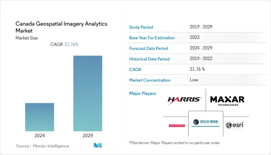
The Canadian geospatial imagery analytics market has been valued at USD 0.70 billion in the current year. It is expected to register a CAGR of 21.76% during the forecast period to reach USD 1.87 billion by the next five years.
Key Highlights
- The size of Canada's geospatial imagery market has seen substantial expansion over recent years, driven by technological advancements, expanding application areas, and increasing demand for geospatial information. Government initiatives in Canada have been crucial in boosting market growth, supporting open data policies, and developing geospatial infrastructure.
- The growing use of satellite imagery in agriculture for crop monitoring and precision farming has driven the market forward. Additionally, the mining sector uses satellite imagery for exploration and monitoring activities. Urban planning and environmental monitoring have also been significant market growth drivers.
- Technological advancements in satellite technology, such as improved spectral capabilities and reduced data acquisition costs, have made satellite imagery services more accessible to various industries and government agencies. Moreover, the rising focus on climate change and environmental sustainability has further propelled the demand for satellite imagery in monitoring ecosystems and natural disasters.
- Geospatial imagery analytics services are costly, and data acquisition and processing can be a restraint for some users due to its high cost, which could restrict the market adoption in the country. Additionally, satellite imagery may not detect small-scale environmental changes due to its lesser resolution than other imagery techniques.
- The COVID-19 pandemic had a mixed impact on the geospatial imagery analytics market. While it brought challenges, such as an economic slowdown, delayed projects, and disrupted supply chains, it also presented growth opportunities. The demand for remote monitoring, disaster response, and precision agriculture increased, highlighting the importance of satellite imagery services in critical applications.
Canada Geospatial Imagery Analytics Market Trends
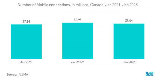
Increasing Adoption of 5G in Canada is Boosting the Market Growth
- The emergence and deployment of fifth-generation (5G) wireless technology have revolutionized the digital landscape, offering unprecedented data speeds, low latency, and enhanced connectivity. As one of the frontrunners in 5G implementation, Canada has witnessed a surge in technological advancements and opportunities. One such sector experiencing significant growth is geospatial analytics. Geospatial analytics leverages location-based data from various sources, such as satellites, sensors, and mobile devices, to gain valuable insights and make informed decisions.
- One critical way geospatial imagery analytics transforms the internet landscape is through optimizing network infrastructure. By analyzing geospatial data, service providers can identify optimal locations for network towers, ensuring maximum coverage and minimizing connectivity issues. This is particularly beneficial in remote and rural areas, where connectivity has traditionally been challenging.
- Moreover, geospatial imagery analytics plays a crucial role in planning and implementing 5G networks. The high-frequency nature of 5G signals requires a dense network of small cells. Geospatial data can help identify the best locations for these cells, considering factors such as building density and terrain. This ensures efficient network deployment and robust connectivity.
- In addition to enhancing network infrastructure, geospatial imagery analytics also improves the user experience. Service providers can optimize network performance based on usage patterns by analyzing user location data. This leads to improved service quality and customer satisfaction.
- Furthermore, geospatial imagery analytics is facilitating the development of smart cities. By integrating geospatial data with Internet technology, city planners can create more efficient and sustainable urban environments. For instance, geospatial data can help optimize traffic management systems, reducing congestion and improving mobility.
AI will Drive the Market
- Canada has always been a frontrunner in implementing and advancing new earth observation satellite system technologies. Among the key areas Canada has significantly contributed to are high-resolution imaging, SAR, hyperspectral imaging, CubeSats, AI/ML, and data analytics. These advancements have facilitated improved monitoring, analysis, and understanding of Earth's systems, benefiting industries, scientific research, and environmental management.
- One of the key advancements is the development of high-resolution imaging systems. Canada has been at the forefront of this technology, with companies like MDA (MacDonald, Dettwiler, and Associates) leading the way. These satellites employ sophisticated optical sensors and advanced image processing techniques to capture detailed images of the Earth's surface. High-resolution imaging enables accurate mapping, urban planning, disaster management, and resource exploration.
- Moreover, the government is continuously increasing investments in its satellites. Hence, in March 2023, the Canadian government invested USD 6.8 million in developing new Earth observation technologies in several areas. The Canadian Space Agency's Space Technology Development Program (STDP) has awarded 10 R&D contracts to 10 companies.
- Integrating artificial intelligence and machine learning algorithms in geospatial imagery analytics is revolutionizing data analysis and interpretation. These technologies enable automated image processing, feature extraction, and pattern recognition, reducing the time and effort required for manual analysis. Canada has strong expertise in AI and ML, and researchers are applying these techniques to satellite data for enhanced land cover classification, vegetation monitoring, and disaster response.
Canada Geospatial Imagery Analytics Industry Overview
The Canada Geospatial Imagery Analytics Market is inclining towards fragmentation as more players emerge who provide software for management and monitoring. Some major players include Harris Corporation, Maxar Technologies, ESRI Inc., BAE Systems, and Satellite Imaging Corporation.
In February 2023, with its partner Esri Canada, the City of Guelph was chosen as the Canadian city to lead the creation of a new emergency services geographic information system (GIS) database. As Canada implements a modernized Next Generation 9-1-1 (NG9-1-1) emergency response system, this innovative partnership, which received USD 1.017 million in federal grant funding, will support crucial enhancements in public safety in Guelph and throughout the country.
In June 2022, industries required X and Y coordinates to place names in order to locate, map, and evaluate various other forms of valuable geospatial data. Users in a variety of industries want to transform incomplete addresses or place names into intelligence that can be used in real-world situations. Esri, the global leader in location intelligence, has teamed up with real estate data analytics provider LightBox to provide advanced geocoding solutions in Canada to meet this demand. Both ArcGIS Online and ArcGIS Platform users can use the service. The LightBox enhancement will enable more precise geocoding of addresses, subaddresses, and locations with multiple units for rooftop locations.
Additional Benefits:
- The market estimate (ME) sheet in Excel format
- 3 months of analyst support
TABLE OF CONTENTS
1 INTRODUCTION
- 1.1 Study Assumptions and Market Definition
- 1.2 Scope of the Study
2 RESEARCH METHODOLOGY
3 EXECUTIVE SUMMARY
4 MARKET INSIGHTS
- 4.1 Market Overview
- 4.2 Industry Attractiveness - Porter's Five Forces Analysis
- 4.2.1 Bargaining Power of Buyers
- 4.2.2 Bargaining Power of Suppliers
- 4.2.3 Threat of New Entrants
- 4.2.4 Threat of Substitutes
- 4.2.5 Intensity of Competitive Rivalry
- 4.3 Industry Value Chain Analysis
- 4.4 Assessment of the Impact of COVID-19 on the Market
5 MARKET DYNAMICS
- 5.1 Market Drivers
- 5.1.1 Increasing Demand for Location-based Services
- 5.1.2 Technological Innovations in Geospatial Imagery Services
- 5.2 Market Restraints
- 5.2.1 Lack of Awareness About Benefits of Geospatial Imagery Services
6 MARKET SEGMENTATION
- 6.1 By Type
- 6.1.1 Imagery Analytics
- 6.1.2 Video Analytics
- 6.2 By Deployment Mode
- 6.2.1 On-premise
- 6.2.2 Cloud
- 6.3 By Organization Size
- 6.3.1 SMEs
- 6.3.2 Large Enterprises
- 6.4 By Verticals
- 6.4.1 Insurance
- 6.4.2 Agriculture
- 6.4.3 Defense and Security
- 6.4.4 Environmental Monitoring
- 6.4.5 Engineering and Construction
- 6.4.6 Government
- 6.4.7 Other Verticals
7 COMPETITIVE LANDSCAPE
- 7.1 Company Profiles
- 7.1.1 Harris Corporation
- 7.1.2 Trimble Inc.
- 7.1.3 Google LLC
- 7.1.4 Maxar Technologies
- 7.1.5 ESRI Inc.
- 7.1.6 BAE Systems
- 7.1.7 Eos Data Analytics
- 7.1.8 Satellite Imaging Corporation
8 INVESTMENT ANALYSIS
9 MARKET OPPORTUNITIES AND FUTURE TRENDS

