
PUBLISHER: Mordor Intelligence | PRODUCT CODE: 1637781

PUBLISHER: Mordor Intelligence | PRODUCT CODE: 1637781
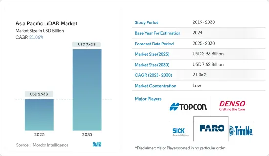
Asia Pacific LiDAR - Market Share Analysis, Industry Trends & Statistics, Growth Forecasts (2025 - 2030)
The Asia Pacific LiDAR Market size is estimated at USD 2.93 billion in 2025, and is expected to reach USD 7.62 billion by 2030, at a CAGR of 21.06% during the forecast period (2025-2030).
LiDAR-based mapping solutions are agile and can be used on a stationary or moving vehicle. Owing to this, they are being adopted by a growing number of industries, especially for application in engineering, construction, environment, and exploration, proving the effectiveness and, therefore, demand for this technology.
Key Highlights
- These LiDARs are also used for the planning of field campaigns and mapping under the forest canopy. Spain-based scientists improved the annual and seasonal mapping accuracy with LiDAR data (from 73% to 83%). Moreover, another major driving factor for the LiDAR market is the increasing use of drones for multiple applications, such as aerospace and defense and automation, which are leading organizations to invest in drone research.
- In this region, LiDAR system applications are also being deployed in defense, geological surveys, pollution monitoring, transport, energy, and construction sectors, coupled with drones. Additionally, countries such as India and China are expected to increase, speeding an average of USD 7 billion in drone technology for defense in the forecast period.
- In Malaysia, the government has been using LiDAR to map the water table depth, flood risk in coastal areas, and canal-blocking restoration requirements. The increase in such adoption of LiDAR systems by governments across different countries in the region is expected to positively contribute to the market's growth over the forecast period.
- Japan's Mitsubishi Electric Corporation unveiled a new compact LiDAR solution for autonomous vehicles, equipped with MEMS that can enhance the horizontal vision span and pedestrian detection capabilities of the self-driving vehicle, with a volume of around 900cc. The company is also planning to develop a smaller LiDAR variant with a volume of just 350cc or less.
- Furthermore, the COVID-19 pandemic led to lockdowns all over the world. This disrupted the exports of automotive parts as well as the manufacturing process. Moreover, the expensive nature of the systems is challenging the adoption of these systems. Companies such as Ford and Baidu were investing in these systems to develop low-cost LiDAR systems.
APAC LiDAR Market Trends
Ground-based LiDAR Expected to Witness The Highest Growth
- The ground-based LiDAR systems have been widely used in close-range and high accuracy applications, especially in architectural restoration, facilities inventory, erosion mapping, stability detection, and various applications in the manufacturing industry. Static and dynamic variations are frequently incorporated in the exploration, engineering, and other mobile mapping systems, along with the GPS referencing techniques for precision and accuracy.
- The ground-based fixed LiDARs are relatively less costly, as these devices can avoid the use of IMU in air-borne systems or LiDAR scanners mounted on vehicles. Such features make the use of ground-based LiDAR cost-effective for the industries and can do the mapping in case of emergency and disaster management, in case of occurrence of any unwanted events.
- low costs associated with ground-based LiDAR systems, coupled with lesser stringent regulations for mapping or survey, are expected to drive the growth of this segment.
- High-resolution snow/soil depth and snow/soil depth change maps can be used from terrestrial laser scanning (TLS) data to quantify loading patterns of avalanche/landslides, in snow/landslide-prone regions, for use in both pre-control plannings and in post-control assessment in case of such events, which increases the application base of such products suitable to a diverse base of end-users.
- The automotive sector is emerging as an application area for mobile ground-based LiDAR systems within this region. According to the Ministry of Road Transport and Highways of India, the installation of the ADAS system is mandatory in all new vehicles (heavy-duty included) by 2022. Hence these types of government initiatives will definitely support the growth of this market.
Growing Aerospace and Defense Industry Expected to Drive Market Growth
- LiDAR has made limited leeway in the aerospace and defense industry. Still, there is potential for research to determine the extent of usage of LiDAR technology in the defense industry. The use of drones to monitor unexplored territory is crucial in the defense industry, and the use of LiDAR technology to analyze data through obstacles plays a vital role in identifying anomalies.
- Higher resolution systems are deployed to collect details to identify targets and movement through the forest canopies and other obstacles, such as Airborne Laser Mine Detection System (ALMDS) for the counter-mine warfare. Short-range LiDARs are utilized for identifying the presence of gases and liquids and other bio-threats in hazardous locations.
- The ability to detect rapidly and respond in real-time gives the LiDAR technology a significant edge over the other conventional technologies which have been implemented in the industry
- Moreover, different government initiatives are also influencing the growth of this market. For instance, The Indian government is also planning to carry LiDAR surveys for all the roads in the northeastern states. It will also help to promote the local providers for this market.
- Owing to the extensive use of the LiDAR system in defense, geological surveys, and energy and construction sectors, different countries such as India and China, are expected to increase speeding an average of USD 7 billion in drone technology for defense in the forecast period.
APAC LiDAR Industry Overview
The Asia Pacific Lidar market is highly competitive due to the presence of many players within this region. Most major vendors invest heavily in their research and development sections to create a unique differentiation from their other competitors. Some major vendors for this market are Topcon Corporation, Denso Corporation, Leishen Intelligent Systems, etc.
- September 2022 - Hexagon subsidiary Leica Geosystems revealed the Leica DMC-4, an effective airborne imaging sensor that offers unmatched image quality for use in challenging mapping scenarios. Customers would gain from this collaboration by receiving a flexible and effective large-format solution for a range of application uses.
- January 2022 - A provider of monitoring devices, EcoTech Ltd., and YellowScan have partnered. The business would expand its study and applications in ecological monitoring, forestry, agriculture, mapping, and surveying through this partnership. The business would also cater to the China market.
Additional Benefits:
- The market estimate (ME) sheet in Excel format
- 3 months of analyst support
TABLE OF CONTENTS
1 INTRODUCTION
- 1.1 Study Assumptions and Market Definition
- 1.2 Scope of the Study
2 RESEARCH METHODOLOGY
3 EXECUTIVE SUMMARY
4 MARKET INSIGHTS
- 4.1 Industry Attractiveness - Porter's Five Forces Analysis
- 4.1.1 Threat of New Entrants
- 4.1.2 Bargaining Power of Buyers
- 4.1.3 Bargaining Power of Suppliers
- 4.1.4 Threat of Substitute Products
- 4.1.5 Intensity of Competitive Rivalry
- 4.2 Industry Value Chain Analysis
- 4.3 Impact of COVID-19 on the Market
5 MARKET DYNAMICS
- 5.1 Market Drivers
- 5.1.1 Growing Applications in the Government Sector
- 5.1.2 Increasing Adoption in the Automotive Industry
- 5.2 Market Restraints
- 5.2.1 High Cost of the LiDAR Systems
6 MARKET SEGMENTATION
- 6.1 Product
- 6.1.1 Aerial LiDAR
- 6.1.2 Ground-based LiDAR
- 6.2 Components
- 6.2.1 GPS
- 6.2.2 Laser Scanners
- 6.2.3 Inertial Measurement Unit
- 6.2.4 Other Components
- 6.3 End User
- 6.3.1 Engineering
- 6.3.2 Automotive
- 6.3.3 Industrial
- 6.3.4 Aerospace and Defense
7 COMPETITIVE LANDSCAPE
- 7.1 Company Profiles
- 7.1.1 Leica Geosystems AG
- 7.1.2 Topcon Corporation
- 7.1.3 Neptec Technologies Corp.
- 7.1.4 Sick AG
- 7.1.5 Trimble Inc.
- 7.1.6 Denso Corporation
- 7.1.7 Faro Technologies Inc.
- 7.1.8 Hesai Technology
- 7.1.9 Benewake
- 7.1.10 RoboSense LiDAR
- 7.1.11 Leishen Intelligent Systems
8 INVESTMENT ANALYSIS
9 FUTURE OF THE MARKET

