
PUBLISHER: Mordor Intelligence | PRODUCT CODE: 1408449

PUBLISHER: Mordor Intelligence | PRODUCT CODE: 1408449
Argentina Satellite Imagery Services - Market Share Analysis, Industry Trends & Statistics, Growth Forecasts 2024 - 2029
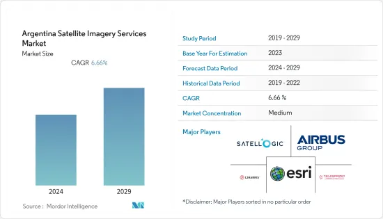
The Argentina satellite imagery services market is valued at USD 0.04 billion in the current year. It is expected to register a CAGR of 6.66% during the forecast period to become USD 0.05 billion by the next five years.
Key Highlights
- Growing concerns about climate change, environmental degradation, and disaster monitoring are driving up demand for satellite imagery services in the country. Furthermore, governments raise their defense budgets as security concerns and geopolitical conflicts between countries develop. They're using commercial satellite photography to give data that will assist them in improving defense and security operations. Satellite imaging also offers information on the planet's chemical, physical, and biological aspects.
- Several applications of satellite-based imaging include navigation, mapping and GIS, emergency and safety, geo-marketing and advertising, enterprise applications, sports, augmented reality/games, mHealth, personal tracking, and social networking. All these applications are being tailor-made to satisfy different needs and usage conditions. The rise of context-aware and augmented reality apps, coupled with the increasing shipments of devices with location-based services, is expected to further augment the market during the forecast period. The fastest-growing positioning methods are based on mobile positioning and satellite-based GPS.
- In July 2023, the Minister of Science, Technology and Innovation of the Nation signed, on behalf of the Argentine company VENG, an agreement with the Indian company Suhora, which specializes in providing solutions with geospatial analysis, to commercialize SAOCOM scenes in new markets. In this way, Suhoraw will be able to offer its clients both in India and in new markets in Asia, as well as throughout the African continent, the scenes from the SAOCOM 1 A and 1B satellites. This radar technology allows information to be detected in any weather and time condition (day and night). Specifically, the L Band, unlike other types of bands, manages to penetrate the vegetation and the soil surface, being able to generate moisture maps of vital importance for agriculture.
- Satellite imagery and GIS systems allow security and law enforcement agencies to identify hot spots, along with other trends and patterns for crime mapping. Accurate detection of spatial concentrations of crime and timely mapping of crime locations help law enforcement identify the concentration of crimes in space and time, thus providing important information for crime reduction efforts. Such imagery helps provide efficiency and speed of analysis in this area of application by allowing analysts to overlay other datasets, such as census demographics and locations of stores, banks, and schools. This helps administrators in the security departments to understand the underlying causes of crime and devise strategies. These strategies include allocating police officers and dispatching them to emergencies.
- Conversely, aerial and terrestrial imaging solutions pose a significant challenge to the market's growth, as they provide better resolution than satellite imaging. In addition, the inability of satellites to work in adverse weather conditions, such as fog, snow, and cloud cover, also restricts the market growth. Aerial imaging can be carried out under cloud cover, with minor corrections applied during post-processing. This guarantees cloud-free data delivery. Due to low altitude acquisition, aerial data does not suffer from atmospheric effects, which can impact the quality of the data in satellite imagery.
- During the COVID-19 pandemic, the satellite industry played a significant role. Satellites provide a variety of voice, data, and broadcast communications options, as well as navigation, earth observation, remote sensing, and other unique services critical to businesses, government clients, and consumers both at home and abroad. Companies are also launching programs to enable the public and employees to cope with the pandemic. As a result, international space agencies are using satellites to depict the effects of COVID-19 on the entire Earth.
Argentina Satellite Imagery Services Market Trends
Natural Resource Management is Expected to Significant Share
- Satellite imaging is helping farmers conduct crop forecasting and manage their agriculture production by utilizing multispectral imagery. The data generated by these methods is then used in GIS management systems to analyze and visualize agricultural environments and workflows. However, free tools, like Google Earth Pro, are helping regional farmers identify areas in fields requiring a closer analysis to decide if additional irrigation or fertilization of the crop is required.
- It is highly essential to understand how forests in climate transition regions respond to climate change. Satellite imaging can help contain the global climate change that has a large effect on the structure and function of vegetation. As officials in the industry are moving from undertaking only corrective measures toward prevention, the market studied may witness huge growth rates. For coastal management researchers and scientists, satellite imaging provides data for the assessment and analysis of water temperature, salinity, phytoplankton, hydrology, shoreline changes, bathymetry, soil moisture, and potential threats to coasts.
- With the advancement of technology, players in the satellite technology space are focusing on new innovations. For instance, Satellogic, a company based out of Argentina, has a target of obtaining a 1-meter resolution image of the planet every week, which can provide precise measurements, particularly in water usage. The agricultural sector can benefit by gathering updated information, ranging from individual fields to entire farm operations and beyond.
- However, for large areas with pan-sharped vegetation indices, resolutions of 30 cm, 40 cm, or 50 cm are required. Thus, the satellite is expected to use these high- and medium-resolution satellite images, particularly for precision agriculture, with minimum commitments of 50-100 km² per area. Major applications within this segment are assessing deforestation and managing coastal lines, driven by commercial logging, forest farming, fuelwood gathering, agriculture, and pasture clearance. Furthermore, changing conditions due to urban sprawl, as well as increasing forest fragmentation, led to an increasing focus on forest productivity, reforestation, forest health, conservation of soil, water resources, and nutrient cycling.
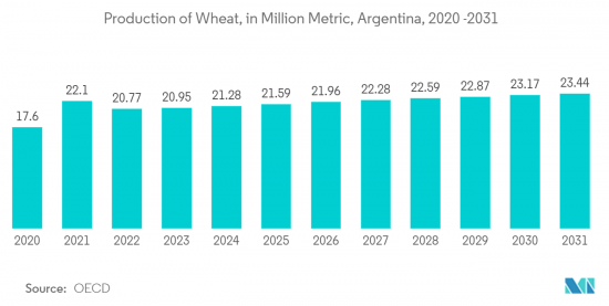
- According to the Organization for Economic Co-operation and Development (OECD), The production volume of wheat in Argentina was forecast to continuously increase by 2.7 million metric tons (+13%) within the next years. Therefore, the production volume is estimated to amount to 23.44 million metric tons in 2031. Production is the process of manufacturing goods. The output is generally measured in volume. Image data is collected and translated into management systems for crop health and better production targets using high-resolution, multispectral satellite or aerial photography and artificial Intelligence (AI), machine learning (ML), and computer vision (CV) algorithms.
Construction Segment is Expected to Drive the Market
- Construction progress can be monitored with regular satellite imagery snapshots of the site from above. Managing this process through organizing drone or aerial imagery can be both expensive and logistically challenging, particularly across various projects. Therefore, using satellite imagery across such projects can be a cost-effective solution. Additionally, monitoring many construction sites' progress can be costly and time-consuming. However, having an updated record of images from above can provide project managers with an easy and quick insight into the progress of their project, which they can use for internal reporting.
- The key stakeholders engaged in large-scale construction projects, such as developers or project managers, are often based in separate locations in the country. Having access to up-to-date satellite imagery of these projects helps these stakeholders monitor their projects easily online. Satellite imagery can benefit various stages of the construction process, equipping key stakeholders with valuable data to achieve informed planning and decision-making. Real estate developers use this imagery when searching or evaluating the site; engineers and architects use it to give their designs an up-to-date geographical context; and project managers consult images over time to monitor the build process.
- The average large construction firm has multiple projects running simultaneously in the country. Satellite images provide an economical, accurate, and rapid means of obtaining a quick assessment for any significant construction or engineering project, e.g., airstrip, power plant, sewer, bridge, dam, industrial park, canal, and storm utilities. For large construction companies undertaking projects in the country, satellite imaging is becoming incredibly important. Extensive surveys and explorations of potential building sites must be undertaken before any work begins. Companies need detailed images of their sites and surrounding areas regularly to better understand the context.
- According to the National Institute of Statistics and Censuses (Argentina), the number of building permits in Argentina increased from 2021 to 2022. In 2022, it was accounted for 57.24 thousand. The images generated from aerial imaging are used to market the construction projects. These images can be utilized to create 3D BIM models and shared with stakeholders to showcase the viability of the projects. The benefits of aerial imaging technology are resulting in the efficient management of energy and resources, which is restraining the market growth.
- As the market continues to evolve, significant firms in the country are increasingly relying on technologies such as AI and Machine learning to scan daily satellite imagery, detect and classify items, and track even minor changes. Artificial intelligence (AI) primarily helps extract valuable insights from the rapidly growing satellite imagery, thus presenting solid AI-driven data analytics for various applications. Technologies like machine learning offer better clarity and visualization by interpreting the images from different vantage points. Artificial intelligence (AI) primarily enables extracting valuable insights from the rapidly growing commercial satellite imagery.
Argentina Satellite Imagery Services Industry Overview
The Argentina Satellite Imagery Services market exhibits moderate consolidation, featuring several key players such as ESRI, Satellogic, Airbus Group Inc, L3 Harris Corporation, and Telespazio, among others. These companies are actively engaged in strategic partnerships and ongoing product development initiatives to expand their market presence. Notable recent developments in the market include:
In September 2023, EOS Data Analytics, a global AI-powered satellite imagery analytics firm, entered into a strategic partnership with Agro Gestion, a company specializing in primary production and agribusiness management. This collaboration is aimed at introducing cutting-edge technological solutions in Argentina, with plans to extend the initiative to Paraguay and Spain. The primary goal is to leverage advanced technology to transform the agricultural landscape. As part of its strategy to grow in the Latin American market and emphasize innovation and efficiency, Agro Gestion is broadening its technological portfolio with the introduction of EOSDA Crop Monitoring, an online platform for precision agriculture based on satellite imagery for field monitoring.
In April 2023, the National Commission for Space Activities of Argentina (CONAE), the nation's leading space agency, joined forces with ReOrbit, a prominent developer of software-defined satellites, to collaborate on the development of the next generation of Earth observation satellites. VENG, a high-value-added space technology and services firm, is also involved in this significant project. ReOrbit plans to utilize its adaptable software-defined satellite platform called Gluon for this venture. Gluon is capable of supporting a wide range of payloads, including optical inter-satellite communications and remote sensing capabilities. This partnership represents a substantial step forward in enhancing Argentina's capabilities in space technology and Earth observation.
Additional Benefits:
- The market estimate (ME) sheet in Excel format
- 3 months of analyst support
TABLE OF CONTENTS
1 INTRODUCTION
- 1.1 Study Assumptions and Market Definition
- 1.2 Scope of the Study
2 RESEARCH METHODOLOGY
3 EXECUTIVE SUMMARY
4 MARKET INSIGHTS
- 4.1 Market Overview
- 4.2 Industry Attractiveness - Porter's Five Forces Analysis
- 4.2.1 Bargaining Power of Buyers
- 4.2.2 Bargaining Power of Suppliers
- 4.2.3 Threat of New Entrants
- 4.2.4 Threat of Substitutes
- 4.2.5 Intensity of Competitive Rivalry
- 4.3 Industry Value Chain Analysis
- 4.4 Assessment of the Impact of COVID-19 on the Market
5 MARKET DYNAMICS
- 5.1 Market Drivers
- 5.1.1 Increasing Adoption of Location-based Services
- 5.1.2 Satellite data usage is increasing
- 5.2 Market Restraints
- 5.2.1 Strict government regulations
- 5.2.2 High-resolution Images Offered by Other Imaging Technologies
6 MARKET SEGMENTATION
- 6.1 By Application
- 6.1.1 Geospatial Data Acquisition and Mapping
- 6.1.2 Natural Resource Management
- 6.1.3 Surveillance and Security
- 6.1.4 Conservation and Research
- 6.1.5 Disaster Management
- 6.1.6 Intelligence
- 6.2 By End-User
- 6.2.1 Government
- 6.2.2 Construction
- 6.2.3 Transportation and Logistics
- 6.2.4 Military and Defense
- 6.2.5 Forestry and Agriculture
- 6.2.6 Others
7 COMPETITIVE LANDSCAPE
- 7.1 Company Profiles
- 7.1.1 ESRI
- 7.1.2 Satellogic
- 7.1.3 Airbus Group Inc
- 7.1.4 L3 Harris corporation
- 7.1.5 Telespazio
- 7.1.6 Gallileo Group
- 7.1.7 Dymaxion Labs
- 7.1.8 Google LLC
8 INVESTMENT ANALYSIS
9 MARKET OPPORTUNITIES AND FUTURE TRENDS

