PUBLISHER: Mordor Intelligence | PRODUCT CODE: 2119617

PUBLISHER: Mordor Intelligence | PRODUCT CODE: 2119617
ASEAN Geospatial Analytics - Market Share Analysis, Industry Trends & Statistics, Growth Forecasts (2026 - 2031)
According to Mordor Intelligence, the ASEAN geospatial analytics market size is expected to grow from USD 0.76 billion in 2025 to USD 0.84 billion in 2026 and is forecast to reach USD 1.42 billion by 2031 at 10.97% CAGR over 2026-2031.
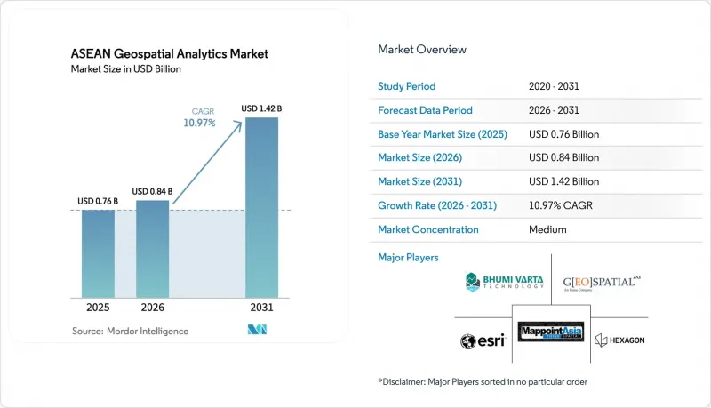
This report is Segmented by Component (Software, Services, and Hardware), Type (Surface Analysis, Network Analysis, and More), End-User Vertical (Government and Public Safety, Defense and Intelligence, and More), Deployment Mode (On-Premise, Cloud, and Edge/Hybrid), Technology (GIS, GPS, Remote Sensing, and More), and Geography. The Market Forecasts are Provided in Terms of Value (USD).
ASEAN Geospatial Analytics Market Trends and Insights
Smart-city Investment Surge Across ASEAN Capitals
Municipal governments are placing geospatial dashboards at the core of city-operations centers. Jakarta's unified spatial portal reduced emergency-response times by 18% in 2025. Thailand's Eastern Economic Corridor earmarked THB 1.5 trillion (USD 42.9 billion) through 2027 for projects that must run pre-build impact assessments using LiDAR-derived digital twins. Hanoi approved USD 1.2 billion for a 3D digital-twin initiative that guides zoning revisions. The ASEAN Smart Cities Network issued 2025 interoperability guidance that references OGC WMS and GeoJSON, lowering vendor integration costs. Indonesia's USD 33 billion Nusantara capital builds drone-based photogrammetry into every construction phase.
Rapid 5G Roll-out Unlocking High-volume, Low-latency Location Data
Completed nationwide 5G coverage in Singapore delivers sub-10 millisecond latency, letting construction firms stream LiDAR point clouds in real time. Malaysia reached 80% population coverage by December 2024, enabling geofenced fleet optimization in Kuala Lumpur. Thailand auctioned 26 GHz spectrum in 2024 and now supports precision-agriculture pilots that cut pesticide use by 12%. Vietnam subsidized 5G base stations in industrial parks where drones audit inventory without Wi-Fi dependencies. The Philippines mandates 5G in disaster-prone municipalities by 2026, supporting rapid drone imagery uploads after typhoons.
High-performance GPU or CPU Costs for Real-time Analytics
A single regional land-cover run on Google Earth Engine can cost USD 200, consuming nearly half of an average Cambodian municipal IT budget. An NVIDIA A100 unit retails at USD 10,000, pushing a basic 16-GPU cluster beyond USD 200,000. Government utilization studies show only 42% GPU use, meaning agencies overpay for idle capacity. While cloud GPU rentals like V100 instances lower capex, recurring bills still strain multi-year budgets.
Other drivers and restraints analyzed in the detailed report include:
- National Geospatial Data-sharing Mandates
- AI-ready Satellite Constellations Slashing Image Refresh Cycles
- Fragmented Spatial Data Standards Among ASEAN Member States
For complete list of drivers and restraints, kindly check the Table Of Contents.
Segment Analysis
Services expanded at a 12.41% CAGR, eclipsing the dominance software maintained with a 52.46% ASEAN Geospatial Analytics market share in 2025. Agencies lacking in-house talent are outsourcing LiDAR flights, satellite-image preprocessing, and custom model-building. Esri Thailand recorded a 23% jump in professional-services bookings during 2025. Hardware remains essential for data capture, with Trimble's Catalyst DA2 bringing decimeter accuracy to smartphones.
Cloud-native spatial engines such as PostGIS and Oracle Spatial permit elastic scaling during seasonal peaks. Hexagon's BLK2FLY drone pairs real-time object classification with automated cloud uploads, trimming post-processing by 40%. Vendors increasingly bundle hardware leasing, cloud compute, and professional services under outcome-linked contracts, blurring component boundaries inside the ASEAN Geospatial Analytics market.
Spatial AI and predictive modeling are growing at a 13.17% CAGR, rapidly narrowing the gap with surface analysis, which held 38.26% of ASEAN Geospatial Analytics market size in 2025. The Philippine Space Agency achieved 92% accuracy detecting informal settlements via a CNN trained on Planet imagery. HERE Technologies reported 11% delivery-time reductions after embedding real-time traffic into Jakarta logistics routes.
Surface analysis still dominates flood modeling and slope stability, but integration of long-range weather data is turning static terrain models into seasonal simulations. Network analysis now guides electric-utility substation placement in Malaysia. Geo-visualization has leaped into augmented reality, letting Singapore planners superimpose building envelopes on active construction sites. Across ASEAN Geospatial Analytics market deployments, prescriptive AI is advising wildlife-patrol routes based on predictive poaching heatmaps.
Complete Report Scope:
- By Component
- Software
- Services
- Hardware
- By Type
- Surface Analysis
- Network Analysis
- Geo-visualization
- Spatial AI and Predictive Modelling
- By End-user Vertical
- Government and Public Safety
- Defense and Intelligence
- Utilities and Telecom
- Agriculture
- Mining and Natural Resources
- Real Estate and Construction
- Healthcare
- Automotive and Transportation
- Other End-user Verticals
- By Deployment Mode
- On-premise
- Cloud
- Edge / Hybrid
- By Technology
- GIS
- GPS
- Remote Sensing
- LiDAR
- Web Map Services and APIs
- By Country
- Brunei
- Cambodia
- Indonesia
- Laos
- Malaysia
- Myanmar
- Philippines
- Singapore
- Thailand
- Vietnam
List of Companies Covered in this Report:
- Hexagon AB
- Esri (Thailand) Co., Ltd.
- MappointAsia (Thailand) PCL
- PT Bhumi Varta Technology
- Geospatial AI Sdn Bhd (Uzma Berhad)
- GIS Co., Ltd.
- Intermap Technologies
- Mandalay Technology Co., Ltd.
- Spatialworks Sdn Bhd
- SkyMap Global
- Trimble Inc.
- HERE Technologies
- Maxar Technologies
- Planet Labs PBC
- SuperMap Software Co.
- Google Cloud Geo-Spatial
- Mapbox Inc.
- Alteryx Inc.
- Oracle Spatial
- Fugro N.V.
- Satelligence B.V.
Additional Benefits:
- The market estimate (ME) sheet in Excel format
- 3 months of analyst support
TABLE OF CONTENTS
1 INTRODUCTION
- 1.1 Study Assumptions and Market Definition
- 1.2 Scope of the Study
2 RESEARCH METHODOLOGY
3 EXECUTIVE SUMMARY
4 MARKET LANDSCAPE
- 4.1 Market Overview
- 4.2 Market Drivers
- 4.2.1 Smart-city Investment Surge Across ASEAN Capitals
- 4.2.2 Rapid 5G Roll-out Unlocking High-volume, Low-latency Location Data
- 4.2.3 National Geospatial Data-sharing Mandates (e.g., Thailand GISTDA)
- 4.2.4 ESG-linked Infrastructure Funding Favouring Geospatial Monitoring
- 4.2.5 AI-ready Satellite Constellations Slashing Image Refresh Cycles
- 4.2.6 Indigenous GovTech Platforms Catalysing Local Analytics Ecosystems
- 4.3 Market Restraints
- 4.3.1 High-performance GPU/CPU Costs for Real-time Analytics
- 4.3.2 Fragmented Spatial Data Standards Among ASEAN Member States
- 4.3.3 Shortage of Domain-specific Geospatial Data Scientists
- 4.3.4 Heightened Data-sovereignty Rules Limiting Cross-border Datasets
- 4.4 Impact of Macroeconomic Factors on the Market
- 4.5 Industry Value Chain Analysis
- 4.6 Regulatory Landscape
- 4.7 Porter's Five Forces Analysis
- 4.7.1 Bargaining Power of Buyers
- 4.7.2 Bargaining Power of Suppliers
- 4.7.3 Threat of New Entrants
- 4.7.4 Threat of Substitutes
- 4.7.5 Intensity of Competitive Rivalry
5 MARKET SIZE AND GROWTH FORECASTS (VALUE)
- 5.1 By Component
- 5.1.1 Software
- 5.1.2 Services
- 5.1.3 Hardware
- 5.2 By Type
- 5.2.1 Surface Analysis
- 5.2.2 Network Analysis
- 5.2.3 Geo-visualization
- 5.2.4 Spatial AI and Predictive Modelling
- 5.3 By End-user Vertical
- 5.3.1 Government and Public Safety
- 5.3.2 Defense and Intelligence
- 5.3.3 Utilities and Telecom
- 5.3.4 Agriculture
- 5.3.5 Mining and Natural Resources
- 5.3.6 Real Estate and Construction
- 5.3.7 Healthcare
- 5.3.8 Automotive and Transportation
- 5.3.9 Other End-user Verticals
- 5.4 By Deployment Mode
- 5.4.1 On-premise
- 5.4.2 Cloud
- 5.4.3 Edge / Hybrid
- 5.5 By Technology
- 5.5.1 GIS
- 5.5.2 GPS
- 5.5.3 Remote Sensing
- 5.5.4 LiDAR
- 5.5.5 Web Map Services and APIs
- 5.6 By Country
- 5.6.1 Brunei
- 5.6.2 Cambodia
- 5.6.3 Indonesia
- 5.6.4 Laos
- 5.6.5 Malaysia
- 5.6.6 Myanmar
- 5.6.7 Philippines
- 5.6.8 Singapore
- 5.6.9 Thailand
- 5.6.10 Vietnam
6 COMPETITIVE LANDSCAPE
- 6.1 Market Concentration
- 6.2 Strategic Moves
- 6.3 Market Share Analysis
- 6.4 Company Profiles (includes Global Level Overview, Market Level Overview, Core Segments, Financials as Available, Strategic Information, Market Rank/Share for Key Companies, Products and Services, and Recent Developments)
- 6.4.1 Hexagon AB
- 6.4.2 Esri (Thailand) Co., Ltd.
- 6.4.3 MappointAsia (Thailand) PCL
- 6.4.4 PT Bhumi Varta Technology
- 6.4.5 Geospatial AI Sdn Bhd (Uzma Berhad)
- 6.4.6 GIS Co., Ltd.
- 6.4.7 Intermap Technologies
- 6.4.8 Mandalay Technology Co., Ltd.
- 6.4.9 Spatialworks Sdn Bhd
- 6.4.10 SkyMap Global
- 6.4.11 Trimble Inc.
- 6.4.12 HERE Technologies
- 6.4.13 Maxar Technologies
- 6.4.14 Planet Labs PBC
- 6.4.15 SuperMap Software Co.
- 6.4.16 Google Cloud Geo-Spatial
- 6.4.17 Mapbox Inc.
- 6.4.18 Alteryx Inc.
- 6.4.19 Oracle Spatial
- 6.4.20 Fugro N.V.
- 6.4.21 Satelligence B.V.
7 MARKET OPPORTUNITIES AND FUTURE OUTLOOK
- 7.1 White-space and Unmet-need Assessment

