PUBLISHER: Mordor Intelligence | PRODUCT CODE: 2119645

PUBLISHER: Mordor Intelligence | PRODUCT CODE: 2119645
ANZ Geospatial Analytics - Market Share Analysis, Industry Trends & Statistics, Growth Forecasts (2026 - 2031)
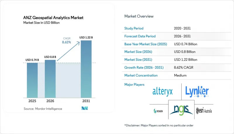
According to Mordor Intelligence, the ANZ geospatial analytics market size is expected to grow from USD 0.74 billion in 2025 to USD 0.8 billion in 2026 and is forecast to reach USD 1.22 billion by 2031 at 8.62% CAGR over 2026-2031.
This report is Segmented by Type (Surface Analysis, Network Analysis, Geovisualization), by End-User Vertical (Agriculture, Utility and Communication, Defense and Intelligence, Government, Mining and Natural Resources, Automotive and Transportation, Healthcare, Real Estate and Construction, Other End-User Verticals), and by Country. The Market Forecasts are Provided in Terms of Value (USD).
ANZ Geospatial Analytics Market Trends and Insights
AI/ML Infusion Accelerates Mainstream GIS Adoption
Artificial intelligence and machine learning now underpin core GIS workflows across the ANZ geospatial analytics market, reducing manual processing times and enabling real-time decision support. BHP's digital twins conserve more than 3 gigaliters of water and 118 GWh of energy, highlighting tangible sustainability outcomes. GeoAI revenue is forecast to quadruple globally between 2024 and 2029, an outlook that encourages platform vendors to embed pre-trained models and no-code AI pipelines. Universities bolster this trend; the University of Sydney's soil-moisture tool merges satellite imagery with sensor feeds at 80 m2 resolution to fine-tune irrigation scheduling. Natural-language GIS copilots are appearing, letting planners pose queries such as "Highlight parcels with flood risk above
Smart-City and Digital-Twin Programs Drive Infrastructure Investment
State-level programs in Victoria and New South Wales allocate more than USD 77 million to create immersive 4D models for transport planning and hazard management. Wellington's Digital Twin layers traffic counts, air-traffic patterns, and IoT sensor data so officials can visualize the effect of proposed bridges before construction. Private developers also gain; Lendlease reports potential 20% cost savings and 100-fold speed-to-market improvements when digital twins guide scheduling decisions.
High Platform and Data Licensing Costs Constrain SME Adoption
Enterprise-grade GIS suites command initial license fees exceeding USD 11,500 plus annual subscriptions above USD 3,800, a hurdle for small contractors and councils . Cloud hosting adds variable storage and bandwidth surcharges that make budgeting unpredictable, often stalling proof-of-concept pilots. Competitive responses include Euclideon's subscription-based 3D data hub that bundles free viewers to lower entry frictio. Yet until price transparency improves, many SMEs postpone full digital-twin rollouts, tempering near-term expansion of the ANZ geospatial analytics market.
Other drivers and restraints analyzed in the detailed report include:
- Post-COVID Infrastructure Stimulus Fuels Geospatial Capital Expenditure
- Mandatory Spatial-Data Reporting Transforms Compliance Workflows
- Shortfall of Geospatial Data-Science Talent Threatens Growth
For complete list of drivers and restraints, kindly check the Table Of Contents.
Segment Analysis
Solutions generated the largest slice of the ANZ geospatial analytics market in 2025 at 62.40%, buoyed by entrenched platform investments that underpin day-to-day mapping, asset tracking, and regulatory reporting. Managed services, however, are climbing at 16.9% CAGR because organizations favor predictable OPEX over perpetual licenses and recognize that outsourcing bridges the talent shortfall. Esri Australia's cloud-hosted managed GIS exemplifies the model, offering SOC2-aligned security plus local help-desk support that frees internal teams from routine patching and scalability chores.
Service vendors now bundle continuous optimization, DevOps pipelines, and training, transforming from project contractors into strategic partners that shepherd digital-twin roadmaps. This dynamic shifts competitive advantage toward firms with multidisciplinary benches data scientists, UX designers, and domain consultants who knit disparate datasets into cohesive decision-support engines. As a result, the ANZ geospatial analytics market sees accelerating migration from solution ownership toward subscription-based ecosystems, a trend reinforced by Trimble's 75% software revenue mix and USD 2.26 billion in annualized recurring revenue.
On-premise installations retained 47.10% revenue in 2025 because mining, defense, and utilities prioritize sovereign control over sensitive geodata. Yet the cloud segment's 21% CAGR underscores growing confidence in hyperscale resilience and cost elasticity. ArcGIS Online's 99.9% uptime pledge, paired with multicloud portability, appeals to agencies seeking cross-jurisdiction collaboration without building redundant data centers.
Hybrid deployments bridge risk and agility, letting organizations containerize workloads that burst to the cloud for AI training or terabyte-scale rendering while retaining crown-jewel layers on site. Government fiber rollouts and SouthPAN accuracy upgrades further erode latency constraints, making it feasible to stream high-resolution elevation models or live drone feeds over public networks. Consequently, the ANZ geospatial analytics market observes an architectural pivot: cloud-native micro-services handle ingest, analytics, and visualization pipelines, whereas legacy on-prem clusters become staging areas or data-sovereignty vaults.
Complete Report Scope:
- By Component
- Solutions
- Services
- By Deployment Model
- On-premise
- Cloud
- Hybrid
- By Analytics Technique
- Descriptive
- Predictive
- Prescriptive
- By Type
- Surface Analysis
- Network Analysis
- Geovisualization
- By End-user Vertical
- Agriculture
- Utility and Communication
- Defense and Intelligence
- Government
- Mining and Natural Resources
- Automotive and Transportation
- Healthcare
- Real-Estate and Construction
- Other Verticals
- By Country
- Australia
- New Zealand
List of Companies Covered in this Report:
- Esri Australia Pty Ltd
- NGIS Australia Pty Ltd
- Hexagon AB
- Alteryx Inc.
- Lynker Analytics Ltd
- Intermap Technologies Corp.
- Mapizy Pty Ltd
- CoreLogic NZ Ltd
- Abley Ltd
- Geospatial Intelligence Pty Ltd
- Digital Agriculture Services Pty Ltd
- SRA Information Technology Pty Ltd
- Fugro NV
- Nearmap Ltd
- Trimble Inc.
- Maxar Technologies Inc.
- Google Australia Pty Ltd (Google Cloud Geo)
- Jacobs Group (Australia) Pty Ltd
- Woolpert Australia Pty Ltd
- FrontierSI Ltd
Additional Benefits:
- The market estimate (ME) sheet in Excel format
- 3 months of analyst support
TABLE OF CONTENTS
1 INTRODUCTION
- 1.1 Study Assumptions and Market Definition
- 1.2 Scope of the Study
2 RESEARCH METHODOLOGY
3 EXECUTIVE SUMMARY
4 MARKET LANDSCAPE
- 4.1 Market Overview
- 4.2 Market Drivers
- 4.2.1 Growing demand from smart-city and digital-twin programs
- 4.2.2 AI/ML infusion into mainstream GIS workflows
- 4.2.3 Post-COVID infrastructure stimulus fuelling geospatial capex
- 4.2.4 Mandatory spatial-data reporting in mining and agriculture
- 4.2.5 Precision-ag ''paddock-level'' decision support requirements
- 4.2.6 Carbon-credit verification using earth-observation datasets
- 4.3 Market Restraints
- 4.3.1 High platform and data licensing costs
- 4.3.2 Fragmented spatial-data standards between AU and NZ
- 4.3.3 Shortfall of geospatial data-science talent
- 4.3.4 Public backlash over location-privacy breaches
- 4.4 Value Chain Analysis
- 4.5 Regulatory Landscape
- 4.6 Technological Outlook
- 4.6.1 Cloud-Native GeoAI Pipelines
- 4.7 Porter's Five Forces
- 4.7.1 Bargaining Power of Buyers
- 4.7.2 Bargaining Power of Suppliers
- 4.7.3 Threat of New Entrants
- 4.7.4 Threat of Substitutes
- 4.7.5 Intensity of Competitive Rivalry
5 MARKET SIZE AND GROWTH FORECASTS (VALUE)
- 5.1 By Component
- 5.1.1 Solutions
- 5.1.2 Services
- 5.2 By Deployment Model
- 5.2.1 On-premise
- 5.2.2 Cloud
- 5.2.3 Hybrid
- 5.3 By Analytics Technique
- 5.3.1 Descriptive
- 5.3.2 Predictive
- 5.3.3 Prescriptive
- 5.4 By Type
- 5.4.1 Surface Analysis
- 5.4.2 Network Analysis
- 5.4.3 Geovisualization
- 5.5 By End-user Vertical
- 5.5.1 Agriculture
- 5.5.2 Utility and Communication
- 5.5.3 Defense and Intelligence
- 5.5.4 Government
- 5.5.5 Mining and Natural Resources
- 5.5.6 Automotive and Transportation
- 5.5.7 Healthcare
- 5.5.8 Real-Estate and Construction
- 5.5.9 Other Verticals
- 5.6 By Country
- 5.6.1 Australia
- 5.6.2 New Zealand
6 COMPETITIVE LANDSCAPE
- 6.1 Market Concentration
- 6.2 Strategic Moves
- 6.3 Market Share Analysis
- 6.4 Company Profiles (includes Global level overview, Market level overview, Core segments, Financials as available, Strategic information, Market Rank/Share, Products & Services, Recent Developments)
- 6.4.1 Esri Australia Pty Ltd
- 6.4.2 NGIS Australia Pty Ltd
- 6.4.3 Hexagon AB
- 6.4.4 Alteryx Inc.
- 6.4.5 Lynker Analytics Ltd
- 6.4.6 Intermap Technologies Corp.
- 6.4.7 Mapizy Pty Ltd
- 6.4.8 CoreLogic NZ Ltd
- 6.4.9 Abley Ltd
- 6.4.10 Geospatial Intelligence Pty Ltd
- 6.4.11 Digital Agriculture Services Pty Ltd
- 6.4.12 SRA Information Technology Pty Ltd
- 6.4.13 Fugro NV
- 6.4.14 Nearmap Ltd
- 6.4.15 Trimble Inc.
- 6.4.16 Maxar Technologies Inc.
- 6.4.17 Google Australia Pty Ltd (Google Cloud Geo)
- 6.4.18 Jacobs Group (Australia) Pty Ltd
- 6.4.19 Woolpert Australia Pty Ltd
- 6.4.20 FrontierSI Ltd
7 Market Opportunities and Future Outlook
- 7.1 White-space and Unmet-need Assessment
8 Investment Analysis

