PUBLISHER: Mordor Intelligence | PRODUCT CODE: 2119640

PUBLISHER: Mordor Intelligence | PRODUCT CODE: 2119640
France Geospatial Analytics - Market Share Analysis, Industry Trends & Statistics, Growth Forecasts (2026 - 2031)
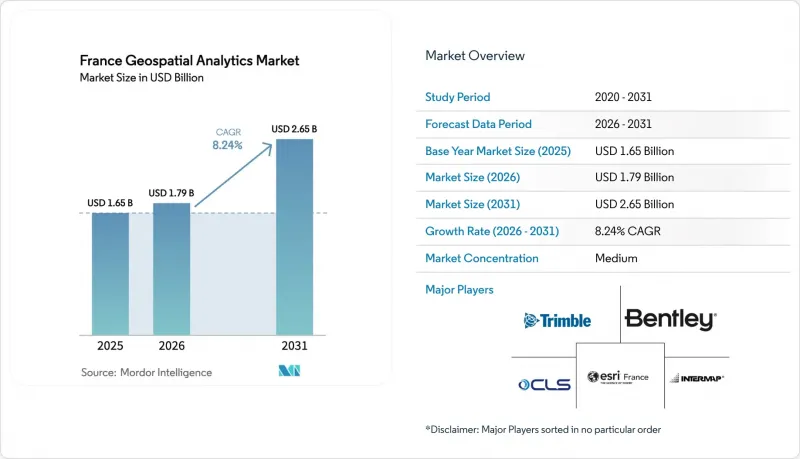
According to Mordor Intelligence, the France geospatial analytics market size is expected to grow from USD 1.65 billion in 2025 to USD 1.79 billion in 2026 and is forecast to reach USD 2.65 billion by 2031 at 8.24% CAGR over 2026-2031.
This report is Segmented by Type (Surface Analysis, Network Analysis, and Geovisualization) by End User Vertical (Agriculture, Utility and Communication, Defense and Intelligence, Government, Mining and Natural Resources, Automotive and Transportation, Healthcare, Real Estate and Construction, and More), and Geography.
France Geospatial Analytics Market Trends and Insights
Smart city and mobility funding surge
France is channeling EUR 475 million into road construction and a further EUR 294 million into road maintenance in 2025. Municipalities receive these funds only if they can document efficiency gains, which elevates demand for geospatial dashboards that track pavement condition, traffic flow, and carbon footprint in near real time. Istres' private 5G network demonstrates how geospatial analytics cuts municipal operating costs by 40% while improving emergency-response routing accuracy. The national digital-twin platform, spearheaded by IGN, Cerema, and Inria, lets cities simulate flood, heat-island, and traffic scenarios, turning spatial data into predictive asset-management tools. France's commitment to interoperability standards ensures repeatable deployments across 35,000 communes, creating durable revenue streams for vendors whose software supports the new schemas. As volumes of LiDAR, CCTV, and sensor data grow, the France geospatial analytics market will pivot from descriptive mapping to anticipatory decision support.
Defense satellite constellation (CSO-3) demand
The EUR 795 million CSO program supplies 35 cm imagery that meets NATO strategic-intelligence criteria while remaining under French command. Data commercialization clauses permit secure distribution to trusted European partners, generating an export channel that did not exist before. Ukraine's 2025 contract with a Safran subsidiary to fuse CSO data into its defense-planning platform underscores the constellation's market potential beyond France. Downstream, insurers, utilities and foresters gain access to a level of spatial precision previously reserved for defense. The constellation integrates with the C40S space-domain-awareness system, allowing AI algorithms to flag anomalies and send real-time alerts to both civil and military users. Each new analytic use case expands transaction volume, cementing satellite data as the backbone of the France geospatial analytics market.
High integration and migration cost
A full-stack geospatial rollout can exceed EUR 500,000 once data-ingest pipelines, sensor gateways and training programs are factored in. Many small and mid-sized firms delayed projects after construction output fell 8.4% in Q3 2024, showing the sensitivity of spatial-IT budgets to macro conditions. Legacy resource-planning software often lacks spatial fields, forcing companies to purchase middleware and hire specialist integrators. This increases total cost of ownership and makes the payback period less attractive when compared to cloud CRM or ERP investments. Until plug-and-play connectors mature, high entry costs will temper growth in the France geospatial analytics market.
Other drivers and restraints analyzed in the detailed report include:
- ESG and Green-Budget compliance mandates
- 5G-IoT real-time data streams
- Geo-data-science talent shortage
For complete list of drivers and restraints, kindly check the Table Of Contents.
Segment Analysis
Geovisualization held 37.35% of France geospatial analytics market share in 2025, reflecting public agencies' need for map-centric dashboards that non-technical staff can interpret quickly. Budget officers use color-coded layers to rank infrastructure risk, while vineyard managers monitor plant stress on a mobile heatmap. The France geospatial analytics market size for geovisualization is projected to grow at 7.12% CAGR as 3D engines and browser-based point-cloud renderers remove workstation limits. Vendors embed accessibility features such as voice navigation and contrast toggles, supported by research from Universite Claude Bernard Lyon 1 that demonstrated mobile geovisualization benefits for users with visual impairments.
Network analysis is the fastest-growing sub-segment at a 13.15% CAGR through 2031. This surge aligns with expanded electric-vehicle-charger deployment, where planners evaluate optimal station spacing and grid impact. Surface analysis continues to have steady demand from precision-agriculture and mining clients who require terrain-aware fertilizer plans or blast-risk contours. The combined momentum across sub-segments signals that the France geospatial analytics market will broaden from static map production toward analytical workflows that integrate routing, proximity and elevation parameters inside a single interface.
Complete Report Scope:
- By Type
- Surface Analysis
- Network Analysis
- Geovisualization
- By End-user Vertical
- Agriculture
- Utility and Communication
- Defense and Intelligence
- Government
- Mining and Natural Resources
- Automotive and Transportation
- Healthcare
- Real Estate and Construction
- Other End-user Verticals
List of Companies Covered in this Report:
- Esri France
- Airbus Defence and Space Intelligence
- Thales Alenia Space
- Hexagon AB (Leica Geosystems)
- Bentley Systems France
- Safran (AI and geospatial)
- IGN (Geoservices)
- CLS Groupe
- Intermap Technologies
- Trimble Geospatial
- ACWA Robotics
- Preligens
- Nestwave SAS
- Preligens
- AlphaGeoMega SAS
- Geomatys
- CartONG
- Galigeo
- JLL France (Geo-BI)
- Gismed
Additional Benefits:
- The market estimate (ME) sheet in Excel format
- 3 months of analyst support
TABLE OF CONTENTS
1 INTRODUCTION
- 1.1 Study Assumptions and Market Definition
- 1.2 Scope of the Study
2 RESEARCH METHODOLOGY
3 EXECUTIVE SUMMARY
4 MARKET LANDSCAPE
- 4.1 Market Overview
- 4.2 Market Drivers
- 4.2.1 Smart-city and mobility funding surge
- 4.2.2 Defense satellite constellation (CSO-3) demand
- 4.2.3 ESG and Green-Budget compliance mandates
- 4.2.4 5G-IoT real-time data streams
- 4.2.5 Mandatory biodiversity impact reporting (2026)
- 4.2.6 Precision-viticulture platform adoption
- 4.3 Market Restraints
- 4.3.1 High integration and migration cost
- 4.3.2 Geo-data-science talent shortage
- 4.3.3 Municipal data-standard fragmentation
- 4.3.4 Cloud-sovereignty hosting limits
- 4.4 Value Chain Analysis
- 4.5 Regulatory Landscape
- 4.6 Technological Outlook
- 4.7 Porter's Five Forces Analysis
- 4.7.1 Bargaining Power of Buyers
- 4.7.2 Bargaining Power of Suppliers
- 4.7.3 Threat of New Entrants
- 4.7.4 Threat of Substitutes
- 4.7.5 Intensity of Competitive Rivalry
- 4.8 Industry Value-Chain Analysis
- 4.9 COVID-19 Impact Assessment
5 MARKET SIZE AND GROWTH FORECASTS (VALUE)
- 5.1 By Type
- 5.1.1 Surface Analysis
- 5.1.2 Network Analysis
- 5.1.3 Geovisualization
- 5.2 By End-user Vertical
- 5.2.1 Agriculture
- 5.2.2 Utility and Communication
- 5.2.3 Defense and Intelligence
- 5.2.4 Government
- 5.2.5 Mining and Natural Resources
- 5.2.6 Automotive and Transportation
- 5.2.7 Healthcare
- 5.2.8 Real Estate and Construction
- 5.2.9 Other End-user Verticals
6 COMPETITIVE LANDSCAPE
- 6.1 Market Concentration
- 6.2 Strategic Moves
- 6.3 Market Share Analysis
- 6.4 Company Profiles (includes Global level Overview, Market level overview, Core Segments, Financials as available, Strategic Information, Market Rank/Share for key companies, Products and Services, and Recent Developments)
- 6.4.1 Esri France
- 6.4.2 Airbus Defence and Space Intelligence
- 6.4.3 Thales Alenia Space
- 6.4.4 Hexagon AB (Leica Geosystems)
- 6.4.5 Bentley Systems France
- 6.4.6 Safran (AI and geospatial)
- 6.4.7 IGN (Geoservices)
- 6.4.8 CLS Groupe
- 6.4.9 Intermap Technologies
- 6.4.10 Trimble Geospatial
- 6.4.11 ACWA Robotics
- 6.4.12 Preligens
- 6.4.13 Nestwave SAS
- 6.4.14 Preligens
- 6.4.15 AlphaGeoMega SAS
- 6.4.16 Geomatys
- 6.4.17 CartONG
- 6.4.18 Galigeo
- 6.4.19 JLL France (Geo-BI)
- 6.4.20 Gismed
7 MARKET OPPORTUNITIES AND FUTURE OUTLOOK
- 7.1 White-space and Unmet-need Assessment

